File:Canal du Midi map-fr.svg
Jump to navigation
Jump to search

Size of this PNG preview of this SVG file: 800 × 444 pixels. Other resolutions: 320 × 178 pixels | 640 × 355 pixels | 1,024 × 569 pixels | 1,280 × 711 pixels | 2,560 × 1,422 pixels | 1,048 × 582 pixels.
Original file (SVG file, nominally 1,048 × 582 pixels, file size: 295 KB)
Captions
Captions
Add a one-line explanation of what this file represents
Summary[edit]
| Description |
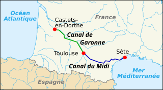
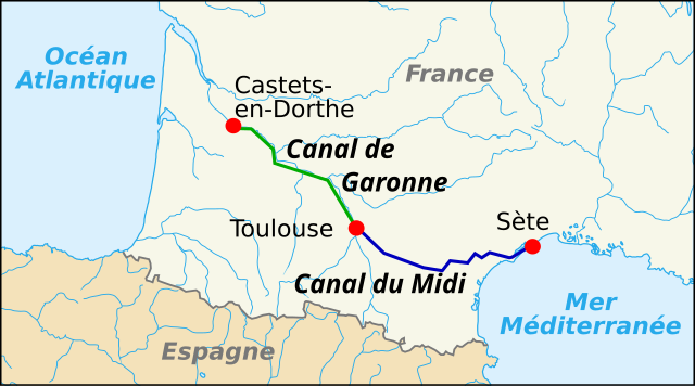
English: SVG map of Canal du Midi in France; french text
Français : Carte en svg du canal du Midi en France ; texte en français |
| Date | |
| Source | Own work based on: France blank.svg and CanalDuMidi map.jpg |
| Author | Pinpin |
| Other versions |
Derivative works of this file:
|
| SVG development |
Licensing[edit]
Pinpin, the copyright holder of this work, hereby publishes it under the following licenses:

|
Permission is granted to copy, distribute and/or modify this document under the terms of the GNU Free Documentation License, Version 1.2 or any later version published by the Free Software Foundation; with no Invariant Sections, no Front-Cover Texts, and no Back-Cover Texts. A copy of the license is included in the section entitled GNU Free Documentation License. |
This file is licensed under the Creative Commons Attribution-Share Alike 3.0 Unported, 2.5 Generic, 2.0 Generic and 1.0 Generic license.
Attribution: Pinpin
- You are free:
- to share – to copy, distribute and transmit the work
- to remix – to adapt the work
- Under the following conditions:
- attribution – You must give appropriate credit, provide a link to the license, and indicate if changes were made. You may do so in any reasonable manner, but not in any way that suggests the licensor endorses you or your use.
- share alike – If you remix, transform, or build upon the material, you must distribute your contributions under the same or compatible license as the original.
You may select the license of your choice.
File history
Click on a date/time to view the file as it appeared at that time.
| Date/Time | Thumbnail | Dimensions | User | Comment | |
|---|---|---|---|---|---|
| current | 19:02, 4 April 2024 | | 1,048 × 582 (295 KB) | Theklan (talk | contribs) | File uploaded using svgtranslate tool (https://svgtranslate.toolforge.org/). Added translation for eu. |
| 11:24, 2 October 2012 |  | 1,048 × 582 (288 KB) | Falcoperegrinus (talk | contribs) | Correction de la localisation de Castets-en-Dorthe, légende plus claire | |
| 19:50, 7 March 2010 |  | 1,047 × 689 (395 KB) | Pinpin (talk | contribs) | ||
| 14:36, 6 October 2007 |  | 1,047 × 689 (395 KB) | Pinpin (talk | contribs) | cadrage | |
| 14:31, 6 October 2007 |  | 1,047 × 840 (395 KB) | Pinpin (talk | contribs) | {{Information |Description={{en|SVG map of Canal du Midi in France; french text}} {{fr|Carte en svg du canal du Midi en France ; texte en français}} |Source=Own work made with Inkscape from Image:France blank.svg and Image:CanalDuMidi map.jpg | |
You cannot overwrite this file.
File usage on Commons
The following 10 pages use this file:
- Canal du Midi
- Canal latéral à la Garonne
- User:Chumwa/OgreBot/Transport Maps/2024 April 1-10
- File:CanalDuMidi map.jpg
- File:Canal du Midi map-de.svg
- File:Canal du Midi map-fr mirrored.svg
- Category:Canal du Midi
- Category:Canal latéral à la Garonne
- Category:Canal locks on the Canal du Midi
- Category:Navigable aqueducts on the Canal du Midi
File usage on other wikis
The following other wikis use this file:
- Usage on ar.wikipedia.org
- Usage on arz.wikipedia.org
- Usage on ca.wikipedia.org
- Usage on de.wikivoyage.org
- Usage on el.wikipedia.org
- Usage on en.wikipedia.org
- Usage on eu.wikipedia.org
- Usage on fi.wikipedia.org
- Usage on fr.wikipedia.org
- Usage on hr.wikipedia.org
- Usage on hu.wikipedia.org
- Usage on it.wikipedia.org
- Usage on lt.wikipedia.org
- Usage on nl.wikipedia.org
- Usage on pt.wikipedia.org
- Usage on ro.wikipedia.org
- Usage on ru.wikipedia.org
- Usage on sh.wikipedia.org
- Usage on sl.wikipedia.org
- Usage on sr.wikipedia.org
- Usage on sv.wikipedia.org
- Usage on th.wikipedia.org
- Usage on uk.wikipedia.org
- Usage on vi.wikipedia.org
- Usage on www.wikidata.org