File:Canadarago lake bathymetric one layer.svg
Jump to navigation
Jump to search

Size of this PNG preview of this SVG file: 474 × 600 pixels. Other resolutions: 190 × 240 pixels | 379 × 480 pixels | 607 × 768 pixels | 809 × 1,024 pixels | 1,619 × 2,048 pixels | 649 × 821 pixels.
Original file (SVG file, nominally 649 × 821 pixels, file size: 111 KB)
Captions
Captions
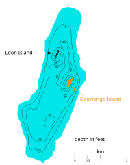
bathymetric map of canadarago lake
Summary[edit]
| Description |
English: bathymetric map of candarago lake, based on Jay A. Bloomfield (Hrsg.): Ecology of the Lakes of East-Central New York. Academic Press (Elsevier), 1980, ISBN 9781483277349, pp. 143-144,166 and Southeastern New York Fishing Map Guide. Sportsman's Connection, 2016, ISBN 9781885010643, pp. 10–11 |
| Date | |
| Source | Own work |
| Author | Kmhkmh |
Licensing[edit]
I, the copyright holder of this work, hereby publish it under the following license:
This file is licensed under the Creative Commons Attribution 4.0 International license.
- You are free:
- to share – to copy, distribute and transmit the work
- to remix – to adapt the work
- Under the following conditions:
- attribution – You must give appropriate credit, provide a link to the license, and indicate if changes were made. You may do so in any reasonable manner, but not in any way that suggests the licensor endorses you or your use.
File history
Click on a date/time to view the file as it appeared at that time.
| Date/Time | Thumbnail | Dimensions | User | Comment | |
|---|---|---|---|---|---|
| current | 09:30, 12 October 2021 | | 649 × 821 (111 KB) | Kmhkmh (talk | contribs) | Uploaded own work with UploadWizard |
You cannot overwrite this file.
File usage on Commons
The following page uses this file: