File:Canada - DPLA - a1377b0f9499e05df9ebb223f9b83144.jpg
Jump to navigation
Jump to search

Size of this preview: 467 × 599 pixels. Other resolutions: 187 × 240 pixels | 374 × 480 pixels | 599 × 768 pixels | 798 × 1,024 pixels | 2,554 × 3,276 pixels.
Original file (2,554 × 3,276 pixels, file size: 5.18 MB, MIME type: image/jpeg)
Captions
Captions
Add a one-line explanation of what this file represents
Summary[edit]
| Canada
( |
||||||||||||||
|---|---|---|---|---|---|---|---|---|---|---|---|---|---|---|
| Author |
Central Intelligence Agency |
|||||||||||||
| Creator | Central Intelligence Agency. 12/4/1981 | |||||||||||||
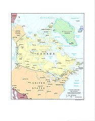
| Title |
Canada |
|||||||||||||
| Description |
Lambert Conformal Conic Projection, standard parallels 52N and 74N. Includes British Columbia, Yukon Territory, Alberta, Northwest Territories (Baffin Island, Ellesmere Island, Queen Elizabeth Islands, Banks Island, and Victoria Island), Saskatchewan, Manitoba, Ontario, Quebec, New Brunswick, Nova Scotia, Prince Edward Island, and Newfoundland. Also includes Saint Pierre and Miquelon (France), United States, Greenland (Denmark), Iceland, Jan Mayen (Norway), Russia, and Mexico. |
|||||||||||||
| Collection |
|
|||||||||||||
| Source/Photographer |
|
|||||||||||||
| Permission (Reusing this file) |
|
|||||||||||||
| Standardized rights statement |
|
|||||||||||||

File history
Click on a date/time to view the file as it appeared at that time.
| Date/Time | Thumbnail | Dimensions | User | Comment | |
|---|---|---|---|---|---|
| current | 22:43, 8 March 2023 | | 2,554 × 3,276 (5.18 MB) | DPLA bot (talk | contribs) | Uploading DPLA ID dpla:a1377b0f9499e05df9ebb223f9b83144 |
You cannot overwrite this file.
File usage on Commons
The following page uses this file: