File:California 29th Congressional District.png
Jump to navigation
Jump to search

Size of this preview: 511 × 600 pixels. Other resolutions: 204 × 240 pixels | 517 × 607 pixels.
Original file (517 × 607 pixels, file size: 129 KB, MIME type: image/png)
Captions
Captions
Add a one-line explanation of what this file represents
Summary[edit]
| Description |
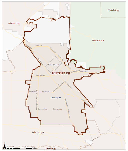
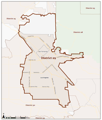
English: Map of the California's 29th congressional district in the U.S. House of Representatives (as of 1 Jan 2013).
Español: Mapa del 29.º distrito congresional de California — norte-oeste del Valle de San Fernando, Condado de Los Ángeles, California. |
| Date | |
| Source | U.S House of Representatives |
| Author | U.S. House of Representatives |
Licensing[edit]
This work is in the public domain in the United States because it is a work prepared by an officer or employee of the United States Government as part of that person’s official duties under the terms of Title 17, Chapter 1, Section 105 of the US Code.
Note: This only applies to original works of the Federal Government and not to the work of any individual U.S. state, territory, commonwealth, county, municipality, or any other subdivision. This template also does not apply to postage stamp designs published by the United States Postal Service since 1978. (See § 313.6(C)(1) of Compendium of U.S. Copyright Office Practices). It also does not apply to certain US coins; see The US Mint Terms of Use.
|
 | |
| This file has been identified as being free of known restrictions under copyright law, including all related and neighboring rights. | ||
en:California's 29th congressional district es:29.º distrito congresional de California
File history
Click on a date/time to view the file as it appeared at that time.
| Date/Time | Thumbnail | Dimensions | User | Comment | |
|---|---|---|---|---|---|
| current | 04:36, 10 March 2013 | | 517 × 607 (129 KB) | Bumblemouse (talk | contribs) | User created page with UploadWizard |
You cannot overwrite this file.
File usage on Commons
There are no pages that use this file.
File usage on other wikis
The following other wikis use this file:
- Usage on pl.wikipedia.org
Categories:
- Congressional district maps of California
- Maps of the San Fernando Valley
- Maps of Los Angeles County, California
- Maps of Los Angeles
- Arleta, Los Angeles
- Lake View Terrace, Los Angeles
- North Hills, Los Angeles
- North Hollywood, Los Angeles
- Panorama City, Los Angeles
- San Fernando, California
- Sylmar, Los Angeles
- Van Nuys, Los Angeles
- San Fernando Valley