File:COVID-19 guidelines in Mexico City.jpg
Jump to navigation
Jump to search
Size of this preview: 450 × 600 pixels. Other resolutions: 180 × 240 pixels | 360 × 480 pixels | 576 × 768 pixels | 768 × 1,024 pixels | 1,536 × 2,048 pixels | 6,000 × 8,000 pixels.
Original file (6,000 × 8,000 pixels, file size: 8.68 MB, MIME type: image/jpeg)
Captions
Captions
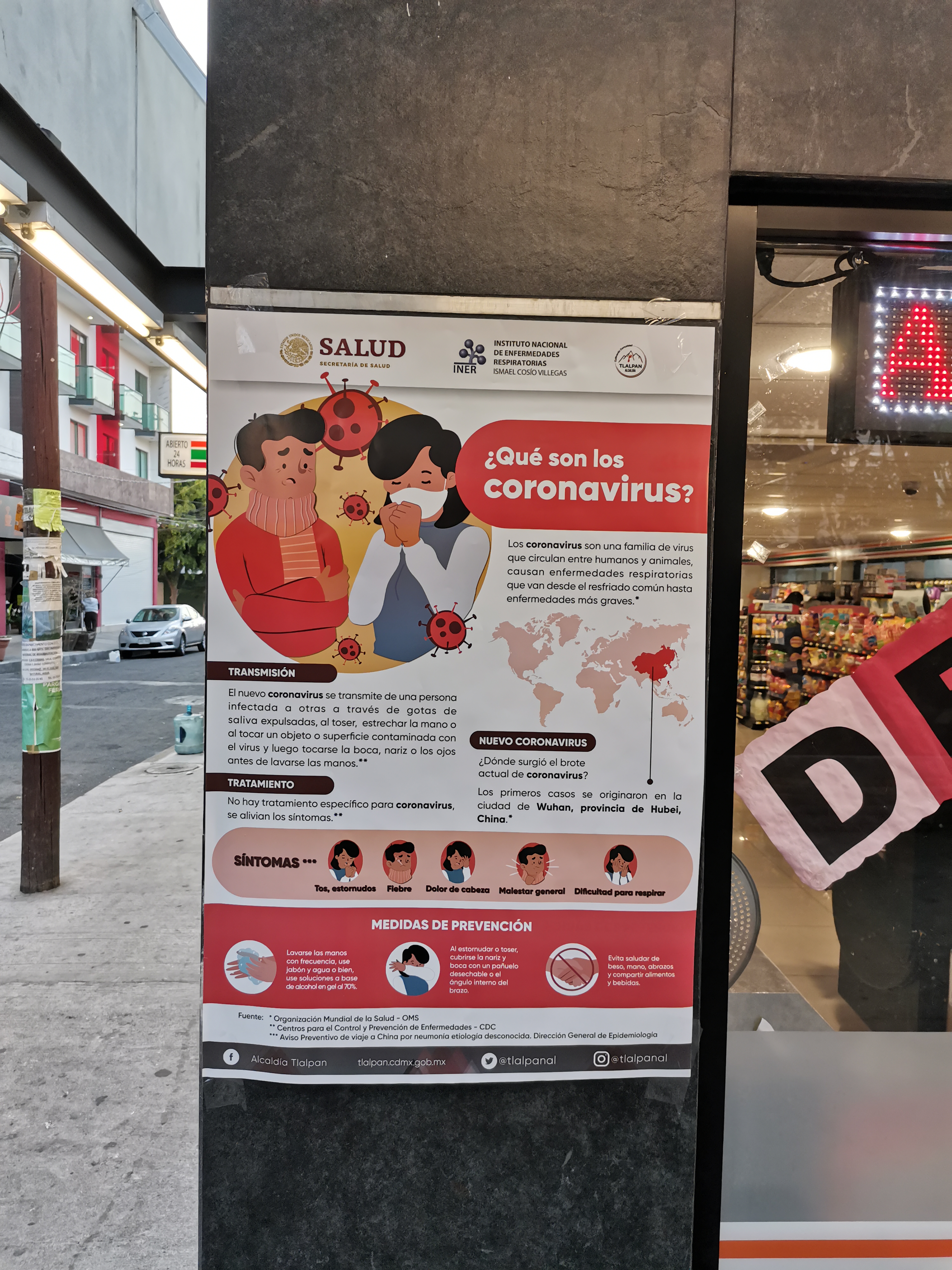
COVID-19 guidelines poster in the surroundings of Instituto Nacional de Ciencias Médicas y Nutrición Salvador Zubirán.
Summary[edit]
| Description |
English: COVID-19 guidelines poster in the surroundings of Instituto Nacional de Ciencias Médicas y Nutrición Salvador Zubirán.
Español: Cartel de pautas COVID-19 en los alrededores del Instituto Nacional de Ciencias Médicas y Nutrición Salvador Zubirán. |
| Date | |
| Source | Own work |
| Author | ProtoplasmaKid |
| Camera location | | View this and other nearby images on: OpenStreetMap |
|---|
Licensing[edit]
- Object
-

This file is licensed under the Licencia de Gobierno Abierto de la Ciudad de México(Mexico City Open Government License).In accordance to Article 2 and Paragraph 2 of Article 3 of the Law of Transparency Access to Public Information and Accountability of Mexico City, all works (other than classified works) made by various agencies of the Mexico City Government are released under this license.
Attribution: Gobierno de la Ciudad de México - You are free to:
- Use the data and content for public or private purposes.
- Copy, modify, make derivative works, publish, adapt, translate, and perform any other activity that involves the transformation of data or content to any format.
- Share and distribute content and data by any electronic or physical means with third parties.
- Exploit the data and content in any way, even commercially.
- With the requirement that you:
- Attribute the origin of the content and data to the Government of Mexico City and, when possible, provide a link to this license.
- You must refrain from:
- Falsifying the information or manipulating it maliciously, in a way that shows erroneous facts or facts contrary to what the data itself shows.
- Using the data and content to violate any national or international law or the rights of third parties.
- In those aspects not provided for in this license, it shall be understood that it is, for international purposes, equivalent to a Creative Commons Attribution 4.0 International license.
- You are free to:
- Photograph
- I, the copyright holder of this work, hereby publish it under the following license:


 This file is licensed under the Creative Commons Attribution-Share Alike 4.0 International license.
- You are free:
- to share – to copy, distribute and transmit the work
- to remix – to adapt the work
- Under the following conditions:
- attribution – You must give appropriate credit, provide a link to the license, and indicate if changes were made. You may do so in any reasonable manner, but not in any way that suggests the licensor endorses you or your use.
- share alike – If you remix, transform, or build upon the material, you must distribute your contributions under the same or compatible license as the original.
- You are free:
File history
Click on a date/time to view the file as it appeared at that time.
| Date/Time | Thumbnail | Dimensions | User | Comment | |
|---|---|---|---|---|---|
| current | 22:44, 24 March 2020 | | 6,000 × 8,000 (8.68 MB) | ProtoplasmaKid (talk | contribs) | Uploaded own work with UploadWizard |
You cannot overwrite this file.
File usage on Commons
There are no pages that use this file.