File:CFL Network 2009.svg
Jump to navigation
Jump to search

Size of this PNG preview of this SVG file: 400 × 490 pixels. Other resolutions: 196 × 240 pixels | 392 × 480 pixels | 627 × 768 pixels | 836 × 1,024 pixels | 1,672 × 2,048 pixels.
Original file (SVG file, nominally 400 × 490 pixels, file size: 171 KB)
Captions
Captions
Add a one-line explanation of what this file represents
| Description |
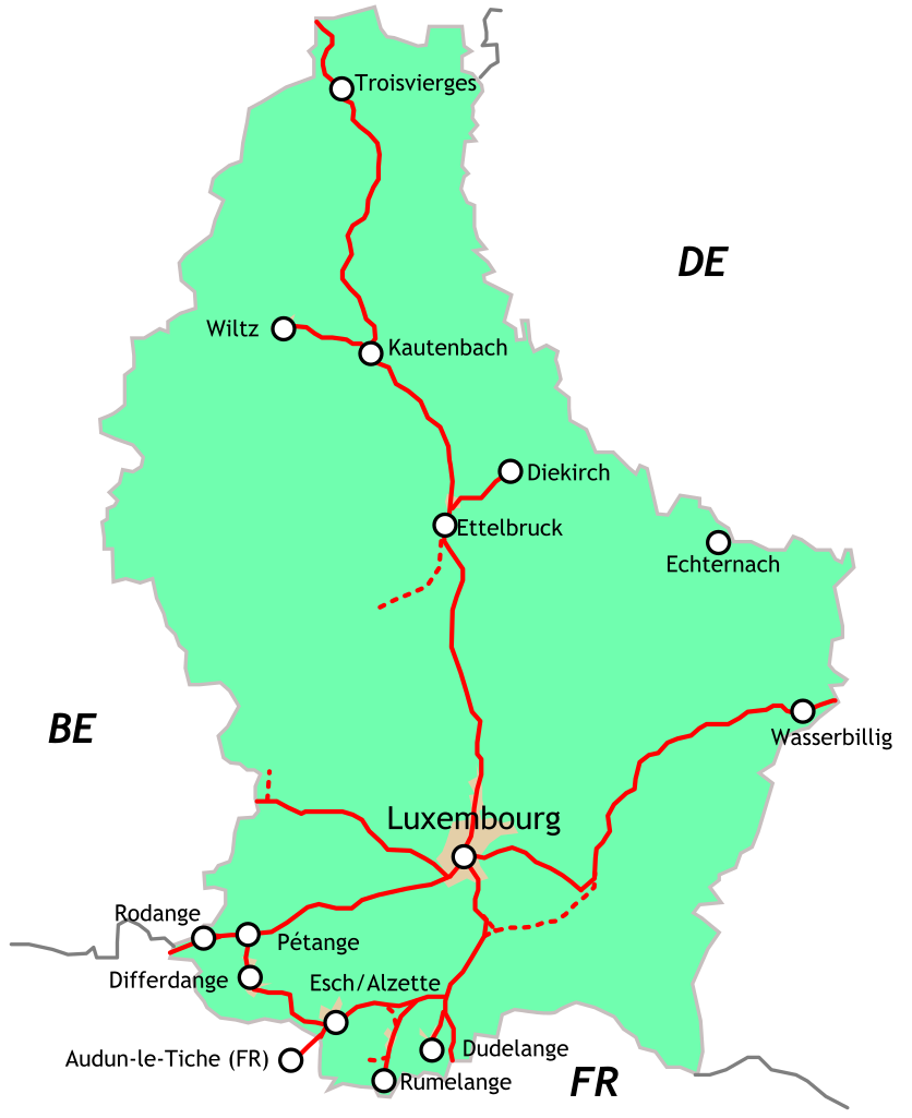
Deutsch: Streckennetz der luxemburgischen Eisenbahn im Jahr 2009 (mit französischen Namen der Bahnhöfe/Städte).
English: Outline map railway network Luxembourg |
| Date | (UTC) |
| Source | |
| Author |
|
| This is a retouched picture, which means that it has been digitally altered from its original version. Modifications: Added some important stations and labels. The original can be viewed here: Map - railways - LU.svg:
|
I, the copyright holder of this work, hereby publish it under the following licenses:
This file is licensed under the Creative Commons Attribution-Share Alike 2.5 Generic, 2.0 Generic and 1.0 Generic license.
- You are free:
- to share – to copy, distribute and transmit the work
- to remix – to adapt the work
- Under the following conditions:
- attribution – You must give appropriate credit, provide a link to the license, and indicate if changes were made. You may do so in any reasonable manner, but not in any way that suggests the licensor endorses you or your use.
- share alike – If you remix, transform, or build upon the material, you must distribute your contributions under the same or compatible license as the original.

|
Permission is granted to copy, distribute and/or modify this document under the terms of the GNU Free Documentation License, Version 1.2 or any later version published by the Free Software Foundation; with no Invariant Sections, no Front-Cover Texts, and no Back-Cover Texts. A copy of the license is included in the section entitled GNU Free Documentation License. |
| This file is licensed under the Creative Commons Attribution-Share Alike 3.0 Unported license. | ||
| ||
| This licensing tag was added to this file as part of the GFDL licensing update. |
You may select the license of your choice.
Original upload log[edit]
This image is a derivative work of the following images:
- File:Map_-_railways_-_LU.svg licensed with Cc-by-sa-2.5,2.0,1.0, GFDL
- 2009-05-11T22:34:46Z Pbech 400x490 (30057 Bytes) Added some railways that still exist but were not on the original map, including the railway from Ettlbruck to Diekirch
- 2007-08-15T18:38:49Z Michiel1972 400x490 (23531 Bytes) == Summary == {{Information |Description=Ouline map railway network Luxemburg |Source=self-made |Date= |Author= [[User:Michiel1972|Michiel1972]] }} [[Category:Maps of Luxembourg]] == Licensing == {{self|GFDL|cc-by-sa-2.5,2.0
Uploaded with derivativeFX
File history
Click on a date/time to view the file as it appeared at that time.
| Date/Time | Thumbnail | Dimensions | User | Comment | |
|---|---|---|---|---|---|
| current | 20:43, 7 June 2009 | | 400 × 490 (171 KB) | Pbech (talk | contribs) | Changed line Luxembourg - Oetrange to goods-only line |
| 23:06, 11 May 2009 |  | 400 × 490 (171 KB) | Pbech (talk | contribs) | {{Information |Description=Outline map railway network Luxembourg |Source=*File:Map_-_railways_-_LU.svg |Date=2009-05-12 00:05 (UTC) |Author=*File:Map_-_railways_-_LU.svg: Michiel1972 *derivative work: ~~~ |Permission=see |
You cannot overwrite this file.
File usage on Commons
The following 2 pages use this file:
File usage on other wikis
The following other wikis use this file:
- Usage on ca.wikipedia.org
- Usage on cs.wikipedia.org
- Usage on da.wikipedia.org
- Usage on de.wikivoyage.org
- Usage on el.wikipedia.org
- Usage on it.wikipedia.org
- Usage on www.wikidata.org
- Usage on zh.wikipedia.org