File:Buurtspoorwegen Namen.png
Jump to navigation
Jump to search

Size of this preview: 634 × 599 pixels. Other resolutions: 254 × 240 pixels | 508 × 480 pixels | 812 × 768 pixels | 1,083 × 1,024 pixels | 1,939 × 1,833 pixels.
Original file (1,939 × 1,833 pixels, file size: 1.8 MB, MIME type: image/png)
Captions
Captions
Add a one-line explanation of what this file represents
Summary[edit]
| Description |
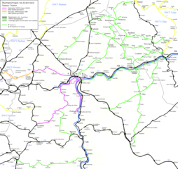
English: Map off the vicinal railways in the province off Namur.
Nederlands: Kaart van de buurtspoorwegen in de provincie Namen. |
| Date | |
| Source | Own work |
| Author | Smiley.toerist |
Licensing[edit]
I, the copyright holder of this work, hereby publish it under the following licenses:

|
Permission is granted to copy, distribute and/or modify this document under the terms of the GNU Free Documentation License, Version 1.2 or any later version published by the Free Software Foundation; with no Invariant Sections, no Front-Cover Texts, and no Back-Cover Texts. A copy of the license is included in the section entitled GNU Free Documentation License. |
This file is licensed under the Creative Commons Attribution-Share Alike 3.0 Unported, 2.5 Generic, 2.0 Generic and 1.0 Generic license.
- You are free:
- to share – to copy, distribute and transmit the work
- to remix – to adapt the work
- Under the following conditions:
- attribution – You must give appropriate credit, provide a link to the license, and indicate if changes were made. You may do so in any reasonable manner, but not in any way that suggests the licensor endorses you or your use.
- share alike – If you remix, transform, or build upon the material, you must distribute your contributions under the same or compatible license as the original.
You may select the license of your choice.
File history
Click on a date/time to view the file as it appeared at that time.
| Date/Time | Thumbnail | Dimensions | User | Comment | |
|---|---|---|---|---|---|
| current | 20:23, 7 August 2022 | | 1,939 × 1,833 (1.8 MB) | Arflhn (talk | contribs) | Waremme Omal was 470 |
| 20:03, 20 October 2010 |  | 1,939 × 1,833 (1.48 MB) | Smiley.toerist (talk | contribs) | Routes bijgewerkt aan de hand van oude kaart gegevens. Andenne en Statte zijn aangepast. | |
| 14:45, 9 April 2010 |  | 1,939 × 1,833 (1.48 MB) | Smiley.toerist (talk | contribs) | ||
| 19:44, 7 April 2010 |  | 1,939 × 1,833 (1.48 MB) | Smiley.toerist (talk | contribs) | ||
| 12:11, 29 March 2010 |  | 1,939 × 1,833 (1.47 MB) | Smiley.toerist (talk | contribs) | ||
| 19:14, 30 November 2009 |  | 1,939 × 1,833 (1.47 MB) | Smiley.toerist (talk | contribs) | ||
| 20:13, 26 November 2009 |  | 1,939 × 1,833 (1.46 MB) | Smiley.toerist (talk | contribs) | ||
| 20:07, 19 November 2009 |  | 1,939 × 1,833 (1.39 MB) | Smiley.toerist (talk | contribs) | ||
| 21:07, 13 November 2009 |  | 1,939 × 1,833 (1.49 MB) | Smiley.toerist (talk | contribs) | {{Information |Description={{en|1=Map off the vicinal railways in the province off Namur. In construction!}} {{nl|1=Kaart van de buurtspoorwegen in de provincie Namen. In bouw!}} |Source={{own}} |Author=Smiley.toerist |Date=2009-11 |
You cannot overwrite this file.
File usage on Commons
The following 4 pages use this file:
File usage on other wikis
The following other wikis use this file:
- Usage on cs.wikipedia.org
- Usage on fr.wikipedia.org
- Société nationale des chemins de fer vicinaux
- Lignes de tramway de la SNCV dans la province de Namur
- Utilisateur:Arflhn/Brouillon 5
- Ligne de tramway 556 Dinant Grottes - Florennes-Central
- Ligne de tramway 10 (SNCV Groupe de Namur)
- Ligne de tramway 9 (SNCV Groupe de Namur)
- Ligne de tramway 8 (SNCV Groupe de Namur)
- Ligne de tramway 7 (SNCV Groupe de Namur)
- Ligne de tramway 5 (SNCV Groupe de Namur)
- Ligne de tramway 3 (SNCV Groupe de Namur)
- Ligne de tramway 6 (SNCV Groupe de Namur)
- Ligne de tramway 539/2
- Ligne de tramway 544/1
- Ligne de tramway 530A
- Ligne de tramway 530B
- Ligne de tramway 525
- Ligne de tramway 572B
- Ligne de tramway 572A
- Ligne de tramway 546
- Usage on nl.wikipedia.org