File:Bomb damage map of the Metropolitan Borough of Hampstead, c. 1946.jpg
Jump to navigation
Jump to search

Size of this preview: 800 × 547 pixels. Other resolutions: 320 × 219 pixels | 640 × 438 pixels | 1,024 × 700 pixels | 1,280 × 875 pixels | 2,560 × 1,751 pixels | 3,457 × 2,364 pixels.
Original file (3,457 × 2,364 pixels, file size: 1.25 MB, MIME type: image/jpeg)
Captions
Captions
Add a one-line explanation of what this file represents
Summary[edit]
| Description |
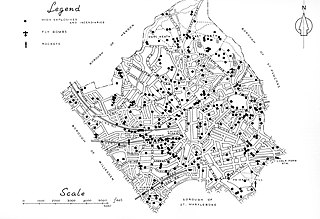
English: Bomb map of the Metropolitan Borough of Hampstead, c. 1946 |
| Date | circa 1946 |
| Source | Hampstead at War, 1939-45, Metropolitan Borough of Hampstead, pp. 20-21 |
| Author | Metropolitan Borough of Hampstead |
Licensing[edit]
This work created by the United Kingdom Government is in the public domain.
This is because it is one of the following:
HMSO has declared that the expiry of Crown Copyrights applies worldwide (ref: HMSO Email Reply)
|
 |
File history
Click on a date/time to view the file as it appeared at that time.
| Date/Time | Thumbnail | Dimensions | User | Comment | |
|---|---|---|---|---|---|
| current | 19:53, 10 September 2022 | | 3,457 × 2,364 (1.25 MB) | Isochrone (talk | contribs) | Uploaded a work by {{w|Metropolitan Borough of Hampstead}} from ''Hampstead at War, 1939-45'', {{w|Metropolitan Borough of Hampstead}}, pp. 20-21 with UploadWizard |
You cannot overwrite this file.
File usage on Commons
There are no pages that use this file.