File:BlankMapTurkishProvincesRegions.svg

Original file (SVG file, nominally 1,052 × 744 pixels, file size: 189 KB)
Captions
Captions
Summary[edit]
| Description |
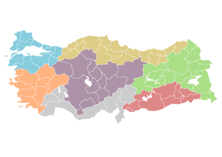
Map of Republic of Turkey's provinces, with regions separated by color. Each entity holds name of province and ISO 3166 code information. The original map is available as Image:BlankMapTurkeyProvinces.png. The author gave the following information: Description=Blank map of Republic of Turkey's provinces. The regions are carefully separated on per pixel basis and ready for filling in with a paint tool. Couleurs (légende)
Source=Self drawn from scratch, based on data from official Turkish motorway network map Date=December 21, 2006 Author=Atilim Gunes Baydin Permission=I grant permission for anyone to use this under the terms of GFDL license, see below |
| Date | 21 December 2006 (original upload date) |
| Source | Originally from commons.wikipedia; description page is/was here. |
| Author |
Modifications made by user User:Hk_kng at commons.wikipedia Original uploader was AtilimGunesBaydin at commons.wikipedia |
| Permission (Reusing this file) |
Released under the GNU Free Documentation License; Licensed under the GFDL by the author. |
Original upload log[edit]
(All user names refer to commons.wikipedia)
- 2007-02-18 22:14 AtilimGunesBaydin 1024×500×8 (23317 bytes) Removed Samothraki, which was accidentally included. I'm sorry for the mistake.
- 2006-12-22 16:46 AtilimGunesBaydin 1024×500×8 (23347 bytes) Slight resize.
- 2006-12-21 21:51 AtilimGunesBaydin 1024×499×8 (23338 bytes) {{Information |Description=Blank map of [[:en:Turkey|Republic of Turkey]]'s provinces |Source=Drawn from scratch on based on data from [http://www.kgm.gov.tr/images/trkh-yeni1.jpg official Turkish motorway network map] |Date=December 21, 2006 |Author=[[:e
Licensing[edit]

|
Permission is granted to copy, distribute and/or modify this document under the terms of the GNU Free Documentation License, Version 1.2 or any later version published by the Free Software Foundation; with no Invariant Sections, no Front-Cover Texts, and no Back-Cover Texts. A copy of the license is included in the section entitled GNU Free Documentation License. |
| This file is licensed under the Creative Commons Attribution-Share Alike 3.0 Unported license. | ||
| ||
| This licensing tag was added to this file as part of the GFDL licensing update. |
File history
Click on a date/time to view the file as it appeared at that time.
| Date/Time | Thumbnail | Dimensions | User | Comment | |
|---|---|---|---|---|---|
| current | 02:21, 9 April 2007 | | 1,052 × 744 (189 KB) | Hk kng (talk | contribs) | {{Information |Description=''no original description'' |Source=Originally from [http://en.wikipedia.org en.wikipedia]; description page is/was [http://en.wikipedia.org/w/index.php?title=Image%3ABlankMapTurkeyProvinces.png here]. |Date= (original upload da |
You cannot overwrite this file.
File usage on Commons
The following 3 pages use this file:
File usage on other wikis
The following other wikis use this file:
- Usage on ca.wikipedia.org
- Usage on de.wikipedia.org
- Usage on fr.wikipedia.org
- Projet:Géographie/Palettes de navigation
- Hatay
- Sakarya (province)
- Denizli (province)
- Kocaeli (province)
- Afyonkarahisar (province)
- Modèle:Palette Provinces de Turquie
- Adana (province)
- Adıyaman (province)
- Ağrı (province)
- Aksaray (province)
- Amasya (province)
- Ankara (province)
- Antalya (province)
- Ardahan (province)
- Artvin (province)
- Aydın (province)
- Balıkesir (province)
- Bartın (province)
- Batman (province)
- Bayburt (province)
- Bilecik (province)
- Bingöl (province)
- Bitlis (province)
- Bolu (province)
- Burdur (province)
- Bursa (province)
- Çanakkale (province)
- Çankırı (province)
- Çorum (province)
- Diyarbakır (province)
- Düzce (province)
- Edirne (province)
- Elâzığ (province)
- Erzincan (province)
- Erzurum (province)
- Eskişehir (province)
- Gaziantep (province)
- Giresun (province)
- Gümüşhane (province)
- Hakkari (province)
- Iğdır (province)
- Isparta (province)
- Istanbul (province)
- İzmir (province)
- Kahramanmaraş (province)
- Karabük (province)
- Karaman (province)
View more global usage of this file.