File:Blaeu Africae Nova Descriptio 1617 UTA.jpg
Original file (6,810 × 5,031 pixels, file size: 16.44 MB, MIME type: image/jpeg)
Captions
Captions
Summary[edit]
| Title |
Latina: Africae Nova Descriptio |
||||||||||||||||||||||||||
| Description |
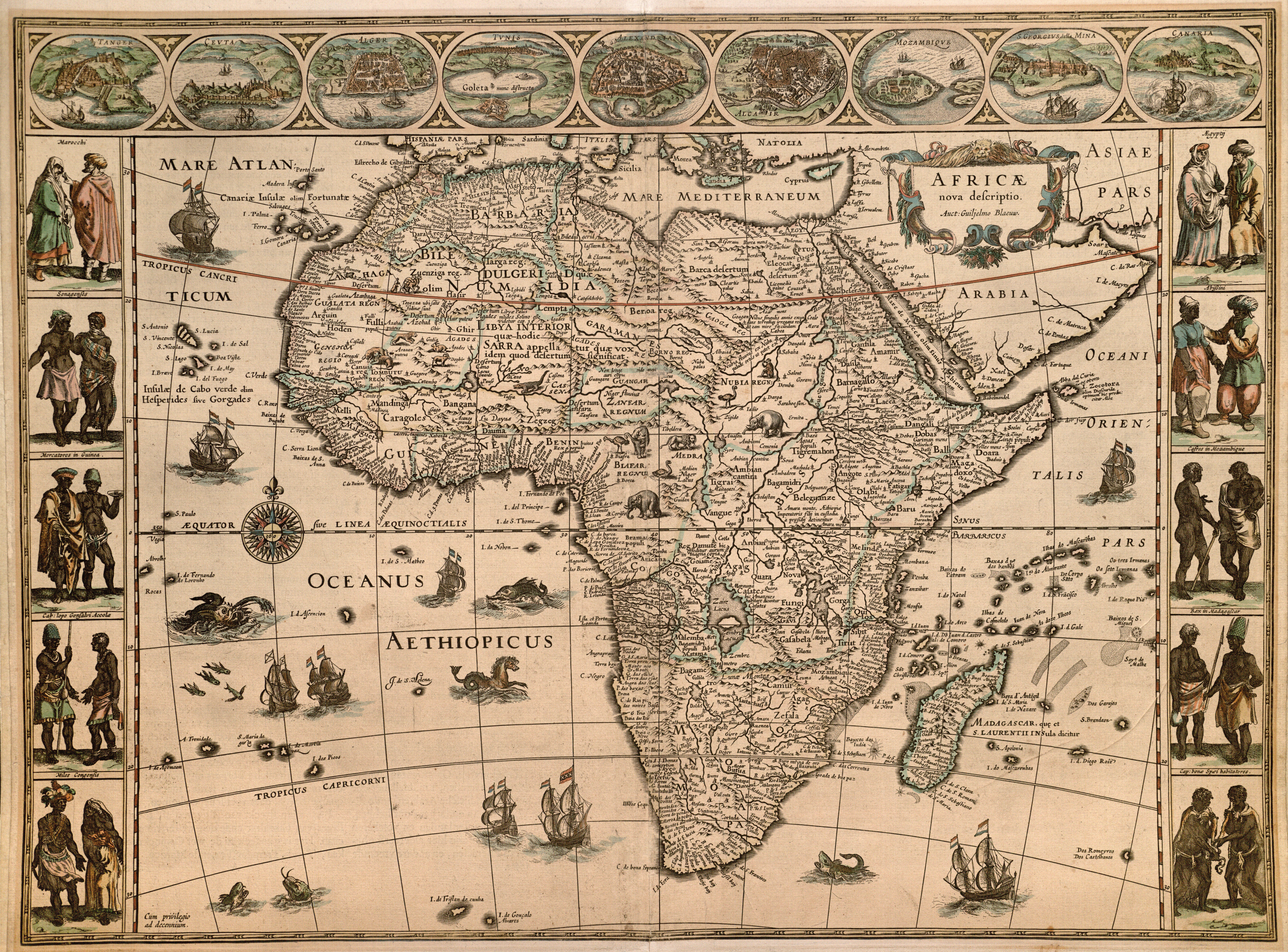
English: Among the more important cartographers and map publishers of the Dutch Baroque or Golden Age, Willem Jansz. Blaeu (1571-1638), along with his sons Joan (ca.1599-1673) and Cornelis (1610-1644), created highly sought-for maps, atlases, and globes of considerable artistic refinement. A former pupil of the Danish astronomer Tycho Brahe, Willem based this map indirectly on Hondius' 1606 map of Africa which had been a source for his own landmark 1608 wall map of Africa (engraved by Josua van den Ende) which in turn served as a model for many other competitors. Around the border Blaeu has added illustrations of Tangier, Ceuta, Algiers, Tunis, Alexandria, Cairo, Mozambique, Elmina, and the Canary Islands. The figures in traditional dress include Moroccans, Senegalese, merchants in Guinea, inhabitants of Cabo Lopo Goncalves, Congolese warriors, Egyptians, Abyssinians, Kaffirs in Mozambique, the king of Madagascar and the inhabitants of the Cape of Good Hope. Blaeu's maps also introduced many more animals, sea monsters, and ships (most of them Dutch). Incidentally, one of the designers of the wall map had been Hessel Gerritsz, who served from 1617 as the official cartographer for the Dutch East India Company (VOC) until his death in 1632, when Willem took over, serving in that capacity until his death six years later. Willem's son Joan and grandson Joan II also served in this position, but the VOC also patronized their lesser-priced competitors. |
||||||||||||||||||||||||||
| Date | |||||||||||||||||||||||||||
| Source | UTA Libraries Cartographic Connections: map / text | ||||||||||||||||||||||||||
| Creator |
|
||||||||||||||||||||||||||
| Credit line |
English: UTA Libraries Special Collections, Gift of Dr. Jack Franke |
||||||||||||||||||||||||||
| Geotemporal data | |||||||||||||||||||||||||||
| Map location | Africa | ||||||||||||||||||||||||||
| Georeferencing | If inappropriate please set warp_status = skip to hide. | ||||||||||||||||||||||||||
| Bibliographic data | |||||||||||||||||||||||||||
| Place of publication | Amsterdam | ||||||||||||||||||||||||||
| Printed by |
|
||||||||||||||||||||||||||
| Archival data | |||||||||||||||||||||||||||
| Collection |
|
||||||||||||||||||||||||||
| Dimensions | height: 41 cm (16.1 in); width: 55.5 cm (21.8 in) | ||||||||||||||||||||||||||
| Medium | colored engraving on paper | ||||||||||||||||||||||||||
| artwork-references |
Betz (2007) The Mapping of Africa, 214−219, 225−228 Schilder (1986) Monumenta Cartographica VI, 116−119 van der Krogt, Peter (2006) Joan Blaeu Atlas Maior "The Greatest and Finest Atlas Ever Published", Cologne: Benedikt Taschen, pp. 314−317 Goss, John (1990) Blaeu's the Grand Atlas of the 17th-Century World, New York City: Rizzoli, pp. 140−141 |
||||||||||||||||||||||||||

Licensing[edit]

|
This file was provided to Wikimedia Commons by the University of Texas at Arlington Libraries as part of a cooperation project. The University of Texas at Arlington Libraries is part of the University of Texas at Arlington, a public research university located in Arlington, Texas.
|
|
The author died in 1638, so this work is in the public domain in its country of origin and other countries and areas where the copyright term is the author's life plus 100 years or fewer. This work is in the public domain in the United States because it was published (or registered with the U.S. Copyright Office) before January 1, 1929. | |
| This file has been identified as being free of known restrictions under copyright law, including all related and neighboring rights. | |
File history
Click on a date/time to view the file as it appeared at that time.
| Date/Time | Thumbnail | Dimensions | User | Comment | |
|---|---|---|---|---|---|
| current | 15:49, 23 December 2021 | | 6,810 × 5,031 (16.44 MB) | Michael Barera (talk | contribs) | == {{int:filedesc}} == {{Map |title = ''Africae Nova Descriptio'' |description = {{en|Among the more important cartographers and map publishers of the Dutch Baroque or Golden Age, Willem Jansz. Blaeu (1571-1638), along with his sons Joan (ca.1599-1673) and Cornelis (1610-1644), created highly sought-for maps, atlases, and globes of considerable artistic refinement. A former pupil of the Danish astronomer Tycho Brahe, Willem based this map indirectly on Hondius' 1606 map of... |
You cannot overwrite this file.
File usage on Commons
The following page uses this file:
File usage on other wikis
The following other wikis use this file:
- Usage on de.wikipedia.org
- Usage on nl.wikipedia.org
- Usage on sv.wikipedia.org