File:Bixby Creek Bridge, California, USA - May 2013.jpg
Jump to navigation
Jump to search

Size of this preview: 800 × 396 pixels. Other resolutions: 320 × 159 pixels | 640 × 317 pixels | 1,024 × 507 pixels | 1,280 × 634 pixels | 2,560 × 1,268 pixels | 6,488 × 3,214 pixels.
Original file (6,488 × 3,214 pixels, file size: 7.84 MB, MIME type: image/jpeg)
Captions
Captions
Add a one-line explanation of what this file represents
|
Summary[edit]
| Description |
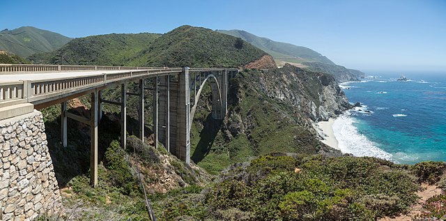
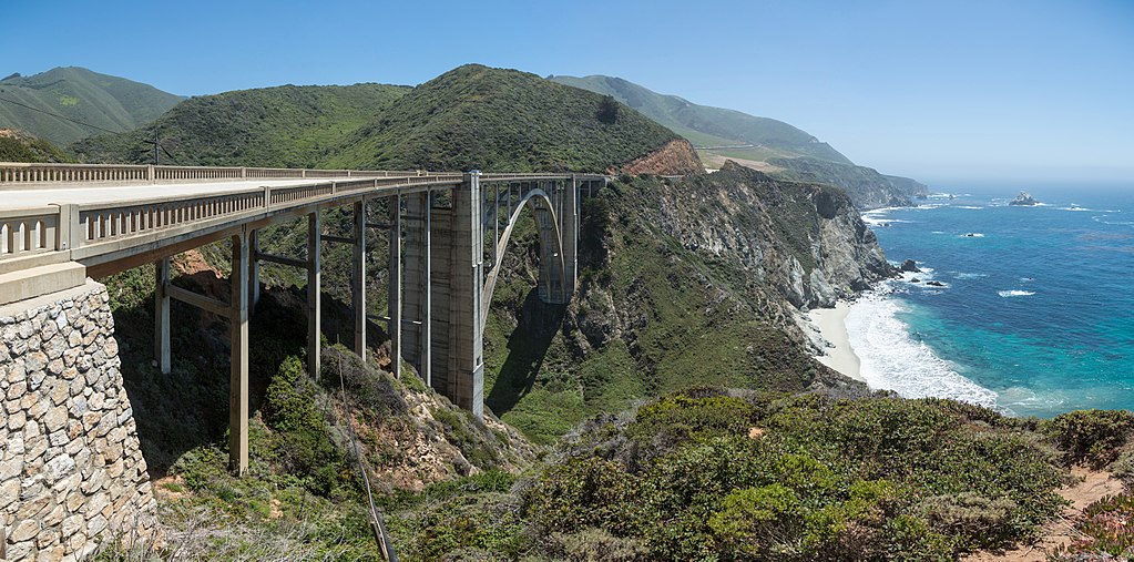
English: Bixby Creek Bridge, viewed from the northern side near Big Sur on the Central Californian Coast in the United States. |
| Date | |
| Source | Own work |
| Author | Diliff |
| Permission (Reusing this file) |
Summary:In using this image or any subsequent derivatives of it, you are required to release the image under the same license. As such, any reproduction of this image, in any medium, must appear with a copy of, or full URL of the license.Attribution of this image to the author (DAVID ILIFF) is also required, preferably in a prominent location near the image.No other conditions may be added to, or removed from this license without the permission of the author and copyright holder.Suggested attribution: "Photo by DAVID ILIFF. License: CC BY-SA 3.0"Please review the full license requirements carefully before using this image. If you would like to clarify the terms of the license or negotiate less restrictive commercial licensing outside of the bounds of GFDL/CC-BY-SA, please contact me by email, or if you don't have a Wikipedia account you can either leave a message on my talk page with your contact details and your request, or you can contact me on Facebook. Please also send a 'friend request' to ensure that I am aware of your message. |
| Other versions |


| Camera location | | View this and other nearby images on: OpenStreetMap |
|---|
Licensing[edit]
I, the copyright holder of this work, hereby publish it under the following licenses:
This file is licensed under the Creative Commons Attribution-Share Alike 3.0 Unported license.
- You are free:
- to share – to copy, distribute and transmit the work
- to remix – to adapt the work
- Under the following conditions:
- attribution – You must give appropriate credit, provide a link to the license, and indicate if changes were made. You may do so in any reasonable manner, but not in any way that suggests the licensor endorses you or your use.
- share alike – If you remix, transform, or build upon the material, you must distribute your contributions under the same or compatible license as the original.

|
Permission is granted to copy, distribute and/or modify this document under the terms of the GNU Free Documentation License, Version 1.2 or any later version published by the Free Software Foundation; with no Invariant Sections, no Front-Cover Texts, and no Back-Cover Texts. A copy of the license is included in the section entitled GNU Free Documentation License. |
You may select the license of your choice.
File history
Click on a date/time to view the file as it appeared at that time.
| Date/Time | Thumbnail | Dimensions | User | Comment | |
|---|---|---|---|---|---|
| current | 09:38, 30 August 2017 | | 6,488 × 3,214 (7.84 MB) | Nikhil B (talk | contribs) | Reverted to version as of 06:34, 28 May 2013 (UTC) |
| 08:26, 18 June 2017 |  | 1,920 × 951 (770 KB) | Dpalma01 (talk | contribs) | Color corrected file. | |
| 06:34, 28 May 2013 |  | 6,488 × 3,214 (7.84 MB) | Diliff (talk | contribs) | {{Information |Description ={{en|1=Bixby Creek Bridge, viewed from the northern side near Big Sur on the Central Californian Coast in the United States.}} |Source ={{own}} |Author =Diliff |Date =2013-05-20 |... |
You cannot overwrite this file.
File usage on Commons
The following 21 pages use this file:
- Bixby Creek Bridge
- User:Miya/POTY/2014
- User:Ö/Best/2014
- User talk:Diliff/Archive3
- Commons:Featured picture candidates/File:Bixby Creek Bridge, California, USA - May 2013.jpg
- Commons:Featured picture candidates/Log/December 2014
- Commons:Featured pictures/Places/Architecture/Bridges
- Commons:Featured pictures/chronological/2014-B
- Commons:Files used on the AARoads Wiki/8
- Commons:Picture of the Year/2014/Candidates
- Commons:Picture of the Year/2014/R1/Gallery/2014-B
- Commons:Picture of the Year/2014/R1/Gallery/ALL
- Commons:Picture of the Year/2014/R1/Gallery/Infrastructure
- Commons:Picture of the Year/2014/R1/Gallery/M12
- Commons:Picture of the Year/2014/R1/Results/Candidates
- Commons:Picture of the Year/2014/R1/Results/Candidates/Infrastructure
- Commons:Picture of the Year/2014/R1/Results/Infrastructure
- Commons:Picture of the Year/2014/R1/v/Bixby Creek Bridge, California, USA - May 2013.jpg
- File:California Hebrew Wikivoyage front page banner.jpg
- File:California Rte 1 banner.jpg
- File:Monterey county banner Bixby Creek Bridge.jpg
File usage on other wikis
The following other wikis use this file:
- Usage on de.wikivoyage.org
- Usage on en.wikipedia.org
- California State Route 1
- Wikipedia:WikiProject U.S. Roads/California
- Bixby Bridge
- User:Diliff
- Wikipedia:Featured pictures/Places/Architecture
- Talk:Bixby Bridge
- Portal:Architecture/Travel images
- List of state highways in California
- Wikipedia:WikiProject U.S. Roads/Recognized content
- Wikipedia:WikiProject U.S. Roads/California/Recognized content
- Wikipedia:WikiProject U.S. Roads/Main page content
- Wikipedia:Featured pictures thumbs/39
- User:EuroCarGT/Possible FPC
- Wikipedia:Featured picture candidates/Bixby Creek Bridge
- Wikipedia:Featured picture candidates/February-2014
- User talk:EuroCarGT/Archives/2014/February
- User talk:Diliff/Archive12
- Wikipedia:Picture of the day/December 2015
- Template:POTD/2015-12-26
- User talk:EuroCarGT/Archives/2015/December
- Wikipedia:Main Page history/2015 December 26
- User talk:Diliff/Archive14
- User:Tv's emory/Sandbox/List of state highways in California
- Wikipedia:WikiProject U.S. Roads/State highways
- Wikipedia:WikiProject U.S. Roads/State highways/Recognized content
- Big Sur Coast Highway
- Portal:The arts/Recognized content
- Portal:Architecture/Recognized content
- Usage on fa.wikipedia.org
- ویکیپدیا:نگارههای برگزیده/جاها/معماری
- ویکیپدیا:گزیدن نگاره برگزیده/مقالههای ناموجود/پیشنهادی
- ویکیپدیا:نگاره روز/مارس ۲۰۲۴
- ویکیپدیا:گزیدن نگاره برگزیده/اوت-۲۰۲۳
- بحث کاربر:Behnam mancini/بایگانی ۳
- ویکیپدیا:گزیدن نگاره برگزیده/Bixby Creek Bridge, California, USA - May 2013.jpg
- پل بیکسبی
- الگو:نر/2024-03-30
- الگو:نر محافظت شده/2024-03-30
- Usage on fr.wikipedia.org
- Usage on ha.wikipedia.org
- Usage on he.wikipedia.org
- Usage on he.wikivoyage.org
- Usage on it.wikipedia.org
- Usage on ka.wikipedia.org
- Usage on ko.wikipedia.org
- Usage on mg.wikipedia.org
- Usage on pl.wikipedia.org
View more global usage of this file.