File:Bird's Eye View of the Land of Lakes.jpg

Original file (1,401 × 1,990 pixels, file size: 291 KB, MIME type: image/jpeg)
Captions
Captions
Summary[edit]
| Description |
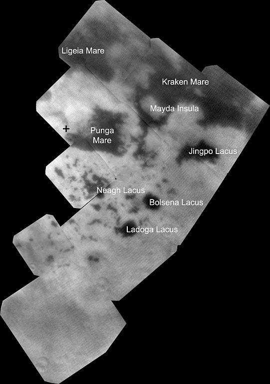
English: The vast hydrocarbon seas and lakes (dark shapes) near the north pole of Saturn's moon Titan sprawl out beneath the watchful eye of NASA's Cassini spacecraft. Scientists are studying images like these for clues about how Titan's hydrocarbon lakes formed. Titan is the only world other than Earth that is known to have stable bodies of liquid on its surface.
This view was made from near-infrared images of Titan obtained by Cassini's imaging science subsystem. Bright material seems to surround the lakes, which could help explain why currently almost all large bodies of liquid are found here, at Titan's north pole, rather than other parts of Titan. The imaging data suggest the surface here is unique. Explanations range from the collapse of land after a volcanic eruption to karst terrain, where liquids dissolve soluble bedrock. Karst terrains on Earth can create spectacular topography such as the Carlsbad Caverns in New Mexico The largest of the dark shapes, at the upper right, is Kraken Mare, Titan's largest sea and about the size of the Caspian Sea and Lake Superior put together. To its left lies Ligeia Mare (about 300 miles or 500 kilometers across), the second largest sea. Punga Mare (about 240 miles or 380 kilometers across) is below Ligeia Mare and just above its leftmost finger is the north pole. Other shades of grey are surface features, primarily within the bright polar surface area identified in images taken during the two previous Titan flybys (PIA17471 and PIA17472). An unannotated version is available that also labels other nearby lakes. The near-infrared images that make up this mosaic were obtained by Cassini's imaging science subsystem on Sept. 12, 2013. They were obtained in the near infrared band of light (938 nanometers), close to the visible range of light that human eyes can see. To human eyes, the lakes would still appear darker than the surrounding terrain. To maximize signal from Titan's surface through the hazy atmosphere, 10 image footprints (with four images per footprint) were combined. The terrain visible in this image is about 1,000 miles (2,000 kilometers) from top to bottom. Image scale is 1,760 feet (536 meters) per pixel. Until now, Cassini's imaging science subsystem has only been able to capture distant, oblique or partial views of this area (e.g., PIA08930 and PIA12812). Three recent flybys provided better viewing geometry now that sunlight has pierced the winter darkness that shrouded Titan's north pole at the time of Cassini's arrival in the Saturn system nine years ago. A thick cap of haze that once hung over the north pole has also dissipated as northern summer approaches. And, thankfully, Titan's beautiful, almost cloudless, rain-free weather continued during Cassini's flybys this past summer. For comparison, Cassini's visual and infrared spectrometer also obtained data on the same area around the same time: PIA17470. Other imaging camera views can be seen at PIA17471 and PIA17472. The Cassini-Huygens mission is a cooperative project of NASA, the European Space Agency and the Italian Space Agency. The Jet Propulsion Laboratory, a division of the California Institute of Technology, Pasadena, manages the Cassini-Huygens mission for NASA's Science Mission Directorate in Washington. The Cassini orbiter and its two onboard cameras were designed, developed and assembled at JPL. The imaging team consists of scientists from the United States, the United Kingdom, France and Germany. The imaging operations center is based at the Space Science Institute in Boulder, Colo. |
| Date | |
| Source | http://www.nasa.gov/mission_pages/cassini/whycassini/cassini20131023.html |
| Author | NASA/JPL-Caltech/SSI/JHUAPL/Univ. of Arizona |
Licensing[edit]
| This file is in the public domain in the United States because it was solely created by NASA. NASA copyright policy states that "NASA material is not protected by copyright unless noted". (See Template:PD-USGov, NASA copyright policy page or JPL Image Use Policy.) | ||
 |
Warnings:
|
File history
Click on a date/time to view the file as it appeared at that time.
| Date/Time | Thumbnail | Dimensions | User | Comment | |
|---|---|---|---|---|---|
| current | 11:31, 24 October 2013 | | 1,401 × 1,990 (291 KB) | Stas1995 (talk | contribs) | User created page with UploadWizard |
You cannot overwrite this file.
File usage on Commons
The following page uses this file:
File usage on other wikis
The following other wikis use this file:
- Usage on pl.wikipedia.org