File:Bentley Brook 583793 b2b4aa67.jpg
Jump to navigation
Jump to search

Size of this preview: 800 × 449 pixels. Other resolutions: 320 × 180 pixels | 640 × 359 pixels | 1,024 × 575 pixels | 1,280 × 719 pixels | 3,445 × 1,935 pixels.
Original file (3,445 × 1,935 pixels, file size: 1.8 MB, MIME type: image/jpeg)
Captions
Captions
Add a one-line explanation of what this file represents
Summary
[edit]
| Description |
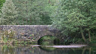
English: Bridge carrying Oaksedge Lane over Bentley Brook (Lower reservoir)
The photograph is of the bridge carrying Oaksedge Lane over Bentley Brook as it enters the reservoir. Return to the photographs of the 583773. |
| Date | |
| Source | From geograph.org.uk |
| Author | Alan Walker |
| Camera location | | View this and other nearby images on: OpenStreetMap |
|---|
Licensing
[edit]

|
This image was taken from the Geograph project collection. See this photograph's page on the Geograph website for the photographer's contact details. The copyright on this image is owned by Alan Walker and is licensed for reuse under the Creative Commons Attribution-ShareAlike 2.0 license.
|
This file is licensed under the Creative Commons Attribution-Share Alike 2.0 Generic license.
Attribution: Alan Walker
- You are free:
- to share – to copy, distribute and transmit the work
- to remix – to adapt the work
- Under the following conditions:
- attribution – You must give appropriate credit, provide a link to the license, and indicate if changes were made. You may do so in any reasonable manner, but not in any way that suggests the licensor endorses you or your use.
- share alike – If you remix, transform, or build upon the material, you must distribute your contributions under the same or compatible license as the original.
File history
Click on a date/time to view the file as it appeared at that time.
| Date/Time | Thumbnail | Dimensions | User | Comment | |
|---|---|---|---|---|---|
| current | 22:29, 27 August 2017 | | 3,445 × 1,935 (1.8 MB) | Geograph Update Bot (talk | contribs) | Higher-resolution version from Geograph. |
| 12:29, 22 February 2008 |  | 640 × 359 (121 KB) | Victuallers (talk | contribs) | {{Information |Description=bridge carrying Oaksedge Lane over Bentley brook in Derbyshire as it enters the lower reservoir. OSGB36: SK 313 607External link [100m precision] WGS84: 53:8.5788N 1:31.9576W |Source=http://www.geograph.org.u |
You cannot overwrite this file.
File usage on Commons
The following page uses this file:
File usage on other wikis
The following other wikis use this file:
- Usage on en.wikipedia.org
- Usage on www.wikidata.org