File:Benrater und Speyrer Linie.png
Jump to navigation
Jump to search

Size of this preview: 498 × 599 pixels. Other resolutions: 199 × 240 pixels | 399 × 480 pixels | 638 × 768 pixels | 851 × 1,024 pixels | 1,673 × 2,013 pixels.
Original file (1,673 × 2,013 pixels, file size: 814 KB, MIME type: image/png)
Captions
Captions
Add a one-line explanation of what this file represents
Summary[edit]
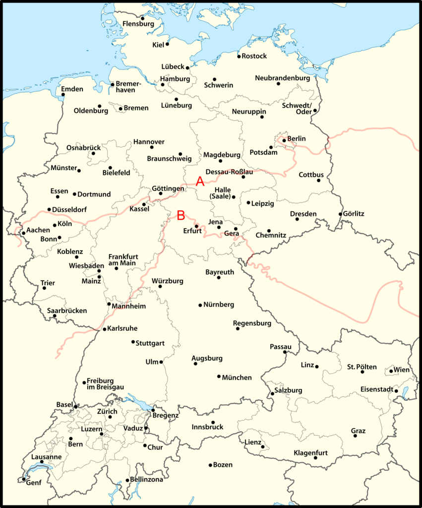
| Description | Darstellungskarte der Benrater (A) und Speyrer Linie (B). |
| Date | |
| Source | Own work, Grundkarte von User NordNordWest (Datei:D-A-CH beschriftet.svg) und SUF: Verteilung und Raumgliederung deutscher und niederländischer Sprache als Mundart der ländlichen Bevölkerung in Mitteleuropa um 1900 (REDE Karten ID 15591) |
| Author | MicBy67 |
Licensing[edit]
I, the copyright holder of this work, hereby publish it under the following license:
This file is licensed under the Creative Commons Attribution-Share Alike 3.0 Unported license.
- You are free:
- to share – to copy, distribute and transmit the work
- to remix – to adapt the work
- Under the following conditions:
- attribution – You must give appropriate credit, provide a link to the license, and indicate if changes were made. You may do so in any reasonable manner, but not in any way that suggests the licensor endorses you or your use.
- share alike – If you remix, transform, or build upon the material, you must distribute your contributions under the same or compatible license as the original.
File history
Click on a date/time to view the file as it appeared at that time.
| Date/Time | Thumbnail | Dimensions | User | Comment | |
|---|---|---|---|---|---|
| current | 16:06, 23 February 2024 | | 1,673 × 2,013 (814 KB) | MicBy67 (talk | contribs) | Rahmen überarbeitet |
| 02:28, 19 November 2023 |  | 1,673 × 2,013 (819 KB) | MicBy67 (talk | contribs) | == {{int:filedesc}} == {{Information |Description=Darstellungskarte der Benrater und Speyrer Linie (B). |Source={{own}}, Grundkarte von User NordNordWest (Datei:D-A-CH beschriftet.svg) und SUF: Verteilung und Raumgliederung deutscher und niederländischer Sprache als Mundart der ländlichen Bevölkerung in Mitteleuropa um 1900 (REDE Karten ID 15591) |Date=November 19, 2023 |Author= MicBy67 |Permission= |other_versions= }} |
You cannot overwrite this file.
File usage on Commons
The following 5 pages use this file:
- User:Chumwa/OgreBot/Travel and communication maps/2023 November 11-20
- User:Chumwa/OgreBot/Travel and communication maps/2024 February 20-29
- User:Magog the Ogre/Multilingual legend/2023 November 16-20
- User:Magog the Ogre/Multilingual legend/2024 February 20-24
- File:Benrater und Speyer Linie.png (file redirect)