File:Benelux schematic map.svg
Jump to navigation
Jump to search

Size of this PNG preview of this SVG file: 430 × 500 pixels. Other resolutions: 206 × 240 pixels | 413 × 480 pixels | 660 × 768 pixels | 881 × 1,024 pixels | 1,761 × 2,048 pixels.
Original file (SVG file, nominally 430 × 500 pixels, file size: 20 KB)
Captions
Captions
Add a one-line explanation of what this file represents
Summary[edit]
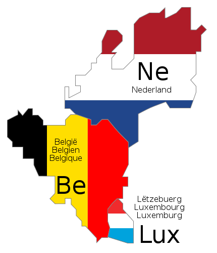
| Description |
Deutsch: Schematische Karte der Benelux-Länder. Die Länderbezeichnungen sind jeweils in den offiziellen Landessprachen angegeben.
English: Schematic map of Benelux. The country names are given in the official languages of each state.
Français : Carte schématique du Benelux. Les noms des pays sont indiqués dans les langues officielles respectives de chaque état.
Nederlands: Schematische kaart van de Benelux. De landsnamen worden weergegeven in de officiële taal of talen van het betreffende land. |
||||||||
| Date | |||||||||
| Source | Own work. The schematic design is derived from Benelux.png (released under GFDL), and the flag colors were taken from Flag of Belgium.svg, Flag of Luxembourg.svg and Flag of the Netherlands.svg (both PD) | ||||||||
| Author |
|
||||||||
| Permission (Reusing this file) |
|
||||||||
| Other versions |
|
||||||||
| SVG development |


File history
Click on a date/time to view the file as it appeared at that time.
| Date/Time | Thumbnail | Dimensions | User | Comment | |
|---|---|---|---|---|---|
| current | 10:46, 17 June 2009 | | 430 × 500 (20 KB) | Bibi Saint-Pol (talk | contribs) | fix internal trouble with text nodes |
| 10:28, 17 June 2009 |  | 430 × 500 (21 KB) | Bibi Saint-Pol (talk | contribs) | {{inkscape}} {{Information |Description= {{en|1=Schematic map of w:en:Benelux. The country names are given in the official languages of each state.}} {{fr|1=Carte schématique du w:fr:Benelux. Les noms des pays sont indiqués dans les langues of |
You cannot overwrite this file.
File usage on Commons
The following 3 pages use this file:
File usage on other wikis
The following other wikis use this file:
- Usage on de.wikipedia.org
- Usage on ko.wikipedia.org
- Usage on ru.wikipedia.org
- Usage on uz.wikipedia.org
- Usage on zh.wikipedia.org