File:Beijing-Subway-Plan en.svg
Jump to navigation
Jump to search

Size of this PNG preview of this SVG file: 756 × 600 pixels. Other resolutions: 303 × 240 pixels | 605 × 480 pixels | 968 × 768 pixels | 1,280 × 1,015 pixels | 2,560 × 2,030 pixels | 2,900 × 2,300 pixels.
Original file (SVG file, nominally 2,900 × 2,300 pixels, file size: 188 KB)
Captions
Captions
Add a one-line explanation of what this file represents
Summary[edit]
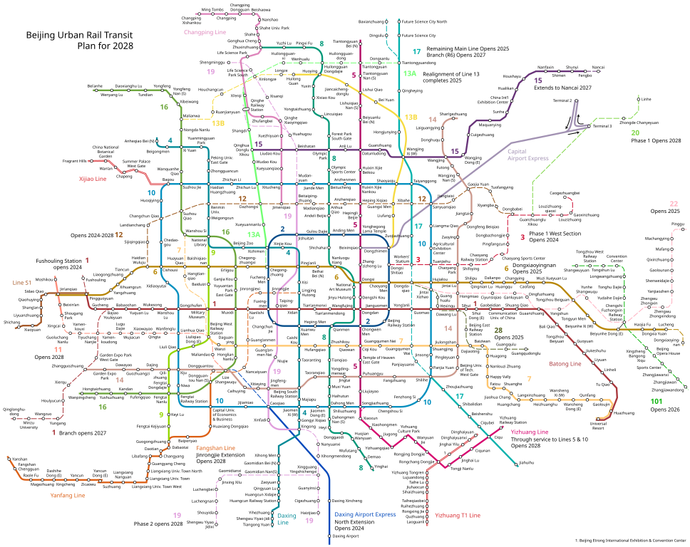
| Description |
English: English version of Image:Beijing-Subway-Plan.svg |
| Date | |
| Source | Own work |
| Author | Ran and Hat600 |
This W3C-unspecified vector image was created with Adobe Illustrator.
Licensing[edit]
I, the copyright holder of this work, hereby publish it under the following licenses:
This file is licensed under the Creative Commons Attribution-Share Alike 3.0 Unported license.
- You are free:
- to share – to copy, distribute and transmit the work
- to remix – to adapt the work
- Under the following conditions:
- attribution – You must give appropriate credit, provide a link to the license, and indicate if changes were made. You may do so in any reasonable manner, but not in any way that suggests the licensor endorses you or your use.
- share alike – If you remix, transform, or build upon the material, you must distribute your contributions under the same or compatible license as the original.

|
Permission is granted to copy, distribute and/or modify this document under the terms of the GNU Free Documentation License, Version 1.2 or any later version published by the Free Software Foundation; with no Invariant Sections, no Front-Cover Texts, and no Back-Cover Texts. A copy of the license is included in the section entitled GNU Free Documentation License. |
You may select the license of your choice.
| Annotations | This image is annotated: View the annotations at Commons |
File history
Click on a date/time to view the file as it appeared at that time.
| Date/Time | Thumbnail | Dimensions | User | Comment | |
|---|---|---|---|---|---|
| current | 17:36, 29 December 2023 | | 2,900 × 2,300 (188 KB) | Hat600 (talk | contribs) | update |
| 08:48, 1 October 2023 |  | 2,900 × 2,300 (188 KB) | Hat600 (talk | contribs) | update; see release note at File talk:Beijing-Subway-Plan.png | |
| 03:33, 4 February 2023 |  | 2,900 × 2,200 (161 KB) | Hat600 (talk | contribs) | update | |
| 00:17, 31 December 2022 |  | 2,900 × 2,200 (161 KB) | Hat600 (talk | contribs) | update | |
| 07:49, 9 February 2022 |  | 2,900 × 2,200 (157 KB) | Hat600 (talk | contribs) | update and station name changes | |
| 20:09, 30 December 2021 |  | 2,900 × 2,200 (161 KB) | Hat600 (talk | contribs) | update; i dont have enough time to correct the new translation, it will be done in a few days | |
| 06:56, 25 July 2021 |  | 2,900 × 2,200 (163 KB) | Hat600 (talk | contribs) | update | |
| 08:23, 16 February 2021 |  | 2,900 × 2,200 (163 KB) | Hat600 (talk | contribs) | fix for en translation of Line S1 | |
| 15:46, 30 December 2020 |  | 2,900 × 2,200 (163 KB) | Hat600 (talk | contribs) | update; ALL en translations of unopened stations are subject to change; opening scedule is expected to be updated in a few weeks; yizhuang tram included as the official beijing subway map does so | |
| 16:15, 27 December 2019 |  | 2,900 × 2,200 (154 KB) | Hat600 (talk | contribs) | update |
You cannot overwrite this file.
File usage on Commons
The following 71 pages use this file:
- User:Chumwa/OgreBot/Potential transport maps/2016 December 21-31
- User:Chumwa/OgreBot/Potential transport maps/2016 January 21-31
- User:Chumwa/OgreBot/Potential transport maps/2017 August 11-20
- User:Chumwa/OgreBot/Potential transport maps/2017 December 21-31
- User:Chumwa/OgreBot/Potential transport maps/2017 January 11-20
- User:Chumwa/OgreBot/Potential transport maps/2018 December 21-31
- User:Chumwa/OgreBot/Potential transport maps/2019 August 11-20
- User:Chumwa/OgreBot/Potential transport maps/2019 December 21-31
- User:Chumwa/OgreBot/Potential transport maps/2019 January 1-10
- User:Chumwa/OgreBot/Potential transport maps/2019 November 11-20
- User:Chumwa/OgreBot/Potential transport maps/2019 September 21-30
- User:Chumwa/OgreBot/Public transport information/2015 December 21-31
- User:Chumwa/OgreBot/Public transport information/2015 February 1-9
- User:Chumwa/OgreBot/Public transport information/2015 October 1-10
- User:Chumwa/OgreBot/Public transport information/2015 October 11-20
- User:Chumwa/OgreBot/Public transport information/2015 October 21-31
- User:Chumwa/OgreBot/Public transport information/2016 December 21-31
- User:Chumwa/OgreBot/Public transport information/2016 January 21-31
- User:Chumwa/OgreBot/Public transport information/2017 August 11-20
- User:Chumwa/OgreBot/Public transport information/2017 December 21-31
- User:Chumwa/OgreBot/Public transport information/2017 January 11-20
- User:Chumwa/OgreBot/Public transport information/2018 December 21-31
- User:Chumwa/OgreBot/Public transport information/2019 August 11-20
- User:Chumwa/OgreBot/Public transport information/2019 December 21-31
- User:Chumwa/OgreBot/Public transport information/2019 January 1-10
- User:Chumwa/OgreBot/Public transport information/2019 November 11-20
- User:Chumwa/OgreBot/Public transport information/2019 September 21-30
- User:Chumwa/OgreBot/Public transport information/2020 December 21-31
- User:Chumwa/OgreBot/Public transport information/2021 December 21-31
- User:Chumwa/OgreBot/Public transport information/2021 February 10-18
- User:Chumwa/OgreBot/Public transport information/2021 July 21-31
- User:Chumwa/OgreBot/Public transport information/2022 December 21-31
- User:Chumwa/OgreBot/Public transport information/2022 February 1-9
- User:Chumwa/OgreBot/Public transport information/2023 December 21-31
- User:Chumwa/OgreBot/Public transport information/2023 February 1-9
- User:Chumwa/OgreBot/Public transport information/2023 October 1-10
- User:Chumwa/OgreBot/Transport Maps/2015 December 21-31
- User:Chumwa/OgreBot/Transport Maps/2015 February 1-9
- User:Chumwa/OgreBot/Transport Maps/2015 October 1-10
- User:Chumwa/OgreBot/Transport Maps/2015 October 11-20
- User:Chumwa/OgreBot/Transport Maps/2015 October 21-31
- User:Chumwa/OgreBot/Transport Maps/2016 December 21-31
- User:Chumwa/OgreBot/Transport Maps/2016 January 21-31
- User:Chumwa/OgreBot/Transport Maps/2017 August 11-20
- User:Chumwa/OgreBot/Transport Maps/2017 December 21-31
- User:Chumwa/OgreBot/Transport Maps/2017 January 11-20
- User:Chumwa/OgreBot/Transport Maps/2018 December 21-31
- User:Chumwa/OgreBot/Transport Maps/2019 August 11-20
- User:Chumwa/OgreBot/Transport Maps/2019 December 21-31
- User:Chumwa/OgreBot/Transport Maps/2019 January 1-10
- User:Chumwa/OgreBot/Transport Maps/2019 November 11-20
- User:Chumwa/OgreBot/Transport Maps/2019 September 21-30
- User:Chumwa/OgreBot/Transport Maps/2020 December 21-31
- User:Chumwa/OgreBot/Transport Maps/2021 December 21-31
- User:Chumwa/OgreBot/Transport Maps/2021 February 10-18
- User:Chumwa/OgreBot/Transport Maps/2021 July 21-31
- User:Chumwa/OgreBot/Transport Maps/2022 December 21-31
- User:Chumwa/OgreBot/Transport Maps/2022 February 1-9
- User:Chumwa/OgreBot/Transport Maps/2023 December 21-31
- User:Chumwa/OgreBot/Transport Maps/2023 February 1-9
- User:Chumwa/OgreBot/Transport Maps/2023 October 1-10
- User:Chumwa/OgreBot/Travel and communication maps/2016 December 21-31
- User:Chumwa/OgreBot/Travel and communication maps/2016 January 21-31
- User:Chumwa/OgreBot/Travel and communication maps/2017 August 11-20
- User:Chumwa/OgreBot/Travel and communication maps/2017 December 21-31
- User:Chumwa/OgreBot/Travel and communication maps/2017 January 11-20
- User:Chumwa/OgreBot/Travel and communication maps/2018 December 21-31
- User:Chumwa/OgreBot/Travel and communication maps/2019 August 11-20
- User:Chumwa/OgreBot/Travel and communication maps/2019 January 1-10
- User:Chumwa/OgreBot/Travel and communication maps/2019 September 21-30
- User:Liesel/Rail transport/2015 February 1-9
File usage on other wikis
The following other wikis use this file:
- Usage on de.wikipedia.org