File:Battle of Saipan Map.svg
Jump to navigation
Jump to search

Size of this PNG preview of this SVG file: 551 × 599 pixels. Other resolutions: 221 × 240 pixels | 441 × 480 pixels | 706 × 768 pixels | 941 × 1,024 pixels | 1,883 × 2,048 pixels | 1,800 × 1,958 pixels.
Original file (SVG file, nominally 1,800 × 1,958 pixels, file size: 4.66 MB)
Captions
Captions
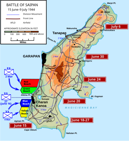
Map of the Battle of Saipan
Summary[edit]
| Description |
English: Map of the Battle of Saipan, June 15-July 9, 1944. . Geological features based on Battle of Saipan Map.jpg. Front lines, division movements and additional roads derived from maps in Hoffman, Carl W. (1950) Saipan: The Beginning of the End, Historical Branch, United States Marine Corps OCLC: 564000243. USMA Military Atlas served as inspiration for some of the design elements.
White to dark orange elevations chosen from 5 scale color scheme by Color Brewer to maximize contrast for color blindness. Images tested for achromatic color blindness using Toptal Color Filter. Green to dark orange elevations chosen for compatibility with other maps of the Marianas invasions: Battle of Tinian and Battle of Guam |
| Date | |
| Source |
Own work This W3C-unspecified vector image was created with Inkscape . |
| Author | Wtfiv |
.svg)
Licensing[edit]
I, the copyright holder of this work, hereby publish it under the following license:
This file is licensed under the Creative Commons Attribution 4.0 International license.
- You are free:
- to share – to copy, distribute and transmit the work
- to remix – to adapt the work
- Under the following conditions:
- attribution – You must give appropriate credit, provide a link to the license, and indicate if changes were made. You may do so in any reasonable manner, but not in any way that suggests the licensor endorses you or your use.
File history
Click on a date/time to view the file as it appeared at that time.
| Date/Time | Thumbnail | Dimensions | User | Comment | |
|---|---|---|---|---|---|
| current | 04:53, 18 April 2024 | | 1,800 × 1,958 (4.66 MB) | Wtfiv (talk | contribs) | update legend |
| 04:00, 18 April 2024 |  | 1,800 × 1,958 (4.66 MB) | Wtfiv (talk | contribs) | minor color fixes | |
| 03:39, 18 April 2024 |  | 1,800 × 1,958 (4.66 MB) | Wtfiv (talk | contribs) | oops, uploaded wrong map! | |
| 03:34, 18 April 2024 |  | 1,798 × 1,955 (4.69 MB) | Wtfiv (talk | contribs) | Colors match tinian and guam maps | |
| 02:52, 17 April 2024 |  | 1,800 × 1,958 (4.66 MB) | Wtfiv (talk | contribs) | modified location of unit identifiers | |
| 23:44, 16 April 2024 |  | 1,800 × 1,958 (4.66 MB) | Wtfiv (talk | contribs) | en-dash in legend | |
| 05:56, 4 March 2024 |  | 1,800 × 1,958 (4.66 MB) | Wtfiv (talk | contribs) | Title change | |
| 18:28, 3 March 2024 |  | 1,800 × 1,958 (4.66 MB) | Wtfiv (talk | contribs) | slightly changing divisional advance path coloring for greater discrimination | |
| 18:12, 3 March 2024 |  | 1,800 × 1,958 (4.66 MB) | Wtfiv (talk | contribs) | more slight changes to beach graphics | |
| 17:43, 1 March 2024 |  | 1,800 × 1,958 (4.66 MB) | Wtfiv (talk | contribs) | Adjusted beaches, added Aftetna point |
You cannot overwrite this file.
File usage on Commons
The following 6 pages use this file:
File usage on other wikis
The following other wikis use this file:
- Usage on en.wikipedia.org