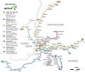
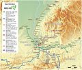
File:Basel - Regio-S-Bahn Basel - Netzplan.jpg

Original file (2,470 × 2,094 pixels, file size: 1.39 MB, MIME type: image/jpeg)
Captions
Captions
Summary[edit]
| DescriptionBasel - Regio-S-Bahn Basel - Netzplan.jpg |
|
|
| Date | ||
| Source |
Own work The Regio S-Bahn logo was reworked by myself. |
|
| Author | Maximilian Dörrbecker (Chumwa) | |
| Permission (Reusing this file) |
I, the copyright holder of this work, hereby publish it under the following license: This file is licensed under the Creative Commons Attribution-Share Alike 2.5 Generic license.
Sie dürfen das Bild zu den folgenden Bedingungen nutzen:
|
|
| Other versions |
|

|
This transport map image could be re-created using vector graphics as an SVG file. This has several advantages; see Commons:Media for cleanup for more information. If an SVG form of this image is available, please upload it and afterwards replace this template with
{{vector version available|new image name}}.
It is recommended to name the SVG file “Basel - Regio-S-Bahn Basel - Netzplan.svg”—then the template Vector version available (or Vva) does not need the new image name parameter. |
 | This transport map image was uploaded in the JPEG format even though it consists of non-photographic data. This information could be stored more efficiently or accurately in the PNG or SVG format. If possible, please upload a PNG or SVG version of this image without compression artifacts, derived from a non-JPEG source (or with existing artifacts removed). After doing so, please tag the JPEG version with {{Superseded|NewImage.ext}} and remove this tag. This tag should not be applied to photographs or scans. If this image is a diagram or other image suitable for vectorisation, please tag this image with {{Convert to SVG}} instead of {{BadJPEG}}. If not suitable for vectorisation, use {{Convert to PNG}}. For more information, see {{BadJPEG}}. |
File history
Click on a date/time to view the file as it appeared at that time.
| Date/Time | Thumbnail | Dimensions | User | Comment | |
|---|---|---|---|---|---|
| current | 06:04, 5 August 2016 |  | 2,470 × 2,094 (1.39 MB) | Chumwa (talk | contribs) | Verbindung Müllheim - Mulhouse, Verlängerung Verstärkerzüge S5 |
| 08:03, 2 January 2010 |  | 2,470 × 2,094 (903 KB) | Chumwa (talk | contribs) | nochmaliger Upload, nachdem beim letzten Upload offensichtlich etwas schiefgegangen ist... | |
| 07:52, 2 January 2010 |  | 2,470 × 2,094 (1.12 MB) | Chumwa (talk | contribs) | Typo: Besse → Messe | |
| 07:01, 25 December 2009 |  | 2,471 × 2,094 (495 KB) | Chumwa (talk | contribs) | update | |
| 05:42, 30 May 2009 |  | 2,471 × 2,094 (493 KB) | Chumwa (talk | contribs) | Waldenburgerbahn hinzugefügt und Haltestellen Pratteln Salina Raurica und Rheinfelden Augarten ergänzt (Danke an Dimelina für die Hinweise!]]. | |
| 23:16, 26 March 2008 |  | 2,471 × 2,094 (754 KB) | Chumwa (talk | contribs) | Nochmal drei Korrekturanmerkungen von de:User:Samoehrle eingearbeitet (danke hierfür!). | |
| 21:13, 25 March 2008 |  | 2,471 × 2,094 (1.11 MB) | Chumwa (talk | contribs) | Fehlerhinweise von Mistaby und Samoehrle eingearbeitet (Einmeldingen -> Eimeldingen, Elken -> Eiken, S5 nur als Spitzenverstärker bis Schopfheim). | |
| 06:14, 14 March 2008 |  | 2,471 × 2,094 (1.11 MB) | Chumwa (talk | contribs) | Linienende der S5 korrigiert (Danke an Stephan für den Fehlerhinweis!) | |
| 19:15, 11 March 2008 |  | 2,471 × 2,094 (1.11 MB) | Chumwa (talk | contribs) | Basel-Layer entfernt und Grenzlinien kontrastierender dargestellt. | |
| 01:29, 9 March 2008 |  | 4,941 × 4,187 (980 KB) | Chumwa (talk | contribs) | {{Information |Description= *{{ de }} Karte: Netzplan der Regio S-Bahn Basel *{{ en }} Map: Basel Regio S-Bahn network *{{ fr }} Plan: Réseau du Regio S-Bahn de Bâle |Source=Self made The Regio S-Bahn logo was reworked by myself. |Date=March 2008 |Auth |
You cannot overwrite this file.
File usage on Commons
The following 8 pages use this file:
- User:Chumwa/Gallery
- User:Chumwa/OgreBot/Potential transport maps/2016 August 1-10
- User:Chumwa/OgreBot/Public transport information/2016 August 1-10
- User:Chumwa/OgreBot/Transport Maps/2016 August 1-10
- User:Chumwa/OgreBot/Travel and communication maps/2016 August 1-10
- User:Flominator/FR/2016 August 1-10
- File:Basel - Regio-S-Bahn Basel - Netzplan.jpg
- File:Basel - Regio-S-Bahn Basel - Netzplan (mit Hintergrund).jpg
File usage on other wikis
The following other wikis use this file:
- Usage on de.wikipedia.org
Metadata
This file contains additional information such as Exif metadata which may have been added by the digital camera, scanner, or software program used to create or digitize it. If the file has been modified from its original state, some details such as the timestamp may not fully reflect those of the original file. The timestamp is only as accurate as the clock in the camera, and it may be completely wrong.
| Orientation | Normal |
|---|---|
| Horizontal resolution | 99.9998 dpi |
| Vertical resolution | 99.9998 dpi |
| Software used | Adobe Photoshop CS5.1 Windows |
| File change date and time | 08:03, 5 August 2016 |
| Color space | sRGB |
| Date and time of digitizing | 10:01, 5 August 2016 |
| Date metadata was last modified | 10:03, 5 August 2016 |
| Unique ID of original document | xmp.did:CE38C7D7D15AE6118C54BD8F5110CE6A |


