File:Austria-Hungary map mk.svg
Jump to navigation
Jump to search

Size of this PNG preview of this SVG file: 776 × 600 pixels. Other resolutions: 311 × 240 pixels | 621 × 480 pixels | 994 × 768 pixels | 1,280 × 989 pixels | 2,560 × 1,978 pixels | 783 × 605 pixels.
Original file (SVG file, nominally 783 × 605 pixels, file size: 412 KB)
Captions
Captions
Add a one-line explanation of what this file represents
Summary[edit]
| Description |
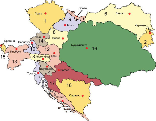
Македонски: Австроунгарија во 1910 г.
Австрија
English: Map of the Austro-Hungarian Empire in 1910, labels in Macedonian. |
| Date | |
| Source | File:Austria-Hungary map.svg |
| Author |
original by :IMeowbot derivative by B. Jankuloski |
| Other versions |
[]
|


Licensing[edit]
| This file is made available under the Creative Commons CC0 1.0 Universal Public Domain Dedication. | |
| The person who associated a work with this deed has dedicated the work to the public domain by waiving all of their rights to the work worldwide under copyright law, including all related and neighboring rights, to the extent allowed by law. You can copy, modify, distribute and perform the work, even for commercial purposes, all without asking permission.
|
File history
Click on a date/time to view the file as it appeared at that time.
| Date/Time | Thumbnail | Dimensions | User | Comment | |
|---|---|---|---|---|---|
| current | 12:18, 20 August 2023 | | 783 × 605 (412 KB) | Bjankuloski06 (talk | contribs) | Uploaded a work by original by :IMeowbot<br>derivative by B. Jankuloski from File:Austria-Hungary map.svg with UploadWizard |
You cannot overwrite this file.
File usage on Commons
The following page uses this file: