File:Atlas Van der Hagen-KW1049B10 091-DANVBIVS, FLUVIUS EUROPAE MAXIMUS, A FONTIBVS AD OSTIA, Cum omnibus Flumnibus ab utroque latere, in ullum defluentibus..jpeg
Jump to navigation
Jump to search

Size of this preview: 800 × 356 pixels. Other resolutions: 320 × 142 pixels | 640 × 285 pixels | 1,024 × 456 pixels | 1,280 × 570 pixels | 2,560 × 1,139 pixels | 5,500 × 2,448 pixels.
Original file (5,500 × 2,448 pixels, file size: 2.33 MB, MIME type: image/jpeg)
Captions
Captions
Add a one-line explanation of what this file represents
Summary[edit]
| Dirk Jansz van Santen: Atlas van Dirk van der Hagen (volledig, collectie KB)
|
|||||||||||||||||||||||||||||
|---|---|---|---|---|---|---|---|---|---|---|---|---|---|---|---|---|---|---|---|---|---|---|---|---|---|---|---|---|---|
| Artist |
|
 | |||||||||||||||||||||||||||
| Author |
Publisher:
|
||||||||||||||||||||||||||||
| Title |
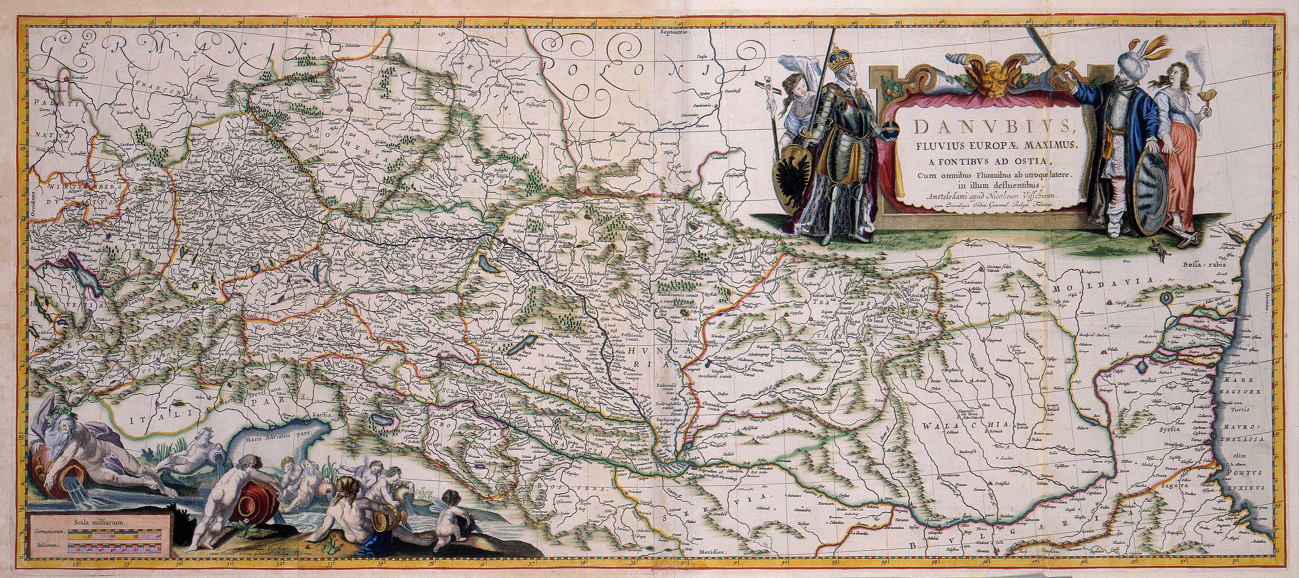
DANVBIVS, FLUVIUS EUROPAE MAXIMUS, A FONTIBVS AD OSTIA, Cum omnibus Flumnibus ab utroque latere, in ullum defluentibus. |
||||||||||||||||||||||||||||
| Object type | map | ||||||||||||||||||||||||||||
| Description |
Nederlands: Deze kaart, een uitgave door Nicolaes Visscher II (1649-1702), werd oorspronkelijk al in 1635 uitgegeven door Willem Jansz. Blaeu (1571-1638). Ondanks dat sedertdien al bijna 50 jaar waren verstreken, had de kaart aan actualiteit niets verloren. De grote titelcartouche symboliseert de tegenstellingen tussen de twee grote godsdiensten die door de rivier van elkaar werden gescheiden: de Oostenrijkse keizer die het Christendom verdedigt en een Turkse vizier die de Islam beschermt.
English: This map, a publication by Nicolaes Visscher II (1649-1702), was originally published in 1635 by Willem Jansz. Blaeu (1571-1638). Although almost 50 years later, the map had lost little of its actuality. |
||||||||||||||||||||||||||||
| Language |
Dutch |
||||||||||||||||||||||||||||
| Date | after 1681 | ||||||||||||||||||||||||||||
| Publication date |
circa |
||||||||||||||||||||||||||||
| Medium |
Nederlands: kopergravure
English: copper engraving print |
||||||||||||||||||||||||||||
| Dimensions | 41 x 92 cm | ||||||||||||||||||||||||||||
| Collection |
|
||||||||||||||||||||||||||||
| Accession number |
Description of the Atlas Van der Hagen in the catalogue of the KB: http://opc4.kb.nl/DB=1/TTL=1/LNG=EN/PPN?PPN=353012750 |
||||||||||||||||||||||||||||
| Place of creation |
Netherlands |
||||||||||||||||||||||||||||
| Notes | KW1049B10_091 - Volume 1 | ||||||||||||||||||||||||||||
| Related persons | Nicolaes Visscher II - Willem Jansz. Blaeu | ||||||||||||||||||||||||||||
| Depicted locations | Danube - Germany - Austria - Turkey | ||||||||||||||||||||||||||||
| References | |||||||||||||||||||||||||||||
| Source/Photographer |
Source page at the Geheugen van Nederland / Memory of the Netherlands website.
|
||||||||||||||||||||||||||||
| Permission (Reusing this file) |
|
||||||||||||||||||||||||||||

File history
Click on a date/time to view the file as it appeared at that time.
| Date/Time | Thumbnail | Dimensions | User | Comment | |
|---|---|---|---|---|---|
| current | 22:12, 18 July 2015 | | 5,500 × 2,448 (2.33 MB) | OlafJanssen (talk | contribs) | GWToolset: Creating mediafile for OlafJanssen. |
You cannot overwrite this file.
File usage on Commons
The following 4 pages use this file:
File usage on other wikis
The following other wikis use this file:
- Usage on hu.wikipedia.org