File:Apetlon tiefster messpunkt oesterreichs 01.JPG
Jump to navigation
Jump to search
Size of this preview: 800 × 600 pixels. Other resolutions: 320 × 240 pixels | 640 × 480 pixels | 1,024 × 768 pixels | 1,280 × 960 pixels | 2,560 × 1,920 pixels | 3,648 × 2,736 pixels.
Original file (3,648 × 2,736 pixels, file size: 1.94 MB, MIME type: image/jpeg)
Captions
Captions
Add a one-line explanation of what this file represents
Summary[edit]
| Description |
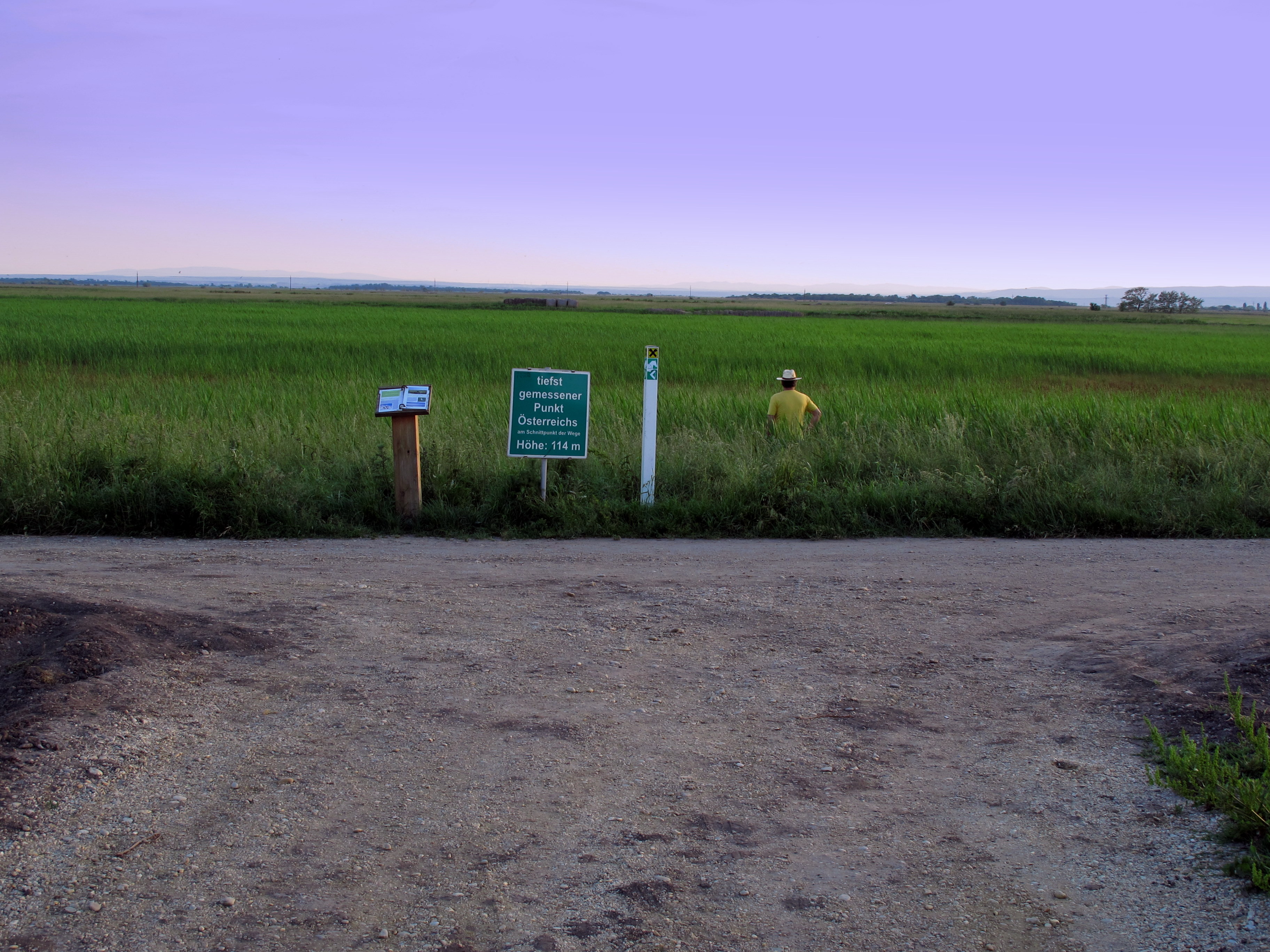
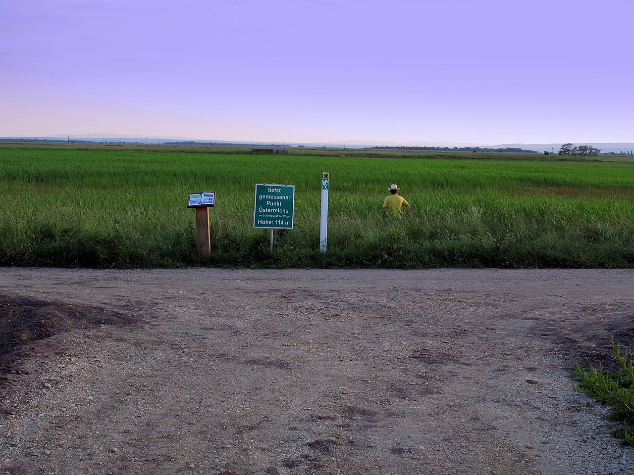
Deutsch: Schild: „tiefst gemessener Punkt Österreichs am Schnittpunkt der Wege. Höhe: 114 m.“ in der Gemeinde Apetlon am Ostufer des Neusiedlersees im Burgenland / Österreich / Europäische Union. Neben dem Schild befindet sich eine Informationssäule mit Hinweisen zu Fauna und Flora der Umgebung. Blickrichtung Südwesten. Wie an der Person (Mann mit gelbem T-Shirt und Hut) im Bild erkennbar, fällt das Gelände in der Sumpfwiese neben dem Messpunkt noch ein wenig tiefer ab. Bei einen Besuch ab Mitte Mai ist ein Schutz gegen Stechmücken empfehlenswert.
English: Signpost for the lowest measuring point in Austria in the community Apetlon at Lake Neusiedl near Vienna / Austria / European Union. Beside the sign is an information column with notes on the flora and fauna of the environment. View towards the southwest. As can be seen on the person in the picture, the area falls in the swamp next to the measuring point from a little deeper. With a visit from mid-May, a protection against mosquitoes is recommended. |
|
| Date | ||
| Source | Own work | |
| Author | Joadl | |
| Permission (Reusing this file) |
|
| Camera location | | View this and other nearby images on: OpenStreetMap |
|---|
Licensing[edit]
I, the copyright holder of this work, hereby publish it under the following licenses:

|
Permission is granted to copy, distribute and/or modify this document under the terms of the GNU Free Documentation License, Version 1.2 or any later version published by the Free Software Foundation; with no Invariant Sections, no Front-Cover Texts, and no Back-Cover Texts. A copy of the license is included in the section entitled GNU Free Documentation License. |
This file is licensed under the Creative Commons Attribution-Share Alike 3.0 Unported, 2.5 Generic, 2.0 Generic and 1.0 Generic license.
- You are free:
- to share – to copy, distribute and transmit the work
- to remix – to adapt the work
- Under the following conditions:
- attribution – You must give appropriate credit, provide a link to the license, and indicate if changes were made. You may do so in any reasonable manner, but not in any way that suggests the licensor endorses you or your use.
- share alike – If you remix, transform, or build upon the material, you must distribute your contributions under the same or compatible license as the original.
You may select the license of your choice.
File history
Click on a date/time to view the file as it appeared at that time.
| Date/Time | Thumbnail | Dimensions | User | Comment | |
|---|---|---|---|---|---|
| current | 07:24, 23 February 2019 | | 3,648 × 2,736 (1.94 MB) | Karl Gruber (talk | contribs) | Reverted to version as of 19:46, 25 May 2010 (UTC) Der Trigpunkt ist mitten auf der Straße und sollte deswegen nicht weggeschnitten werden |
| 14:52, 5 October 2017 |  | 3,648 × 2,736 (1.82 MB) | Martin Geisler (talk | contribs) | cropped, heller | |
| 19:46, 25 May 2010 |  | 3,648 × 2,736 (1.94 MB) | Joadl (talk | contribs) | == {{int:filedesc}} == {{Information |Description= {{de|Beschreibung folgt}} {{en|comming soon}} |Source={{own}} |Date=2009-05-07 |Author=Joadl |Permission={{User:Joadl/Ref}} |other_versions= }} {{location|47|44|5.71|N|16|51|47.92|E|region: |
You cannot overwrite this file.
File usage on Commons
The following page uses this file:
File usage on other wikis
The following other wikis use this file:
- Usage on de.wikipedia.org
- Usage on nn.wikipedia.org