File:Ansfelden Kremsbrücke Schellingstrasse-0734.jpg
Original file (5,470 × 3,647 pixels, file size: 18.83 MB, MIME type: image/jpeg)
Captions
Summary[edit]
DescriptionAnsfelden Kremsbrücke Schellingstrasse-0734.jpg |
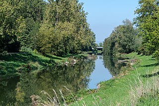
Deutsch: Die Krems auf dem Gemeindegebiet von Ansfelden oberhalb der Wehr von Ritzelhof und der Brücke Schellingstraße
English: River Krems is a tributary of the river Traun in Upper Austria.
|
Date | |
Source | Own work |
Author | Isiwal |
Camera location | 48° 10′ 40.92″ N, 14° 14′ 51.57″ E | View this and other nearby images on: OpenStreetMap | 48.178032; 14.247658 |
---|
Licensing[edit]
- You are free:
- to share – to copy, distribute and transmit the work
- to remix – to adapt the work
- Under the following conditions:
- attribution – You must give appropriate credit, provide a link to the license, and indicate if changes were made. You may do so in any reasonable manner, but not in any way that suggests the licensor endorses you or your use.
- share alike – If you remix, transform, or build upon the material, you must distribute your contributions under the same or compatible license as the original.
Diese Datei wurde im Rahmen von WikiDaheim 2018 in Österreich erstellt und hochgeladen. Sie wurde dem allgemeinen Themenbereich zugeordnet. |
This image has been assessed using the Quality image guidelines and is considered a Quality image.
العربية ∙ جازايرية ∙ беларуская ∙ беларуская (тарашкевіца) ∙ български ∙ বাংলা ∙ català ∙ čeština ∙ Cymraeg ∙ Deutsch ∙ Schweizer Hochdeutsch ∙ Zazaki ∙ Ελληνικά ∙ English ∙ Esperanto ∙ español ∙ eesti ∙ euskara ∙ فارسی ∙ suomi ∙ français ∙ galego ∙ עברית ∙ हिन्दी ∙ hrvatski ∙ magyar ∙ հայերեն ∙ Bahasa Indonesia ∙ italiano ∙ 日本語 ∙ Jawa ∙ ქართული ∙ 한국어 ∙ kurdî ∙ Lëtzebuergesch ∙ lietuvių ∙ македонски ∙ മലയാളം ∙ मराठी ∙ Bahasa Melayu ∙ Nederlands ∙ Norfuk / Pitkern ∙ polski ∙ português ∙ português do Brasil ∙ rumantsch ∙ română ∙ русский ∙ sicilianu ∙ slovenčina ∙ slovenščina ∙ shqip ∙ српски / srpski ∙ svenska ∙ தமிழ் ∙ తెలుగు ∙ ไทย ∙ Tagalog ∙ Türkçe ∙ toki pona ∙ українська ∙ vèneto ∙ Tiếng Việt ∙ 中文 ∙ 中文(简体) ∙ 中文(繁體) ∙ +/− |
Annotations InfoField | This image is annotated: View the annotations at Commons |
File history
Click on a date/time to view the file as it appeared at that time.
Date/Time | Thumbnail | Dimensions | User | Comment | |
---|---|---|---|---|---|
current | 17:55, 18 September 2018 | 5,470 × 3,647 (18.83 MB) | Isiwal (talk | contribs) | User created page with UploadWizard |
You cannot overwrite this file.
File usage on Commons
The following 4 pages use this file:
File usage on other wikis
The following other wikis use this file:
- Usage on arz.wikipedia.org
- Usage on de.wikipedia.org
- Usage on en.wikipedia.org
- Usage on hu.wikipedia.org
- Usage on it.wikipedia.org
- Usage on la.wikipedia.org
- Usage on ro.wikipedia.org
- Usage on war.wikipedia.org
- Usage on www.wikidata.org
Metadata
This file contains additional information such as Exif metadata which may have been added by the digital camera, scanner, or software program used to create or digitize it. If the file has been modified from its original state, some details such as the timestamp may not fully reflect those of the original file. The timestamp is only as accurate as the clock in the camera, and it may be completely wrong.
Camera manufacturer | NIKON CORPORATION |
---|---|
Camera model | NIKON D500 |
Exposure time | 1/200 sec (0.005) |
F-number | f/8 |
ISO speed rating | 100 |
Date and time of data generation | 14:09, 18 September 2018 |
Lens focal length | 65 mm |
Latitude | 48° 10′ 40.91″ N |
Longitude | 14° 14′ 51.57″ E |
Altitude | 280 meters above sea level |
Horizontal resolution | 300 dpi |
Vertical resolution | 300 dpi |
Software used | Adobe Photoshop Lightroom Classic 7.5 (Windows) |
File change date and time | 16:33, 18 September 2018 |
Exposure Program | Aperture priority |
Exif version | 2.3 |
Date and time of digitizing | 14:09, 18 September 2018 |
APEX shutter speed | 7.643856 |
APEX aperture | 6 |
APEX exposure bias | 0 |
Maximum land aperture | 3 APEX (f/2.83) |
Metering mode | Pattern |
Light source | Unknown |
Flash | Flash did not fire |
DateTimeOriginal subseconds | 77 |
DateTimeDigitized subseconds | 77 |
Color space | sRGB |
Focal plane X resolution | 2,360.8599243164 |
Focal plane Y resolution | 2,360.8599243164 |
Focal plane resolution unit | 3 |
Sensing method | One-chip color area sensor |
File source | Digital still camera |
Scene type | A directly photographed image |
Custom image processing | Normal process |
Exposure mode | Auto exposure |
White balance | Auto white balance |
Focal length in 35 mm film | 97 mm |
Scene capture type | Standard |
Scene control | None |
Contrast | Normal |
Saturation | Normal |
Sharpness | Normal |
Subject distance range | Unknown |
GPS tag version | 0.0.2.2 |
Serial number of camera | 6032098 |
Lens used | TAMRON SP 24-70mm F/2.8 Di VC USD G2 A032N |
Date metadata was last modified | 18:33, 18 September 2018 |
Unique ID of original document | 1552A04904FFACD889F0580915AD5D61 |
IIM version | 4 |
Structured data
Items portrayed in this file
depicts
18 September 2018
48°10'40.915"N, 14°14'51.569"E
image/jpeg
4e61fd272b93ae35bd3b4e69645d51920ebc58fc
19,742,992 byte
3,647 pixel
5,470 pixel
- Nature reserves in Austria with known ID
- Files with coordinates missing SDC location of creation
- CC-BY-SA-4.0
- Self-published work
- Media from WikiDaheim 2018 in Austria/all
- Media from WikiDaheim 2018 in Austria/Unspecified
- Media from WikiDaheim in Austria check done
- Uploaded via Campaign:WikiDaheim-at
- Quality images from WikiDaheim
- Quality images by Isiwal
- Quality images
- Quality images missing SDC depicts
- Austria photographs taken on 2018-09-18
- Quality images of Austria
- Images with annotations
- Pages with maps