File:Anger - Feistritztalbahn, Hart-Tunnel.JPG
Jump to navigation
Jump to search

Size of this preview: 800 × 490 pixels. Other resolutions: 320 × 196 pixels | 640 × 392 pixels | 1,024 × 627 pixels | 1,280 × 784 pixels | 2,560 × 1,568 pixels | 4,800 × 2,940 pixels.
Original file (4,800 × 2,940 pixels, file size: 9.07 MB, MIME type: image/jpeg)
Captions
Captions
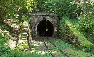
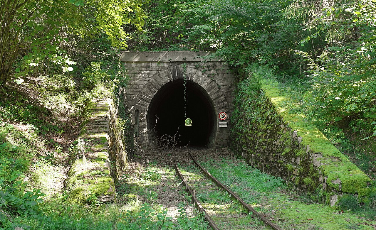
West portal of the Harttunnel of the Feistritztalbahn in Austria.
Summary[edit]
| Description |
Deutsch: Westportal des Hart-Tunnels der Feistritztalbahn in Hart, einem Ortsteil der steirischen Marktgemeinde Anger.
Der 223 m lange Hart-Tunnel ist einer von drei Tunneln der rd. 24 km langen Feistritztalbahn, einer Schmalspurbahn zwischen Weiz und Birkfeld. Eröffnet wurde die Bahn am 14/15. Dezember 1911 und 1973 wurde der öffentliche Personenverkehr zur Gänze eingestellt. Mit Bescheid vom 2. Feb. 2011 wurde die Bahn unter Denkmalschutz gestellt, der jedoch gerichtlich 2017 wieder aufgehoben wurde; Juli 2021 erfolgte abermals eine Unterschutzstellung, die wiederum gerichtlich beeinsprucht wurde, jedoch seit 2023 rechtsgültig istː [1]. English: West portal of the Hart tunnel of the Feistritztalbahn in Austria, a defunct narrow gauge railway line in the state of Styria. The line has been declared as a cultural heritage monument in 2023. |
| Date | |
| Source | Own work |
| Author | C.Stadler/Bwag |
| Permission (Reusing this file) |
Deutsch: Hallo, du darfst mein Foto kostenlos nutzen, aber nenne mich bitte als Fotograf, beispielsweise „Foto: C.Stadler/Bwag“ oder © C.Stadler/Bwag; CC-BY-SA-4.0. Auf mehr Angaben bestehe ich nicht - im Gegensatz zu manch anderen, die die Vorgaben der unten angeführten Lizenzierung auf Punkt und Beistrich einfordern. English: Feel free to use my photos, but please mention me as the author like © C.Stadler/Bwag or © C.Stadler/Bwag; CC-BY-SA-4.0 (that's good enough) and if you want send me a message: bwag@gmx.net. |
| Object location | | View this and other nearby images on: OpenStreetMap |
|---|
| Camera location | | View this and other nearby images on: OpenStreetMap |
|---|
Licensing[edit]
I, the copyright holder of this work, hereby publish it under the following license:
This file is licensed under the Creative Commons Attribution-Share Alike 3.0 Unported license.
- You are free:
- to share – to copy, distribute and transmit the work
- to remix – to adapt the work
- Under the following conditions:
- attribution – You must give appropriate credit, provide a link to the license, and indicate if changes were made. You may do so in any reasonable manner, but not in any way that suggests the licensor endorses you or your use.
- share alike – If you remix, transform, or build upon the material, you must distribute your contributions under the same or compatible license as the original.
File history
Click on a date/time to view the file as it appeared at that time.
| Date/Time | Thumbnail | Dimensions | User | Comment | |
|---|---|---|---|---|---|
| current | 18:18, 30 September 2023 | | 4,800 × 2,940 (9.07 MB) | Bwag (talk | contribs) | == {{int:filedesc}} == {{Information |Description= {{de|1= Westportal des Hart-Tunnels der Feistritztalbahn in Hart, ein Ortsteil der steiermärkischen Marktgemeinde Anger.<br/>Der 223 m lange Hart-Tunnel ist einer von drei Tunnels der rd. 24 km langen Feistritztalbahn, eine Schmalspurbahn zwischen Weiz und Birkfeld. Eröffnet wurde die Bahn am 14/15. Dezember 1911 und 1973 wurde der öffentliche Personenverkehr zur Gänze eingestellt. Mit Bescheid vom 2. Feb. 2011 wurde die Bahn unter Denkmalsc... |
You cannot overwrite this file.
File usage on Commons
There are no pages that use this file.
File usage on other wikis
The following other wikis use this file:
- Usage on de.wikipedia.org
- Usage on www.wikidata.org