File:Amstelveen coupure 2.jpg
Jump to navigation
Jump to search

Size of this preview: 800 × 532 pixels. Other resolutions: 320 × 213 pixels | 640 × 426 pixels | 1,024 × 681 pixels | 1,280 × 851 pixels | 3,008 × 2,000 pixels.
Original file (3,008 × 2,000 pixels, file size: 1.09 MB, MIME type: image/jpeg)
Captions
Captions
Add a one-line explanation of what this file represents
Summary[edit]
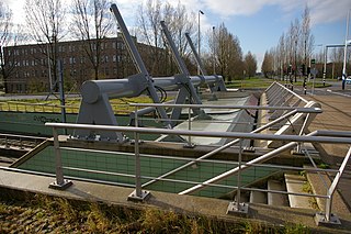
| Description | 'Coupure' under the Bovenkerkerweg in the 'sleeper dike' of the river Amstel in Amstelveen, the Netherlands. Coupures are traverses through dikes for traffic or other nesessary passages that are closed in case of emergencies. A sleeper dike is a secondary dike to contain flooding when the primary dike fails. This coupure was made for the extension of lightrail line 51 from station Poortwachter to station Westwijk in Amstelveen. Steel flaps are normally held in a horizontal position but can be lowered to close the traverse. Picture used on nl:Coupure (waterbouwkunde). |
| Date | |
| Source | Own work |
| Author | MartinD |
Licensing[edit]
I, the copyright holder of this work, hereby publish it under the following licenses:

|
Permission is granted to copy, distribute and/or modify this document under the terms of the GNU Free Documentation License, Version 1.2 or any later version published by the Free Software Foundation; with no Invariant Sections, no Front-Cover Texts, and no Back-Cover Texts. A copy of the license is included in the section entitled GNU Free Documentation License. |
This file is licensed under the Creative Commons Attribution 3.0 Unported license.
- You are free:
- to share – to copy, distribute and transmit the work
- to remix – to adapt the work
- Under the following conditions:
- attribution – You must give appropriate credit, provide a link to the license, and indicate if changes were made. You may do so in any reasonable manner, but not in any way that suggests the licensor endorses you or your use.
You may select the license of your choice.
| Camera location | | View this and other nearby images on: OpenStreetMap |
|---|
File history
Click on a date/time to view the file as it appeared at that time.
| Date/Time | Thumbnail | Dimensions | User | Comment | |
|---|---|---|---|---|---|
| current | 10:04, 23 March 2008 | | 3,008 × 2,000 (1.09 MB) | MartinD (talk | contribs) | {{Information |Description="Coupure" in the dike under the Bovenkerkerweg in Amstelveen, the Netherlands. A coupure is an intentional opening in a dike, generally to facilitate traffic, that can be closed in an emergency. The dike under this road is a "sl |
You cannot overwrite this file.
File usage on Commons
The following page uses this file:
File usage on other wikis
The following other wikis use this file:
- Usage on nl.wikipedia.org