File:Ale stenar 29 maj 2021.jpg
Original file (5,358 × 3,010 pixels, file size: 11.19 MB, MIME type: image/jpeg)
Captions
Summary[edit]
DescriptionAle stenar 29 maj 2021.jpg |
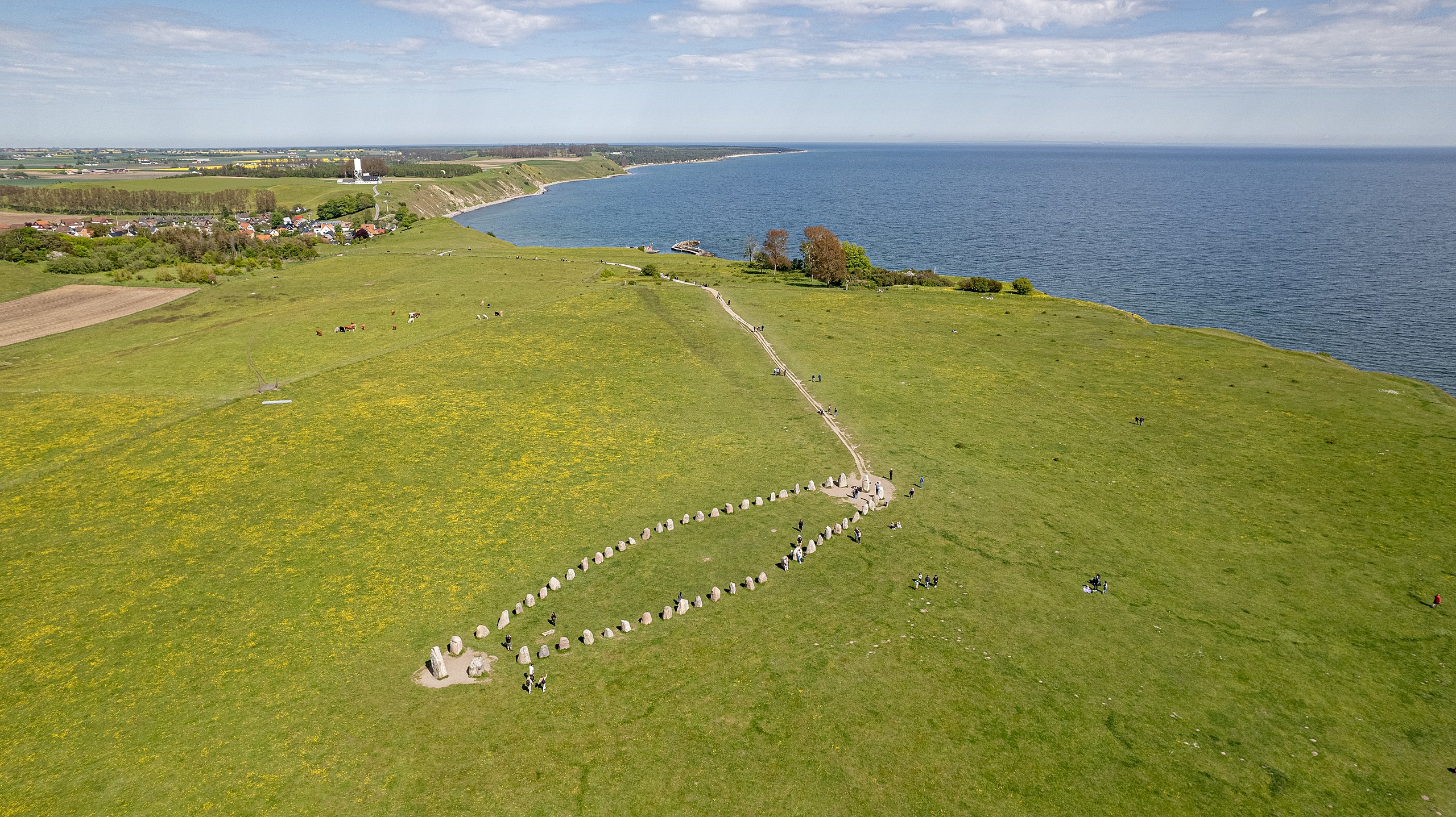
Svenska: Ale stenar fotograferade med drönare.
|
|||
Date | ||||
Source | Own work | |||
Author |
|
Camera location | 55° 22′ 57.54″ N, 14° 03′ 10.09″ E | View this and other nearby images on: OpenStreetMap | 55.382649; 14.052803 |
---|
This aerial photograph has been approved for publishing by the Swedish Armed Forces with the ID: LM2021/017898
|
Licensing[edit]
This file is made available under the Creative Commons CC0 1.0 Universal Public Domain Dedication. | |
The person who associated a work with this deed has dedicated the work to the public domain by waiving all of their rights to the work worldwide under copyright law, including all related and neighboring rights, to the extent allowed by law. You can copy, modify, distribute and perform the work, even for commercial purposes, all without asking permission.
http://creativecommons.org/publicdomain/zero/1.0/deed.enCC0Creative Commons Zero, Public Domain Dedicationfalsefalse |
This image was uploaded as part of Wiki Loves Monuments 2022.
Afrikaans ∙ Alemannisch ∙ azərbaycanca ∙ Bahasa Indonesia ∙ Bahasa Melayu ∙ Bikol Central ∙ bosanski ∙ brezhoneg ∙ català ∙ čeština ∙ Cymraeg ∙ dansk ∙ davvisámegiella ∙ Deutsch ∙ eesti ∙ English ∙ español ∙ Esperanto ∙ euskara ∙ français ∙ Frysk ∙ Gaeilge ∙ galego ∙ hrvatski ∙ Ido ∙ italiano ∙ latviešu ∙ Lëtzebuergesch ∙ Malagasy ∙ magyar ∙ Malti ∙ Nederlands ∙ norsk ∙ norsk nynorsk ∙ norsk bokmål ∙ polski ∙ português ∙ português do Brasil ∙ română ∙ shqip ∙ sicilianu ∙ slovenčina ∙ slovenščina ∙ suomi ∙ svenska ∙ Tagalog ∙ Türkçe ∙ Yorùbá ∙ Zazaki ∙ Ελληνικά ∙ беларуская ∙ беларуская (тарашкевіца) ∙ български ∙ кыргызча ∙ македонски ∙ русский ∙ српски / srpski ∙ українська ∙ ქართული ∙ հայերեն ∙ नेपाली ∙ हिन्दी ∙ বাংলা ∙ മലയാളം ∙ ไทย ∙ 한국어 ∙ +/− |
File history
Click on a date/time to view the file as it appeared at that time.
Date/Time | Thumbnail | Dimensions | User | Comment | |
---|---|---|---|---|---|
current | 14:51, 18 September 2022 | 5,358 × 3,010 (11.19 MB) | Dcastor (talk | contribs) | Uploaded own work with UploadWizard |
You cannot overwrite this file.
File usage on Commons
The following 2 pages use this file:
File usage on other wikis
The following other wikis use this file:
- Usage on da.wikipedia.org
- Usage on sv.wikipedia.org
Metadata
This file contains additional information such as Exif metadata which may have been added by the digital camera, scanner, or software program used to create or digitize it. If the file has been modified from its original state, some details such as the timestamp may not fully reflect those of the original file. The timestamp is only as accurate as the clock in the camera, and it may be completely wrong.
Camera manufacturer | DJI |
---|---|
Camera model | FC3411 |
Author | David Castor |
Exposure time | 1/2,000 sec (0.0005) |
F-number | f/2.8 |
ISO speed rating | 110 |
Date and time of data generation | 15:31, 29 May 2021 |
Lens focal length | 8.38 mm |
Latitude | 55° 22′ 57.54″ N |
Longitude | 14° 3′ 10.09″ E |
Altitude | 27.5 meters below sea level |
Short title |
|
City shown | Löderup |
Horizontal resolution | 240 dpi |
Vertical resolution | 240 dpi |
Software used | Adobe Photoshop Lightroom Classic 11.5 (Windows) |
File change date and time | 16:10, 18 September 2022 |
Exposure Program | Normal program |
Exif version | 2.31 |
Date and time of digitizing | 15:31, 29 May 2021 |
APEX shutter speed | 10.965784 |
APEX aperture | 2.970854 |
APEX exposure bias | 0 |
Maximum land aperture | 2.97 APEX (f/2.8) |
Metering mode | Average |
Light source | Daylight |
Flash | Flash did not fire |
Color space | sRGB |
File source | Digital still camera |
Scene type | A directly photographed image |
Exposure mode | Auto exposure |
White balance | Auto white balance |
Digital zoom ratio | 1 |
Focal length in 35 mm film | 22 mm |
Scene capture type | Standard |
Scene control | None |
Contrast | Normal |
Saturation | Normal |
Sharpness | Normal |
GPS tag version | 0.0.3.2 |
Serial number of camera | 42ULJ1F13A00T2 |
Lens used | 22.4 mm f/2.8 |
Date metadata was last modified | 18:10, 18 September 2022 |
Unique ID of original document | 143E2B0B2820F3270A1FB68A9FB20854 |
Province or state shown | Skåne län |
Country shown | Sverige |
Code for country shown | SE |
IIM version | 4 |
Structured data
Items portrayed in this file
depicts
29 May 2021
55°22'57.536"N, 14°3'10.091"E
0.0005 second
2.8
8.38 millimetre
110
image/jpeg
b61796baa673a48d573cbfcf59b09a84a94b0124
11,731,146 byte
3,010 pixel
5,358 pixel
- Archaeological monuments in Sweden with known IDs
- Images by David Castor-cultural heritage
- Aerial photographs of Sweden approved by the Swedish Defence Forces
- CC-Zero
- Self-published work
- Images from Wiki Loves Monuments 2022
- Images from Wiki Loves Monuments 2022 in Sweden
- Content made available through Wikimedia Sverige competitions
- Images from Wiki Loves Monuments missing SDC creator
- Taken with DJI FC3170
- Uploaded via Campaign:wlm-se-fornmin
- Images by David Castor-WLM 2021
- Pages with maps