File:Airports and seaports map.png
Jump to navigation
Jump to search
Size of this preview: 527 × 600 pixels. Other resolutions: 211 × 240 pixels | 422 × 480 pixels | 1,000 × 1,138 pixels.
Original file (1,000 × 1,138 pixels, file size: 236 KB, MIME type: image/png)
Captions
Captions
Add a one-line explanation of what this file represents
Summary[edit]

|
This economic map image could be re-created using vector graphics as an SVG file. This has several advantages; see Commons:Media for cleanup for more information. If an SVG form of this image is available, please upload it and afterwards replace this template with
{{vector version available|new image name}}.
It is recommended to name the SVG file “Airports and seaports map.svg”—then the template Vector version available (or Vva) does not need the new image name parameter. |
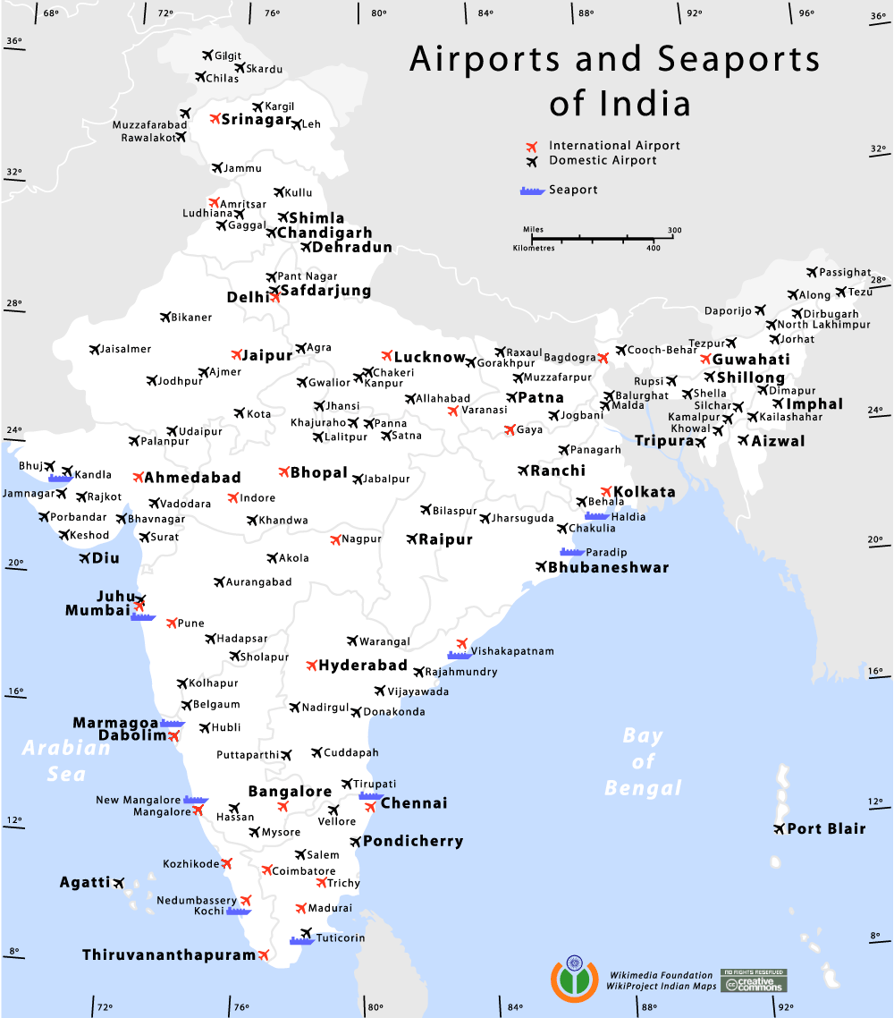
Airports and Seaports map of India
Author[edit]
I, the copyright holder of this work, hereby publish it under the following licenses:

|
Permission is granted to copy, distribute and/or modify this document under the terms of the GNU Free Documentation License, Version 1.2 or any later version published by the Free Software Foundation; with no Invariant Sections, no Front-Cover Texts, and no Back-Cover Texts. A copy of the license is included in the section entitled GNU Free Documentation License. |
| This file is licensed under the Creative Commons Attribution-Share Alike 3.0 Unported license. | ||
| ||
| This licensing tag was added to this file as part of the GFDL licensing update. |
This file is licensed under the Creative Commons Attribution-Share Alike 2.5 Generic, 2.0 Generic and 1.0 Generic license.
- You are free:
- to share – to copy, distribute and transmit the work
- to remix – to adapt the work
- Under the following conditions:
- attribution – You must give appropriate credit, provide a link to the license, and indicate if changes were made. You may do so in any reasonable manner, but not in any way that suggests the licensor endorses you or your use.
- share alike – If you remix, transform, or build upon the material, you must distribute your contributions under the same or compatible license as the original.
You may select the license of your choice.
de:Bild:Airports and seaports map.png
Am confused wid the number of international airports. its 13 here. i had read der r only 11.. which is the correct data?
| Annotations | This image is annotated: View the annotations at Commons |
File history
Click on a date/time to view the file as it appeared at that time.
| Date/Time | Thumbnail | Dimensions | User | Comment | |
|---|---|---|---|---|---|
| current | 20:57, 11 January 2014 | | 1,000 × 1,138 (236 KB) | RaviC (talk | contribs) | +Kargil |
| 20:41, 28 October 2012 |  | 1,000 × 1,138 (263 KB) | RaviC (talk | contribs) | Added all Intl airports not currently listed correctly. | |
| 18:26, 28 October 2012 |  | 1,000 × 1,138 (161 KB) | RaviC (talk | contribs) | Removed vandalism | |
| 05:09, 25 September 2012 |  | 1,000 × 1,138 (256 KB) | Wantsallanger (talk | contribs) | updated international status for srinagar etc as per source http://164.100.47.132/LssNew/psearch/QResult15.aspx?qref=78747 | |
| 18:34, 7 May 2010 |  | 1,000 × 1,138 (180 KB) | RaviC (talk | contribs) | finished adding airports in | |
| 17:29, 7 May 2010 |  | 1,000 × 1,138 (179 KB) | RaviC (talk | contribs) | Added more airports in the Kashmir region | |
| 19:33, 6 May 2010 |  | 1,000 × 1,138 (178 KB) | RaviC (talk | contribs) | Added airports in other areas of Kashmir. However, I cannot add all the names since I don't have the font. | |
| 15:05, 11 January 2006 |  | 1,000 × 1,138 (108 KB) | Planemad (talk | contribs) | Airports and Seaports map of India ==Author== w:user:planemad ==Revision== Original Category:Maps of India Category:Wikiproject Indian Maps |
You cannot overwrite this file.
File usage on Commons
The following page uses this file:
File usage on other wikis
The following other wikis use this file:
- Usage on bh.wikipedia.org
- Usage on bn.wikipedia.org
- Usage on ce.wikipedia.org
- Usage on de.wikipedia.org
- Usage on en.wikipedia.org
- Usage on en.wikivoyage.org
- Usage on fa.wikipedia.org
- Usage on fa.wikivoyage.org
- Usage on fr.wikipedia.org
- Usage on gu.wikipedia.org
- Usage on hi.wikipedia.org
- Usage on hi.wikibooks.org
- Usage on it.wikivoyage.org
- Usage on ja.wikipedia.org
- Usage on kn.wikipedia.org
- Usage on ml.wikipedia.org
- Usage on mr.wikipedia.org
- Usage on new.wikipedia.org
- Usage on nl.wikipedia.org
- Usage on pa.wikipedia.org
- Usage on pl.wikipedia.org
- Usage on ru.wikipedia.org
- Usage on sq.wikipedia.org
- Usage on ta.wikipedia.org
- Usage on te.wikipedia.org
- Usage on zh.wikipedia.org