File:Africa, or Greater Libya WDL142.png
Jump to navigation
Jump to search
Size of this preview: 800 × 520 pixels. Other resolutions: 320 × 208 pixels | 640 × 416 pixels | 1,024 × 665 pixels | 1,280 × 832 pixels | 1,576 × 1,024 pixels.
Original file (1,576 × 1,024 pixels, file size: 2.89 MB, MIME type: image/png)
Captions
Captions
Add a one-line explanation of what this file represents
Summary[edit]
| Author |
Русский: Сансон, Николас (1600-1667)
Français : Sanson, Nicolas (1600-1667)
English: Sanson, Nicolas (1600-1667)
中文:桑松, 尼古拉斯 (1600-1667)
Português: Sanson, Nicolas (1600-1667)
العربية: سانسون، نيكولاس (1600-1667)
Español: Sanson, Nicolas (1600-1667) |
| Title |
Русский: Африка или Великая Ливия
Français : L’Afrique, ou Libye ultérieure
English: Africa, or Greater Libya
中文:非洲或大利比亚
Português: África ou Grande Líbia
العربية: أفريقيا، أو ليبيا الكبرى
Español: África o Gran Libia |
| Description |
Русский: Эта карта Африки работы Николя Сансона, королевского географа при дворе Луи XIII и Луи XIV, который широко известен как основатель французской картографии, была издана Сансоном в его собственном доме в Париже в 1679 году. Согласно Сансону, карта основана на сводных сведениях, почерпнутых из других карт, а также "на наблюдениях Сэмьюэля Бломарта". Дополнительным источником могла также служить работа голландского автора Олферта Даппера 1668 года Naukeurige Beschrijvingen der Afrikaensche gewesten ("Описание Африки"). Континент представлен как "Большая Ливия", а сама карта посвящена главным образом региону Сахары на севере Африки и прилегающим землям западной Африки, простирающимся от Гвинеи и черного побережья до Нубии на востоке.
Африка, западная; Сахара Français : Cette carte de l'Afrique par Nicolas Sanson, géographe royal auprès des rois Louis XIII et Louis XIV et considéré par beaucoup comme le père de la cartographie française, fut publiée par la propre maison de Sanson en 1679 à Paris. Elle était basée, selon Sanson, sur un ensemble de renseignements provenant d'autres cartes, ainsi que « sur les observations de Samuel Blomart ». Elle s’est peut-être inspirée également de l'œuvre de 1668 de l'écrivain néerlandais Olfert Dapper, Naukeurige Beschrijvingen der Afrikaensche gewesten (Description de l'Afrique). Le continent est présenté comme « la Libye ultérieure » et la carte se concentre sur la région saharienne de l'Afrique du Nord et les terres environnantes de l'Afrique de l'Ouest, qui s'étendent depuis la Guinée et la Côte noire jusqu' à la Nubie à l'est.
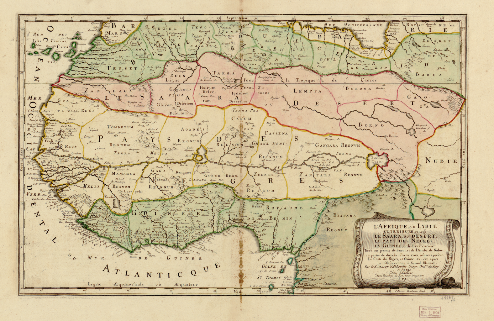
Afrique, Ouest; Sahara English: This map of Africa by Nicolas Sanson, royal geographer to Kings Louis XIII and XIV, and commonly known as the father of French cartography, was published by Sanson’s own house in 1679 in Paris. The map was based, according to Sanson, on a composite of information drawn from other maps as well as “upon the observations of Samuel Blomart.” It also may have drawn on the Dutch writer Olfert Dapper’s work of 1668, Naukeurige Beschrijvingen der Afrikaensche gewesten (Description of Africa). The continent is presented as “Greater Libya” and the map concentrates on the Saharan region of north Africa and the surrounding land of west Africa, stretching from Guinea and the black coast to Nubia in the east.
Africa, West; Sahara 中文:这幅尼古拉斯·桑松制作的非洲地图,由桑松自己的出版公司于 1679 年在巴黎出版,他是国王路易十三和十四时期的皇家地理学家,常被称为法国制图之父。 据桑松所述,这幅地图综合了其他地图的信息以及“塞缪尔·布鲁马特的考察”。 还引用了荷兰作家奥尔福特•达波 1668 年的作品 《Naukeurige Beschrijvingen der Afrikaensche gewesten》 (《非洲描述》)。 大陆部分被称为“大利比亚”,地图集中描述了北非的撒哈拉区域,以及西非周边地区,西起几内亚,经黑海岸,东至努比亚。
西非; 撒哈拉 Português: Este mapa da África por Nicolas Sanson, geógrafo real dos reis Luís XIII e XIV, comumente conhecido como pai da cartografia francesa, foi publicado por Sanson na sua própria casa em Paris no ano de 1679. O mapa inspirou-se, de acordo com Sanson, num composto de informações extraídas de outros mapas, bem como “a partir de observações de Samuel Blomart”. Ele também pode ter sido extraído da obra do escritor holandês Olfert Dapper datada de 1668, Naukeurige Beschrijvingen der Afrikaensche gewesten (Descrição da África). O continente é apresentado como a “Grande Líbia” e o mapa concentra-se na região Saariana ao norte da África e nos territórios adjacentes da África Ocidental, se extendendo da Guiné e a costa negra até a Núbia ao leste.
África, Oeste; Saara العربية: نشرت هذه الخريطة لأفريقيا، والتي رسمها نيكولاس سانسون الجغرافي الملكي الخاص بالملك لويس الثالث عشر والرابع عشر والمعروف باسم الأب المؤسس لعلم رسم الخرائط الفرنسي، على يد دار النشر الخاصة بسانسون عام 1679 في باريس. ووفقا لسانسون، فإن الخريطة ترتكز على تركيبة من المعلومات المستمدة من الخرائط الأخرى فضلا عن "ملاحظات صامويل بلومارت." كما يمكن أن تكون وضعت بناء على عمل الكاتب الهولندي أولفرت دابر في 1668، . وصف أفريقيا. تُبين القارة على أنها "ليبيا العظمى" وتركز الخريطة على منطقة الصحراء الكبرى في شمال أفريقيا وأراضي غرب أفريقيا المحيطة بها التي تمتد من غينيا والساحل الأسود إلى النوبة فى الشرق.
أفريقيا الغربية; الصحراء الكبرى Español: Este mapa de África de Nicolas Sanson, geógrafo real del rey Luis XIII y XIV, y conocido como el padre de la cartografía francesa, fue publicado por la propia casa de Sanson en 1679 en París. El mapa se basaba, según Sanson, en una combinación de información tomada de otros mapas, así como «sobre las observaciones de Samuel Blomart». También puede haber tomado información del trabajo de 1668 del escritor holandés Olfert Dapper, Naukeurige Beschrijvingen der Afrikaensche gewesten (Descripción de África). El continente se presenta como «Gran Libia» y el mapa se centra en la región sahariana del norte de África y las tierras circundantes al oeste de África, desde Guinea y la costa negra hasta Nubia en el este.
África, Occidente; Sahara |
| Date | 1679 |
| Medium |
Русский: Карты
Français : Cartes
English: Maps
中文:地图
Português: Mapas
العربية: خرائط
Español: Mapas |
| Dimensions |
English: 1 map : color ; 33 x 54 centimeters |
| Collection |
Русский: Библиотека Конгресса
Français : Bibliothèque du Congrès
English: Library of Congress
中文:国会图书馆
Português: Biblioteca do Congresso
العربية: مكتبة الكونغرس
Español: Biblioteca del Congreso |
| Place of creation |
Русский: Африка
Français : Afrique
English: Africa
中文:非洲
Português: África
العربية: أفريقيا
Español: África |
| Notes | Original language title: L'Afrique, ou Lybie ulterieure |
| References | http://hdl.loc.gov/loc.wdl/dlc.142 |
| Source/Photographer |
|
Licensing[edit]
|
This is a faithful photographic reproduction of a two-dimensional, public domain work of art. The work of art itself is in the public domain for the following reason:
The official position taken by the Wikimedia Foundation is that "faithful reproductions of two-dimensional public domain works of art are public domain".
This photographic reproduction is therefore also considered to be in the public domain in the United States. In other jurisdictions, re-use of this content may be restricted; see Reuse of PD-Art photographs for details. | ||||
File history
Click on a date/time to view the file as it appeared at that time.
| Date/Time | Thumbnail | Dimensions | User | Comment | |
|---|---|---|---|---|---|
| current | 02:44, 11 March 2014 | | 1,576 × 1,024 (2.89 MB) | Fæ (talk | contribs) | =={{int:filedesc}}== {{Artwork |artist = |author ={{ru|1=Сансон, Николас (1600-1667)}} {{fr|1=Sanson, Nicolas (1600-1667)}} {{en|1=Sanson, Nicolas (1600-1667)}} {{zh|1=桑松, 尼古拉斯 (1600-1667)}} {{pt|1=Sanson, Nicolas (1600-1667)}}... |
You cannot overwrite this file.
File usage on Commons
The following page uses this file: