File:Afghanistan Dust Storm - NASA Earth Observatory.jpg

Original file (720 × 720 pixels, file size: 157 KB, MIME type: image/jpeg)
Captions
Captions
Summary[edit]
| Description |
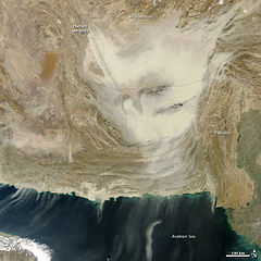
To download the full resolution and other files go to: earthobservatory.nasa.gov/IOTD/view.php?id=76763&src=... A dense cloud of dust swept across southern Afghanistan and Pakistan on December 20, 2011. When the Moderate Resolution Imaging Spectroradiometer (MODIS) took this image from the Terra satellite at 10:45 a.m., the dust was largely hemmed in by the Makran and Sulaiman Ranges in Pakistan with only a few wisps reaching south over the Arabian Sea. By the time Aqua MODIS flew over just over three hours later, the storm had reached the coast. The dust storm continued on December 21. The storm is being propelled by strong winds from the north. The winds picked up dust from the dry lakebeds in the Hamun wetlands on the border between Afghanistan and Iran. Concentrated plumes of dust rise from the pale wetlands to become a more diffuse cloud in the south and east. Dry lakebeds and wetlands are among the most common sources of dust in the world. Dust storms can happen any time of the year in Afghanistan. On average, Afghanistan experiences blowing dust one to two days per month in the winter and six days per month at the height of the summer. Zabon, an Iranian city located near the border in the Hamun wetlands, reports 81 dust storms per year. Blowing dust poses a hazard to transportation. Low visibility closes roads and airports. This particular storm prevented British Prime Minister David Cameron from visiting a British military base as planned because the runway was closed due to low visibility. NASA image courtesy Jeff Schmaltz, LANCE/EOSDIS MODIS Rapid Response Team at NASA GSFC. Caption by Holli Riebeek. The Earth Observatory's mission is to share with the public the images, stories, and discoveries about climate and the environment that emerge from NASA research, including its satellite missions, in-the-field research, and climate models. Like us on Facebook Follow us on Twitter Add us to your circles on Google+ |
| Date | Taken on 20 December 2011, 00:00 |
| Source | Afghanistan Dust Storm |
| Author | NASA's Earth Observatory |
| Camera location | | View this and other nearby images on: OpenStreetMap |
|---|
Licensing[edit]
- You are free:
- to share – to copy, distribute and transmit the work
- to remix – to adapt the work
- Under the following conditions:
- attribution – You must give appropriate credit, provide a link to the license, and indicate if changes were made. You may do so in any reasonable manner, but not in any way that suggests the licensor endorses you or your use.
| This image was originally posted to Flickr by NASA Earth Observatory at https://www.flickr.com/photos/68824346@N02/6554717663. It was reviewed on 2 July 2012 by FlickreviewR and was confirmed to be licensed under the terms of the cc-by-2.0. |
File history
Click on a date/time to view the file as it appeared at that time.
| Date/Time | Thumbnail | Dimensions | User | Comment | |
|---|---|---|---|---|---|
| current | 17:16, 2 July 2012 | | 720 × 720 (157 KB) | Dzlinker (talk | contribs) | == {{int:filedesc}} == {{Information |Description=To download the full resolution and other files go to: [http://earthobservatory.nasa.gov/IOTD/view.php?id=76763&src=flickr earthobservatory.nasa.gov/IOTD/view.php?id=76763&src=...] A dense cloud of dus... |
You cannot overwrite this file.
File usage on Commons
There are no pages that use this file.
File usage on other wikis
The following other wikis use this file:
- Usage on en.wikipedia.org
- Usage on fa.wikipedia.org
- Usage on hi.wikipedia.org
- Usage on ur.wikipedia.org