File:AachenerRevierKarte2.svg
Jump to navigation
Jump to search

Size of this PNG preview of this SVG file: 536 × 599 pixels. Other resolutions: 215 × 240 pixels | 429 × 480 pixels | 687 × 768 pixels | 916 × 1,024 pixels | 1,831 × 2,048 pixels | 896 × 1,002 pixels.
Original file (SVG file, nominally 896 × 1,002 pixels, file size: 65 KB)
Captions
Captions
Add a one-line explanation of what this file represents
Summary[edit]
| Description |
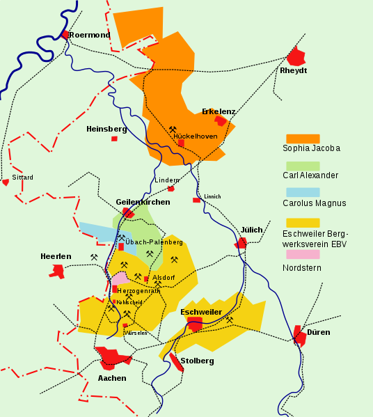
Deutsch: Bergbaukonzessionen des Aachener Reviers im Jahre 1937
English: Coal mining concessions of the Aachener Revier in 1937
Nederlands: Mijnbouwconcessies van het Akens steenkoolbekken in 1937
Norsk bokmål: Gruvekonsesjoner i Gruveområdet i Aachen i 1937 |
| Date | |
| Source | |
| Author |
Eschweiler
|
| Other versions | AachenerRevierKarte2.png |
| This is a retouched picture, which means that it has been digitally altered from its original version. Modifications: converted to SVG, added Nordstern. The original can be viewed here: AachenerRevierKarte1.jpg:
|
Licensing[edit]
I, the copyright holder of this work, hereby publish it under the following license:
This file is licensed under the Creative Commons Attribution-Share Alike 4.0 International license.
- You are free:
- to share – to copy, distribute and transmit the work
- to remix – to adapt the work
- Under the following conditions:
- attribution – You must give appropriate credit, provide a link to the license, and indicate if changes were made. You may do so in any reasonable manner, but not in any way that suggests the licensor endorses you or your use.
- share alike – If you remix, transform, or build upon the material, you must distribute your contributions under the same or compatible license as the original.
File history
Click on a date/time to view the file as it appeared at that time.
| Date/Time | Thumbnail | Dimensions | User | Comment | |
|---|---|---|---|---|---|
| current | 22:22, 3 February 2018 | | 896 × 1,002 (65 KB) | Hans Erren (talk | contribs) | User created page with UploadWizard |
You cannot overwrite this file.
File usage on Commons
The following 5 pages use this file:
File usage on other wikis
The following other wikis use this file:
- Usage on de.wikipedia.org
- Usage on nl.wikipedia.org
- Usage on www.wikidata.org