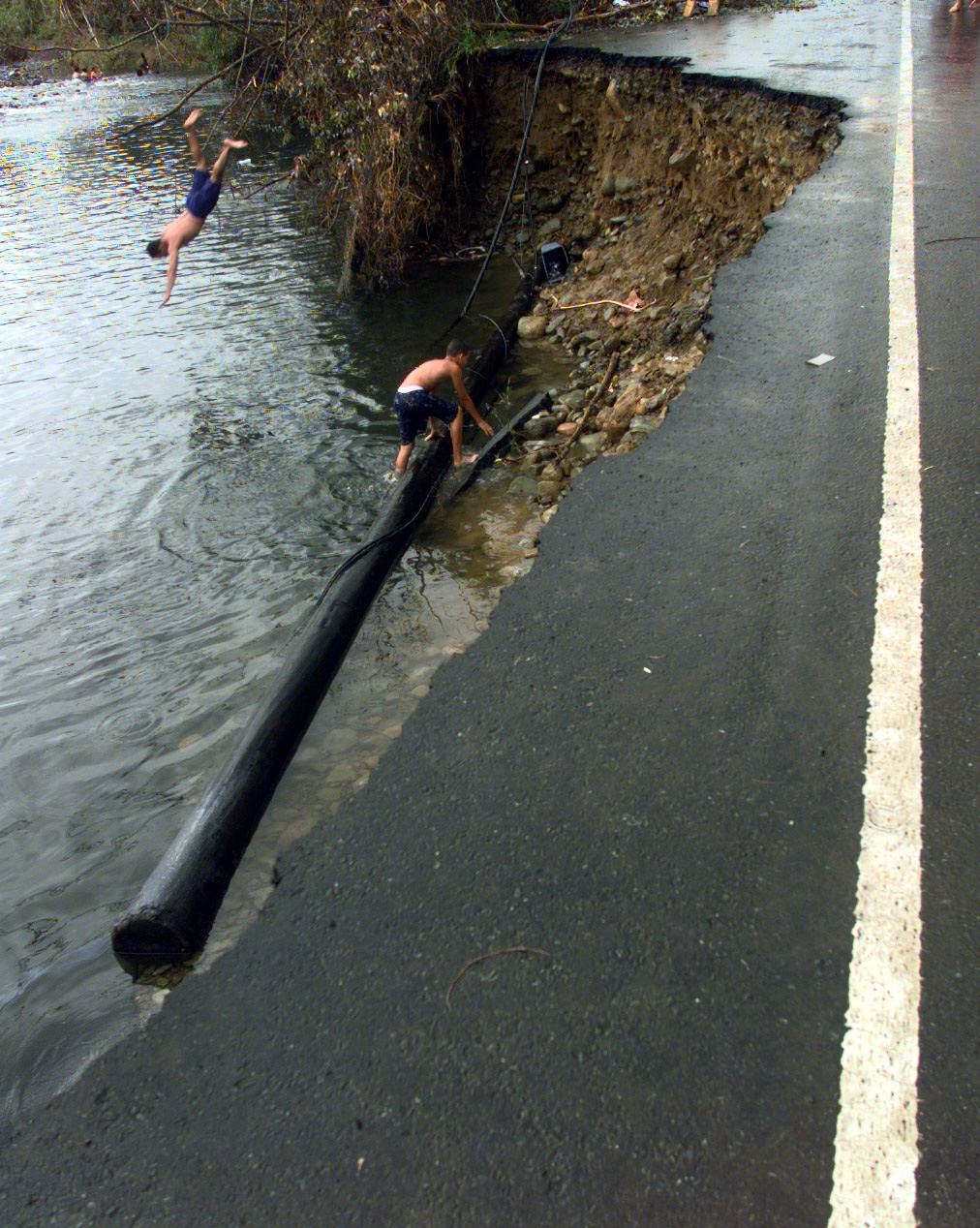
File:A piece of Puerto Rico Route 191, which leads to the small town of Palmer, Puerto Rico in the Carribbean National Forest, collasped into the town's local river. The devastating wind - DPLA - 18495f5152eff8f0335af0269c7abd63.jpeg
Original file (1,012 × 1,268 pixels, file size: 525 KB, MIME type: image/jpeg)
Captions
Summary[edit]
Creator InfoField | Department of Defense. American Forces Information Service. Defense Visual Information Center. 1994 | |||||||||||||||||||
Title |
A piece of Puerto Rico Route 191, which leads to the small town of Palmer, Puerto Rico in the Carribbean National Forest, collasped into the town's local river. The devastating winds of Hurricane Georges ripped through the Island leaving it without electrical power, potable water and phone communications |
|||||||||||||||||||
Description |
The original finding aid described this photograph as: Base: Palmar Country: Puerto Rico (PRI) Scene Camera Operator: SSGT Efrain Gonzalez, USAF Release Status: Released to Public |
|||||||||||||||||||
Date | Taken on 26 September 1998 | |||||||||||||||||||
Collection |
institution QS:P195,Q59661040 |
|||||||||||||||||||
Source/Photographer |
|
|||||||||||||||||||
Permission (Reusing this file) |
|
|||||||||||||||||||
Standardized rights statement InfoField |
|
File history
Click on a date/time to view the file as it appeared at that time.
Date/Time | Thumbnail | Dimensions | User | Comment | |
---|---|---|---|---|---|
current | 15:18, 23 November 2020 | 1,012 × 1,268 (525 KB) | DPLA bot (talk | contribs) | Uploading DPLA ID 18495f5152eff8f0335af0269c7abd63 |
You cannot overwrite this file.
File usage on Commons
The following page uses this file:
Metadata
This file contains additional information such as Exif metadata which may have been added by the digital camera, scanner, or software program used to create or digitize it. If the file has been modified from its original state, some details such as the timestamp may not fully reflect those of the original file. The timestamp is only as accurate as the clock in the camera, and it may be completely wrong.
Image title | A piece of Puerto Rico Route 191, which leads to the small town of Palmer, Puerto Rico in the Carribbean National Forest, collasped into the town's local river. The devastating winds of Hurricane Georges ripped through the Island leaving it without electrical power, potable water and phone communications. |
---|---|
Author | 1st Combat Camera Squadron, SSGT EFRAIN GONZALEZ, USAF |
Source | Digital |
Short title | 980926-F-2352G-008 |
Date and time of data generation | 26 September 1998 |
City shown | PALMAR |
IIM version | 2 |
Writer | L. Costales |
Special instructions | RELEASED |
Country shown | PUERTO RICO (PRI) |
Category | O |
Supplemental categories | UNCLASS |
Keywords |
|
Structured data
Items portrayed in this file
depicts
some value
Reference
A piece of Puerto Rico Route 191, which leads to the small town of Palmer, Puerto Rico in the Carribbean National Forest, collasped into the town's local river. The devastating winds of Hurricane Georges ripped through the Island leaving it without electrical power, potable water and phone communications (English)
Reference
Reference
Reference
The original finding aid described this photograph as: Base: Palmar Country: Puerto Rico (PRI) Scene Camera Operator: SSGT Efrain Gonzalez, USAF Release Status: Released to Public (English)
image/jpeg
61e580f2b2e2eb9f53d14d2e2456d79c8db31dd9
537,093 byte
1,268 pixel
1,012 pixel
- Puerto Rico photographs taken on 1998-09-26
- Taken on missing SDC inception
- Media contributed by the Digital Public Library of America
- Media contributed by the National Archives and Records Administration
- Media contributed by National Archives at College Park - Still Pictures
- PD US Military
- Artworks without Wikidata item
- NARA images of Puerto Rico
- US National Archives series: Combined Military Service Digital Photographic Files, 1982 - 2007
- Files with no machine-readable author