File:A map of part of Alabama & Florida, showing the route of the proposed Columbus & Pensacola Rail Road, accompanying the report of Major J. D. Graham, U.S. Topographical Engr. Feb. 6th, 1836; drawn LOC 98688639.jpg
Jump to navigation
Jump to search

Size of this preview: 558 × 599 pixels. Other resolutions: 223 × 240 pixels | 447 × 480 pixels | 715 × 768 pixels | 954 × 1,024 pixels | 1,907 × 2,048 pixels | 6,347 × 6,816 pixels.
Original file (6,347 × 6,816 pixels, file size: 6.13 MB, MIME type: image/jpeg)
Captions
Captions
Add a one-line explanation of what this file represents
Summary[edit]
| Description |
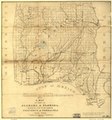
English: Map of southern Alabama and part of western Florida showing roads, cities, and drainage. |
||
| Title | A map of part of Alabama & Florida, showing the route of the proposed Columbus & Pensacola Rail Road, accompanying the report of Major J. D. Graham, U.S. Topographical Engr. Feb. 6th, 1836; drawn chiefly from the original surveys in the Gen. Land Office at Washington by Wm. R. Palmer, U.S. Asst. Civil Engr. | ||
| Shelf ID | G3791.P3 1836 .P3 | ||
| Date | |||
| Source | https://www.loc.gov/item/98688639/ | ||
| Author | Palmer, W. R. (William R.); Graham, J. D. (James Duncan); Columbus And Pensacola Railroad; United States. General Land Office; Palmer, W. R. | ||
| Permission (Reusing this file) |
|
||
| Other versions |
|
||
| Location | United States · Alabama · Florida | ||
| Part of | American Memory · Catalog · Railroad Maps, 1828-1900 · Geography And Map Division · Transportation And Communication | ||
| Subject | Columbus And Pensacola Railroad · Florida · Railroads · United States · Maps · Alabama |

Licensing[edit]
|
This is a faithful photographic reproduction of a two-dimensional, public domain work of art. The work of art itself is in the public domain for the following reason:
The official position taken by the Wikimedia Foundation is that "faithful reproductions of two-dimensional public domain works of art are public domain".
This photographic reproduction is therefore also considered to be in the public domain in the United States. In other jurisdictions, re-use of this content may be restricted; see Reuse of PD-Art photographs for details. | ||||
File history
Click on a date/time to view the file as it appeared at that time.
| Date/Time | Thumbnail | Dimensions | User | Comment | |
|---|---|---|---|---|---|
| current | 23:54, 9 May 2018 | | 6,347 × 6,816 (6.13 MB) | Fæ (talk | contribs) | LOC Maps https://www.loc.gov/item/98688639/ #2142 |
You cannot overwrite this file.
File usage on Commons
The following page uses this file: