File:A Map of the Country round Philadelphia Including Part of New Jersey and New York, 1776 WDL9577.png
Jump to navigation
Jump to search

Size of this preview: 725 × 600 pixels. Other resolutions: 290 × 240 pixels | 580 × 480 pixels | 929 × 768 pixels | 1,238 × 1,024 pixels.
Original file (1,238 × 1,024 pixels, file size: 2.43 MB, MIME type: image/png)
Captions
Captions
Add a one-line explanation of what this file represents
Summary
[edit]
| Title |
Русский: Карта местности вокруг Филадельфии, включая части территорий Нью-Джерси и Нью-Йорка, 1776 г.
Français : Carte de la région de Philadelphie comprenant une partie du New Jersey et de New York, 1776
English: A Map of the Country round Philadelphia Including Part of New Jersey and New York, 1776
中文:费城周边郡县地图,包括新泽西州和纽约部分地区,1776 年
Português: Um mapa do território ao redor da Filadélfia incluindo parte de Nova Jersey e de Nova York, de 1776
العربية: خريطة لأجزاء المنطقة المحيطة بفيلادلفيا، متضمنة جزءاً من نيوجيرسي ونيويورك، 1776
Español: Un mapa del territorio alrededor de Filadelfia que incluye parte de Nueva Jersey y Nueva York, 1776 |
| Description |
Русский: Эта карта восточной части Пенсильвании, Нью-Джерси и территории вокруг города Нью-Йорка была первоначально опубликована в сентябрьском номере журнала "The Gentleman’s Magazine" за 1776 г. Двумя месяцами ранее американские колонии объявили о своей независимости и восстали против британской короны, так что конфликт в Северной Америке представлял повышенный интерес для читателей этого популярного лондонского ежемесячного журнала. В сопроводительной статье были даны объяснения: "Она [карта] охватывает ту часть Америки, которая в настоящее время является главной целью британских войск. Если Нью-Йорк будет внезапно побежден, наиболее вероятно, что следующий удар будет нанесен по Филадельфии, так как расстояние от одного города до другого немногим более четырех дней марша, или восьмидесяти миль, дорога хорошая; и если основная армия под командованием ген. Вашингтона потерпит поражение, сопротивления не будет, или оно будет незначительным. Действительно, поражение, по всей вероятности, положит конец сопротивлению, так как, судя по нынешнему расположению Провинциальной армии, если они будут побеждены, немногим из них удастся спастись". Британцы заняли Нью-Йорк и, как предсказано в статье, двинулись в направлении к Филадельфии. Однако Вашингтон смог отступить из Нью-Йорка и одержать победы при Трентоне 26 декабря 1776 г. и при Принстоне 3 января 1777 г., в целости сохранив свою армию и сражаясь на протяжении следующих шести лет, пока независимость не была обеспечена.
Français : Cette carte de la Pennsylvanie orientale, du New Jersey et de la région de la ville de New York fut publiée dans The Gentleman’s Magazine de septembre 1776. Les colonies américaines avaient déclaré leur indépendance deux mois plus tôt et se soulevaient contre la Couronne britannique, ce qui intéressait vivement les lecteurs de ce populaire mensuel londonien. L'article joint expliquait : « Elle [la carte] représente la partie de l'Amérique qui est désormais la cible principale des armes britanniques. Si New York venait à être affaiblie, il est plus que probable que Philadelphie serait la prochaine attaquée étant donné que la distance entre les deux villes est d'un peu plus de quatre jours de marche, c'est-à-dire quatre-vingts miles (129 kilomètres), la route est bonne et si l'armée principale sous le commandement du gén. Washington est vaincue, aucune opposition ou presque se sera plus à craindre. En effet, une défaite mettrait, selon toute probabilité, fin à l'opposition. Vu le positionnement de l'armée provinciale, si elle venait à être vaincue, peu d'hommes pourraient s'échapper ». Les Britanniques occupèrent New York et, comme le prédisait l'article, se dirigèrent vers Philadelphie. Cependant, Washington fut en mesure de se replier de New York et de remporter des victoires à Trenton le 26 décembre 1776 et à Princeton le 3 janvier 1777, tout en gardant son armée intacte pour poursuivre le combat durant six années supplémentaires, jusqu'à ce que l'indépendance fut acquise.
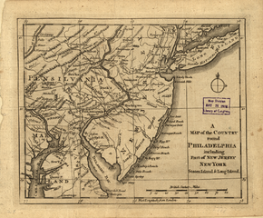
English: This map of eastern Pennsylvania, New Jersey, and the area around New York City originally was published in The Gentleman’s Magazine of September 1776. The American colonies had declared their independence two months earlier and were in revolt against the British crown, so the conflict in North America was of keen interest to readers of this popular London monthly. An accompanying article explained: “It [the map] comprehends that part of America which is now the chief object of the British arms. Should New-York be suddenly reduced, it is more than probable that Philadelphia will be next attacked, as the distance from one city to the other is little more than four days march, or fourscore miles, the road good; and if the main army under Gen. Washington is defeated, little or no opposition is to be dreaded. Indeed, a defeat will, in all probability, put an end to the opposition; for, as the Provincial army is now situated, should they be vanquished, few of them can escape.” The British occupied New York and, as the article predicted, moved toward Philadelphia. But Washington was able to retreat from New York and win victories at Trenton on December 26, 1776, and at Princeton on January 3, 1777, keeping his army intact and fighting for another six years until independence was secured.
中文:这幅宾夕法尼亚州东部、新泽西州以及纽约市周边地区的地图最初刊印在 1776 年 9 月的 The Gentleman’s Magazine(绅士杂志)上。两个月之前,北美殖民地刚刚摆脱英女王统治,宣布独立,这本伦敦畅销月刊正好迎合了读者对北美战事的强烈兴趣。随附的一篇文章如此解释道:“它 [该地图] 认为英国军队的主要目的是占领美国的部分领土。如果纽约被突然攻陷,费城很可能会成为下一个目标,因为纽约与费城仅相距八十英里,而且路况很好,行军只需四天多时间即可抵达;如果华盛顿将军的主力被击败,就几乎消灭掉了全部反抗力量。事实上,一场失利就很有可能毁灭反抗军;因为州军队已经驻扎下来,如果他们受到攻击,逃脱的几率很小”。正如文章所预测,英军将占领纽约后,向费城推进。但华盛顿的军队后来撤出纽约,并赢得了 1776 年 12 月 26 日特伦顿战役的胜利和 1777 年 1 月 3 日普林斯顿战役的胜利,他的军队仍然完整且又坚持再战斗六年,直到获得独立。
Português: Este mapa do leste da Pensilvânia, Nova Jersey, e da área ao redor da Cidade de Nova York foi originalmente publicado na The Gentleman’s Magazine de setembro de 1776. As colônias americanas haviam declarado sua independência dois meses antes e estavam em revolta contra a coroa britânica, portanto o conflito na América do Norte era de grande interesse aos leitores desta popular publicação mensal londrina. Um artigo acompanhando explicava: “Ele [o mapa] compreende parte da América, que é agora o principal objeto das tropas britânicas. Se Nova York for subitamente reduzida, é mais do que provável que a Filadélfia será o alvo do próximo ataque, já que a distância de uma cidade a outra é pouco mais de quatro dias de marcha, ou oitenta milhas, com boas estradas, e se o exército principal sob as ordens do general Washington for derrotado, a oposição pouco ou nada deve ser temida. De fato, uma derrota vai, muito provavelmente, por fim à oposição, pois o exército provincial está agora localizado e, se vencidos, poucos deles poderão escapar”. Os britânicos ocuparam Nova York e, como o artigo previa, moveram-se para a Filadélfia. Mas Washington foi capaz de retirar-se de Nova York e conquistar vitórias em Trenton em 26 de dezembro de 1776, e em Princeton em 3 de janeiro de 1777, mantendo intacto o seu exército, e lutar por mais seis anos até que a independência fosse assegurada.
العربية: نُشرت هذه الخريطة التي تتضمن بنسلفانيا الشرقية ونيو جيرسي والمنطقة التي تحيط بولاية نيويورك، في جينتلمانز ماغازين في سبتمبر عام 1776. وكانت المستعمرات الأمريكية قد أعلنت استقلالها قبل هذا التاريخ بشهرين وكانت تثور ضد بريطانيا، لذلك كان الصراع القائم بأمريكا الشمالية يثير اهتمام قراء هذه المجلة الشهرية الشهيرة. وأوضح المقال المصاحب: "إنها (أي الخريطة) تشمل جزء من أمريكا يُعتبر حالياً الهدف الرئيسي للجيش البريطاني. في حالة خضوع نيويورك فجأة، فهناك احتمال كبير أن يتم الهجوم على فيلادلفيا بعدها مباشرة، وذلك نظراً لأن المسافة من بلدة لأخرى يمكن تجاوزها سيراً على الأقدام خلال أربعة أيام، أو ثمانين ميلاً والطريق جيد؛ وفي حالة هزيمة الجيش الرئيسي بقيادة الجنرال واشنطن، لن يكون هناك خوف من حدوث مقاومة مؤثرة. في الواقع، سيؤدي وقوع الهزيمة، على الأرجح، إلى وضع نهاية للمقاومة؛ وذلك وبالنظر إلى موقع الجيش الإقليمي الحالي، فلن يفلت منهم الكثير إذا ما هزموا." وبالفعل احتل البريطانيون نيويورك، وكما تنبأ المقال، تحركوا في اتجاه فيلادلفيا. ولكن واشنطن تمكن من الهرب من نيويورك وحقق انتصارات في ترينتون في 26 ديسمبر 1776، وفي برنستون في 3 يناير 1777، وبذلك حافظ على جيشه وحارب لمدة ستة أعوام أخرى حتى ضمان الاستقلال.
Español: Este mapa del este de Pensilvania, Nueva Jersey y la zona alrededor de la ciudad de Nueva York fue originalmente publicado en la revista The Gentleman’s Magazine de septiembre de 1776. Las colonias americanas habían declarado su independencia dos meses antes y estaban en rebelión contra la corona británica, por lo que el conflicto en América del Norte fue de gran interés para los lectores de esta revista de Londres de publicación mensual. El artículo que lo acompaña explicaba: «[El mapa] comprende esa parte de América que ahora es el principal objetivo de las armas británicas. En caso de que Nueva York fuera reducida repentinamente, es más que probable que Filadelfia sea la siguiente en ser atacada, ya que la distancia de una ciudad a la otra es un poco más de cuatro días de marcha, o de ochenta millas, la carretera está en buen estado y, si el ejército principal al mando del general Washington es derrotado, debe temerse poca o ninguna oposición. De hecho, todas las probabilidades indican que una derrota pondrá fin a la oposición; de la forma en que está posicionado el ejército provincial, si llega a ser vencido, pocos de ellos podrán escapar». Los británicos ocuparon Nueva York y, como predijo el artículo, se trasladaron a Filadelfia. Sin embargo, Washington consiguió retirarse de Nueva York y lograr victorias en Trenton, el 26 de diciembre de 1776, y en Princeton, el 3 de enero de 1777, mantener intacto a su ejército y luchar por otros seis años hasta asegurar la independencia. |
| Date | 1776 |
| Medium |
Русский: Карты
Français : Cartes
English: Maps
中文:地图
Português: Mapas
العربية: خرائط
Español: Mapas |
| Dimensions |
English: 1 map ; 17 x 21 centimeters |
| Collection |
Русский: Библиотека Конгресса
Français : Bibliothèque du Congrès
English: Library of Congress
中文:国会图书馆
Português: Biblioteca do Congresso
العربية: مكتبة الكونغرس
Español: Biblioteca del Congreso |
| Place of creation |
Русский: Нью-Джерси
Français : New Jersey
English: New Jersey
中文:新泽西州
Português: Nova Jersey
العربية: نيو جيرسي
Español: Nueva Jersey |
| Notes |
Русский: Масштаб прим. 1:1,625,000.
Français : Échelle 1:1 625 000 environ
English: Scale ca. 1:1,625,000.
中文:比例尺约为: 1:1,625,000.
Português: Escala ca. 1:1,625,000.
العربية: المقياس حوالي 1:1,625,000.
Español: Escala ca. 1:1,625 000. |
| References | http://hdl.loc.gov/loc.wdl/dlc.9577 |
| Source/Photographer |
|
Licensing
[edit]
|
This is a faithful photographic reproduction of a two-dimensional, public domain work of art. The work of art itself is in the public domain for the following reason:
The official position taken by the Wikimedia Foundation is that "faithful reproductions of two-dimensional public domain works of art are public domain".
This photographic reproduction is therefore also considered to be in the public domain in the United States. In other jurisdictions, re-use of this content may be restricted; see Reuse of PD-Art photographs for details. | ||||
File history
Click on a date/time to view the file as it appeared at that time.
| Date/Time | Thumbnail | Dimensions | User | Comment | |
|---|---|---|---|---|---|
| current | 03:19, 12 March 2014 | | 1,238 × 1,024 (2.43 MB) | Fæ (talk | contribs) | =={{int:filedesc}}== {{Artwork |artist = |author = |title ={{ru|1=Карта местности вокруг Филадельфии, включая части территорий Нью-Джерси и Нью-Йорка, 1776 г.}} {{fr|1=Carte de la... |
You cannot overwrite this file.
File usage on Commons
The following page uses this file: