File:ACSC CSAA.svg
Jump to navigation
Jump to search

Size of this PNG preview of this SVG file: 508 × 600 pixels. Other resolutions: 203 × 240 pixels | 407 × 480 pixels | 651 × 768 pixels | 867 × 1,024 pixels | 1,735 × 2,048 pixels | 621 × 733 pixels.
Original file (SVG file, nominally 621 × 733 pixels, file size: 504 KB)
Captions
Captions
Add a one-line explanation of what this file represents
Summary[edit]
| Description |
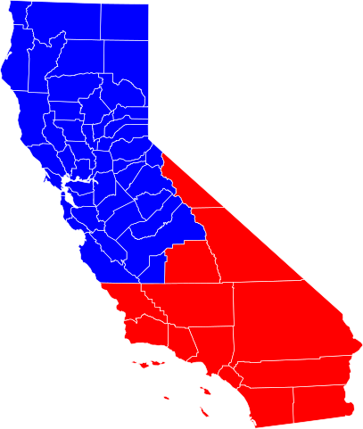
Quick map of the counties in California covered by the Automobile Club of Southern California (red) and California State Automobile Association (CSAA).
|
| Date | |
| Source | ACSC CSAA.png |
| Author | Thadius856 |
| Other versions | ACSC CSAA.png |
| SVG development |
Licensing[edit]
| I, the copyright holder of this work, release this work into the public domain. This applies worldwide. In some countries this may not be legally possible; if so: I grant anyone the right to use this work for any purpose, without any conditions, unless such conditions are required by law. |
File history
Click on a date/time to view the file as it appeared at that time.
| Date/Time | Thumbnail | Dimensions | User | Comment | |
|---|---|---|---|---|---|
| current | 11:35, 24 December 2007 | | 621 × 733 (504 KB) | Thadius856 (talk | contribs) | |
| 11:32, 24 December 2007 |  | 708 × 957 (505 KB) | Thadius856 (talk | contribs) | ||
| 11:31, 24 December 2007 |  | 708 × 957 (505 KB) | Thadius856 (talk | contribs) | {{Information |Description=Quick map of the counties in California covered by the Automobile Club of Southern California (red) and California State Automobile Association (CSAA). Base map is from http://www.nationalatlas.gov/ (public domain). |Source=[[:I |
You cannot overwrite this file.
File usage on Commons
The following page uses this file:
File usage on other wikis
The following other wikis use this file:
- Usage on en.wikipedia.org
- Usage on es.wikipedia.org