File:Rongbuk Glacier animation.gif
Original file (990 × 610 pixels, file size: 1.68 MB, MIME type: image/gif, looped, 4 frames, 3.2 s)
Captions
Captions
Summary[edit]
| Description |
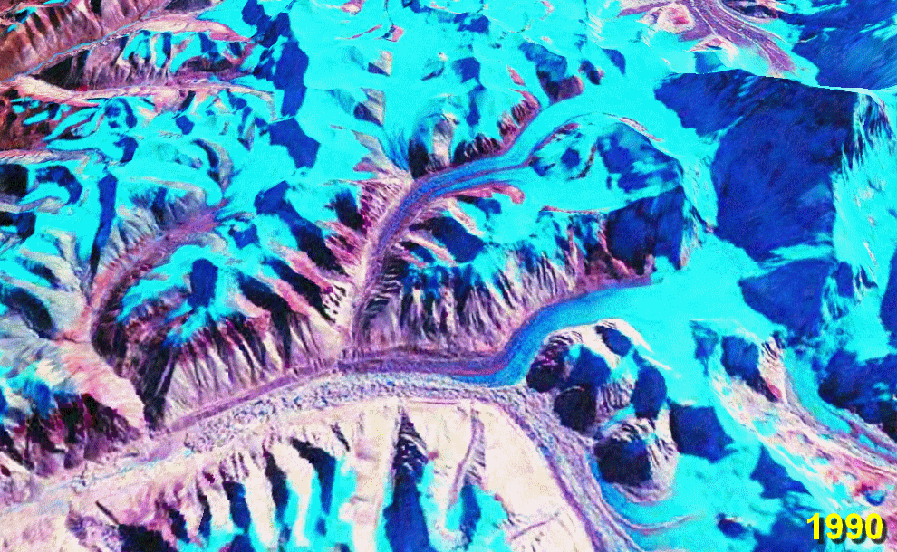
English: Rongbuk (Rongphu) Glacier, Tibet; Mount Everest at the top right.
The lower ~10 km of the glacier is moraine-covered. Its terminus (snout) is near the bottom left at the source of the Rongbuk River. There is no snout retreat over this interval, but the large increase in the area of meltwater lakes on the glacier surface suggests significant thinning. The big lake in the 2010 image is nearly 2 km long. Also note the reduction in glacier cover on the foothills to the left. Stacked NASA World Wind images from the 1990 and 2000 NASA GeoCover collections and USGS Landsat 7 imagery from October 2009[1] (all Landsat 4/5 and Landsat 7 MSS/TM/ETM+ false-colour images). Diagonal lines in the 2010 image are due to the ETM+ scan line correction failure on Landsat 7. worldwind://goto/world=Earth&lat=28.07778&lon=86.88972&alt=19166&dir=92.2&tilt=31.6 (This is an animated GIF image. If animation is not visible, it may be because Microsoft Office Picture Manager has your GIF file association. That application does not support GIF animation. Change the association to any standard picture viewer, and restart your browser.) |
| Date | 28 September 2006 (original upload date) |
| Source | Own work. Made with NASA World Wind from NASA public domain imagery |
| Author | Glen Fergus |
Related glacier retreat images:[edit]
|


Licensing[edit]
Made with NASA World Wind from NASA public domain imagery

|
Permission is granted to copy, distribute and/or modify this document under the terms of the GNU Free Documentation License, Version 1.2 or any later version published by the Free Software Foundation; with no Invariant Sections, no Front-Cover Texts, and no Back-Cover Texts. A copy of the license is included in the section entitled GNU Free Documentation License. |
| This file is licensed under the Creative Commons Attribution-Share Alike 3.0 Unported license. | ||
| ||
| This licensing tag was added to this file as part of the GFDL licensing update. |
File history
Click on a date/time to view the file as it appeared at that time.
| Date/Time | Thumbnail | Dimensions | User | Comment | |
|---|---|---|---|---|---|
| current | 06:11, 29 January 2010 | | 990 × 610 (1.68 MB) | Glen Fergus (talk | contribs) | Version 2 - 2010 |
| 11:07, 28 September 2006 |  | 992 × 654 (950 KB) | Glen Fergus (talk | contribs) | == Summary == Rongbuk Glacier, Tibet. Mount Everest at the top right. The is no snout retreat over this interval, but the large increase in the area of meltwater lakes suggests significant thinning. Stacked NASA [[w:en:World W |
You cannot overwrite this file.
File usage on Commons
The following 23 pages use this file:
- File:86.88972E 28.07778N.gif (file redirect)
- File:Tasman Glacier.gif
- File:Puncak Jaya glaciers animation.gif
- File:Aletsch Glacier animation.gif
- File:Athabasca Glacier animation.gif
- File:Umiamako Glacier animation.gif
- File:San Rafael Glacier animation.gif
- File:Baltoro Glacier animation.gif
- File:Qori Kalis Glacier animation.gif
- File:Laguna San Rafael National Park glaciers animation.gif
- File:Southern Alps glaciers animation.gif
- File:Glacier Grey animation.gif
- File:Aletsch Glacier animation.gif
- File:Athabasca Glacier animation.gif
- File:Baltoro Glacier animation.gif
- File:Glacier Grey animation.gif
- File:Laguna San Rafael National Park glaciers animation.gif
- File:Puncak Jaya glaciers animation.gif
- File:Qori Kalis Glacier animation.gif
- File:San Rafael Glacier animation.gif
- File:Southern Alps glaciers animation.gif
- File:Tasman Glacier.gif
- File:Umiamako Glacier animation.gif
File usage on other wikis
The following other wikis use this file:
- Usage on az.wikipedia.org
- Usage on cs.wikipedia.org
- Usage on en.wikipedia.org
- Usage on es.wikipedia.org
- Usage on it.wikipedia.org
- Usage on ml.wikipedia.org
- Usage on ru.wikipedia.org
- Usage on uk.wikipedia.org
- Usage on zh.wikipedia.org