File:4D-RCS Five levels of the architecture for Demo III..jpg
Jump to navigation
Jump to search
Size of this preview: 436 × 600 pixels. Other resolutions: 174 × 240 pixels | 349 × 480 pixels | 941 × 1,294 pixels.
Original file (941 × 1,294 pixels, file size: 210 KB, MIME type: image/jpeg)
Captions
Captions
Add a one-line explanation of what this file represents
Summary[edit]
| Description |
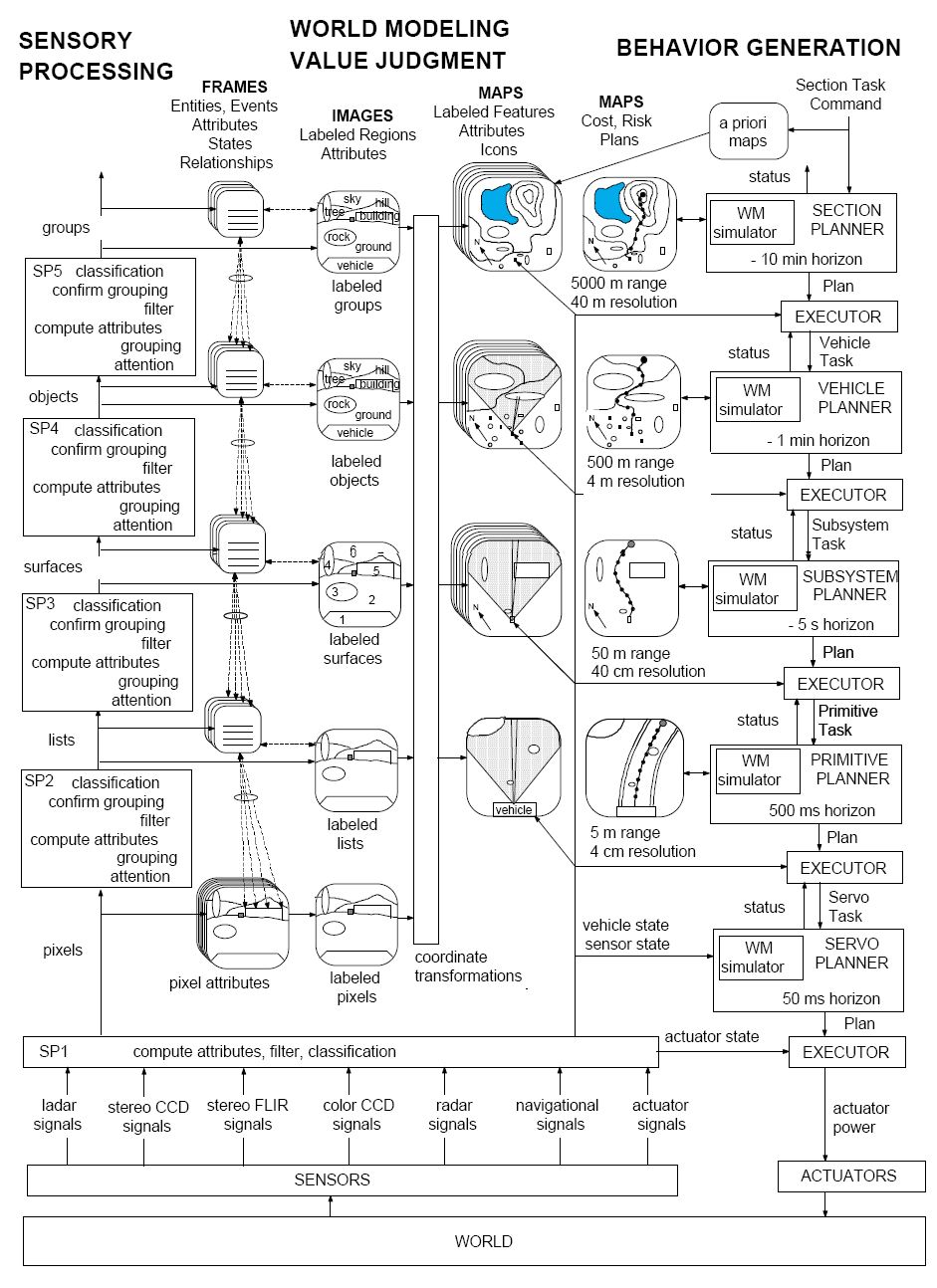
English: Five levels of the 4D/RCS architecture for Demo III.
On the right are Planner and Executor modules. In the center are maps for representing terrain features, road, bridges, vehicles, friendly/enemy positions, and the cost and risk of traversing various regions. On the left are Sensory Processing functions, symbolic representations of entities and events, and segmented images with labeled regions. The coordinate transforms in the middle use range information to assign labeled regions in the entity image hierarchy on the left to locations on planning maps on the right. This causes the entity class hierarchy on the left to be orthogonal to the BG process hierarchy on the right. |
| Date | |
| Source | 4D-RCS A Reference Model Architecture For Unmanned Vehicle Systems Version 2.0 |
| Author | Albus et al. National Institute of Standards and Technology, Gaithersburg, Maryland 20899 |
Licensing[edit]
This work is in the public domain in the United States because it is a work prepared by an officer or employee of the United States Government as part of that person’s official duties under the terms of Title 17, Chapter 1, Section 105 of the US Code.
Note: This only applies to original works of the Federal Government and not to the work of any individual U.S. state, territory, commonwealth, county, municipality, or any other subdivision. This template also does not apply to postage stamp designs published by the United States Postal Service since 1978. (See § 313.6(C)(1) of Compendium of U.S. Copyright Office Practices). It also does not apply to certain US coins; see The US Mint Terms of Use.
|
 | |
| This file has been identified as being free of known restrictions under copyright law, including all related and neighboring rights. | ||
File history
Click on a date/time to view the file as it appeared at that time.
| Date/Time | Thumbnail | Dimensions | User | Comment | |
|---|---|---|---|---|---|
| current | 23:28, 2 August 2009 | | 941 × 1,294 (210 KB) | Mdd (talk | contribs) | {{Information |Description={{en|1=Five levels of the 4D/RCS architecture for Demo III. On the right are Planner and Executor modules. In the center are maps for representing terrain features, road, bridges, vehicles, friendly/enemy positions, and the cost |
You cannot overwrite this file.
File usage on Commons
The following page uses this file:
File usage on other wikis
The following other wikis use this file:
- Usage on en.wikipedia.org