File:2024-12-24 Pegel Altenau I Wasserstand.png
Jump to navigation
Jump to search

Size of this preview: 800 × 410 pixels. Other resolutions: 320 × 164 pixels | 640 × 328 pixels | 1,165 × 597 pixels.
Original file (1,165 × 597 pixels, file size: 89 KB, MIME type: image/png)
Captions
Captions
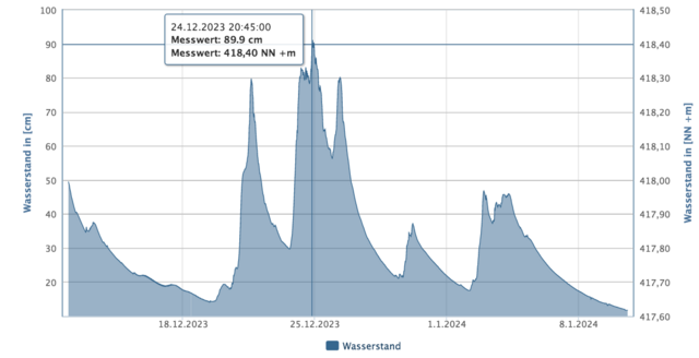
Water level of the Altenau I gauge during the 2023 Christmas flood
Summary[edit]
| Description |
Deutsch: Die Pegelmessung an der Oker in Altenau kurz vor dem Einlauf in die Okertalsperre dient als Indikator für den gesamten Zulauf in die Okertalsperre, d.h. es ist eine Hochrechnung über alle Gewässer, die in der Talsperre münden. |
| Date | |
| Source | https://www.pegelonline.nlwkn.niedersachsen.de/Pegel/Binnenpegel/ID/154 |
| Author | Niedersächsischer Landesbetrieb für Wasserwirtschaft, Küsten- und Naturschutz |
| Camera location | | View this and other nearby images on: OpenStreetMap |
|---|
Licensing[edit]
| This chart is ineligible for copyright and therefore in the public domain, because it consists entirely of information that is common property and contains no original authorship. For more information, see Commons:Threshold of originality § Charts
|
Screenshot of a simple chart representing measurement data
File history
Click on a date/time to view the file as it appeared at that time.
| Date/Time | Thumbnail | Dimensions | User | Comment | |
|---|---|---|---|---|---|
| current | 22:17, 10 January 2024 | | 1,165 × 597 (89 KB) | Gunnar.Kaestle (talk | contribs) | Uploaded a work by Niedersächsischer Landesbetrieb für Wasserwirtschaft, Küsten- und Naturschutz from https://www.pegelonline.nlwkn.niedersachsen.de/Pegel/Binnenpegel/ID/154 with UploadWizard |
You cannot overwrite this file.
File usage on Commons
There are no pages that use this file.
File usage on other wikis
The following other wikis use this file:
- Usage on de.wikipedia.org