File:2009 Ohio General Election Issue 3.svg
Jump to navigation
Jump to search

Size of this PNG preview of this SVG file: 551 × 599 pixels. Other resolutions: 221 × 240 pixels | 442 × 480 pixels | 706 × 768 pixels | 942 × 1,024 pixels | 1,884 × 2,048 pixels | 3,675 × 3,995 pixels.
Original file (SVG file, nominally 3,675 × 3,995 pixels, file size: 277 KB)
Captions
Captions
Add a one-line explanation of what this file represents
| Description |
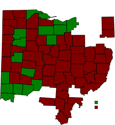
The original file used to create this map was a locator map showing Stark County in Ohio. David Benbennick made this map. For more information, see Commons:United States county locator maps. On November 3, 2009, Ohioans went to the polls to cast their vote on three referendums, as well as many local issues and candidates. This map shows a county-by-county result of Issue 3, which allows four casinos to be constructed in Ohio. |
| Date | (UTC) |
| Source | |
| Author |
|
I, the copyright holder of this work, hereby publish it under the following license:
| I, the copyright holder of this work, release this work into the public domain. This applies worldwide. In some countries this may not be legally possible; if so: I grant anyone the right to use this work for any purpose, without any conditions, unless such conditions are required by law. |
Original upload log[edit]
This image is a derivative work of the following images:
- File:Map_of_Ohio_highlighting_Stark_County.svg licensed with PD-self
- 2006-02-12T16:11:02Z David Benbennick 3675x3995 (59501 Bytes) {{subst:User:Dbenbenn/clm|county=Stark County|state=Ohio|type=county}}
Uploaded with derivativeFX
File history
Click on a date/time to view the file as it appeared at that time.
| Date/Time | Thumbnail | Dimensions | User | Comment | |
|---|---|---|---|---|---|
| current | 03:00, 8 November 2009 | | 3,675 × 3,995 (277 KB) | Navie05~commonswiki (talk | contribs) | {{Information |Description=The original file used to create this map was a locator map showing Stark County in Ohio. David Benbennick made this map. For more information, see [[Commons:United States county loca |
You cannot overwrite this file.
File usage on Commons
There are no pages that use this file.