File:2008, Swing States.svg
Jump to navigation
Jump to search

Size of this PNG preview of this SVG file: 800 × 465 pixels. Other resolutions: 320 × 186 pixels | 640 × 372 pixels | 1,024 × 595 pixels | 1,280 × 744 pixels | 2,560 × 1,488 pixels | 1,020 × 593 pixels.
Original file (SVG file, nominally 1,020 × 593 pixels, file size: 119 KB)
Captions
Captions
Add a one-line explanation of what this file represents
Summary[edit]

|
This file has been superseded by Swing states, 2008.svg. It is recommended to use the other file. Please note that deleting superseded images requires consent.
|

|
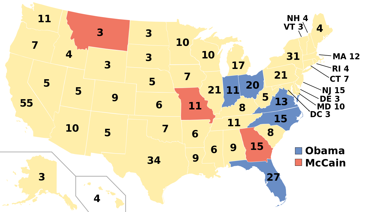
| Description | A blank map of the United States in scalable vector form. Edited in Inkscape.States in the 2008 United States Presidential election where the margin of victory was 6% or less. Blue states went for Obama, red for McCain. White states were won by either candidate by 6% or more. This image is based off this image from Wikipedia (now Commons), which in turn is based off this image from the Commons. |
| Date | (UTC) |
| Source | |
| Author | |
| Other versions |
Labelled US map.svg This map with state labels |
| SVG development |
Licensing[edit]

|
Permission is granted to copy, distribute and/or modify this document under the terms of the GNU Free Documentation License, Version 1.2 or any later version published by the Free Software Foundation; with no Invariant Sections, no Front-Cover Texts, and no Back-Cover Texts. A copy of the license is included in the section entitled GNU Free Documentation License. |
| This file is licensed under the Creative Commons Attribution-Share Alike 3.0 Unported license. | ||
| ||
| This licensing tag was added to this file as part of the GFDL licensing update. |
Original upload log[edit]
This image is a derivative work of the following images:
- Blank US Map.svg licensed with GFDL, GFDL/en
- 2008-10-09T16:36:40Z Howcheng 959x593 (80121 Bytes) Reverted to version as of 08:32, 14 June 2007
- 2008-03-12T00:20:02Z AMK1211 959x593 (174744 Bytes) Added borders: Light blue for water borders and black for land borders (international borders thicker).
- 2007-06-14T08:32:47Z Fibonacci 959x593 (80121 Bytes) Optimised code.
- 2006-07-12T23:00:30Z Theshibboleth 959x593 (90537 Bytes) The line framework around Alaska and Hawaii has been pushed a bit
- 2006-07-12T06:35:19Z Theshibboleth 959x593 (89828 Bytes) added DC
- 2006-07-12T06:05:05Z Theshibboleth 959x593 (89649 Bytes) {{Information |Description=A blank map of the United States in scalable vector form. |Source={{own}}, based on [[:Image:Electorial map.svg]], inspired by [[:Image:BlankMap-World.png]] |Date=11 July 2006 |Author=[[User:Theshi
- Swing states, 2004.svg licensed with PD-self
Uploaded with derivativeFX
File history
Click on a date/time to view the file as it appeared at that time.
| Date/Time | Thumbnail | Dimensions | User | Comment | |
|---|---|---|---|---|---|
| current | 07:44, 3 January 2009 | | 1,020 × 593 (119 KB) | Mekeritrig (talk | contribs) | {{Information |Description=A blank map of the United States in scalable vector form. Edited in Inkscape.States in the 2008 United States Presidential election where the margin of victory was 6% or less. Blue states went for Obama, red for McCain. White st |
You cannot overwrite this file.
File usage on Commons
There are no pages that use this file.
File usage on other wikis
The following other wikis use this file:
- Usage on hu.wikipedia.org