File:2003 California gubernatorial recall election replacement results map by county.svg
Jump to navigation
Jump to search

Size of this PNG preview of this SVG file: 600 × 600 pixels. Other resolutions: 240 × 240 pixels | 480 × 480 pixels | 768 × 768 pixels | 1,024 × 1,024 pixels | 2,048 × 2,048 pixels | 810 × 810 pixels.
Original file (SVG file, nominally 810 × 810 pixels, file size: 63 KB)
Captions
Captions
Add a one-line explanation of what this file represents
Summary[edit]
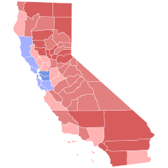
| Description |
Results of the 2003 California gubernatorial recall election 40-50%
50-60%
60-70%
Bustamante 40-50%
50-60%
60-70% |
||
| Date | 4 September 2018 (upload date) | ||
| Source |
Based on File:2000nationwidecountymapshadedbyvoteshare.svg by Inqvisitor; data from OurCampaigns.com and USElectionAtlas.org This W3C-unspecified vector image was created with Inkscape . |
||
| Author |
|
||
| Permission (Reusing this file) |
|
Licensing[edit]
I, the copyright holder of this work, hereby publish it under the following license:
This file is licensed under the Creative Commons Attribution-Share Alike 4.0 International license.
- You are free:
- to share – to copy, distribute and transmit the work
- to remix – to adapt the work
- Under the following conditions:
- attribution – You must give appropriate credit, provide a link to the license, and indicate if changes were made. You may do so in any reasonable manner, but not in any way that suggests the licensor endorses you or your use.
- share alike – If you remix, transform, or build upon the material, you must distribute your contributions under the same or compatible license as the original.
File history
Click on a date/time to view the file as it appeared at that time.
| Date/Time | Thumbnail | Dimensions | User | Comment | |
|---|---|---|---|---|---|
| current | 12:38, 15 August 2023 | | 810 × 810 (63 KB) | Putitonamap98 (talk | contribs) | shapes |
| 02:12, 2 October 2021 |  | 744 × 744 (599 KB) | Fluffy89502 (talk | contribs) | county lines | |
| 09:49, 31 October 2018 |  | 512 × 666 (26 KB) | Crazytonyi (talk | contribs) | Two maps that are only semi-related should be handled as two separate images. Also, when second map is added, annotation on what it is a map of and what the color codes indicate need to be present. Reverted to version as of 00:17, 4 September 2018 (UTC) | |
| 00:25, 4 September 2018 |  | 512 × 341 (61 KB) | Pharexia (talk | contribs) | added results of recall | |
| 00:17, 4 September 2018 |  | 512 × 666 (26 KB) | Pharexia (talk | contribs) | User created page with UploadWizard |
You cannot overwrite this file.
File usage on Commons
The following 4 pages use this file:
File usage on other wikis
The following other wikis use this file:
- Usage on en.wikipedia.org
- Usage on es.wikipedia.org
- Usage on sr.wikipedia.org