File:19870915031NR Güstrow Schloß.jpg

Original file (3,000 × 2,129 pixels, file size: 2.64 MB, MIME type: image/jpeg)
Captions
Captions
Contents
Summary
Object
| Güstrow Castle
|
||||
|---|---|---|---|---|
| Artist |
Franz Parr 1558 begonnen Philipp Brandin 1587-1589 Nordflügel |
|||
| Title |
Güstrow Castle label QS:Lit,"Castello Güstrow"
label QS:Lfr,"Château de Güstrow"
label QS:Lceb,"Güstrower Schloss"
label QS:Leu,"Güstrowko jauregia"
label QS:Lnl,"Kasteel Güstrow"
label QS:Lru,"Гюстровский замок"
label QS:Lde,"Schloss Güstrow"
label QS:Lpt,"Castelo de Güstrow"
label QS:Len,"Güstrow Castle"
label QS:Les,"Palacio de Güstrow"
label QS:Lzh,"居斯特羅宮"
label QS:Lda,"Güstrow Slot" |
|||
| Part of |
Staatliches Museum Schwerin |
|||
| Object type |
château / museum |
|||
| Description |
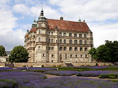
Deutsch: 15.09.1987 DDR 2600 [18273] Güstrow, Franz-Parr-Platz 1: Renaissanceschloß (GMP: 12.176455,12.177249). Unvollendete 4-Flügel-Anlage. Von 1628-1630 resiedierte der kaiserliche Generalissimus Albrecht von Wallenstein als mecklenburgischer Herzog im Güstrower Schloß. 1963-1978 erfolgte in der DDR eine umfassende Restaurierung des Schlosses. Schloß Güstrow gilt als eines der bedeutendsten Renaissancebauwerke Norddeutschlands. Sicht von Süden. [R19870914B12.JPG]19870915031.NR.JPG(c)Blobelt |
|||
| Date |
1558 Franz Parr bis 1566 vollendet West- und Südflügel 1587-1589 Philipp Brandin Nordflügel |
|||
| Object location |
|
|||
| Authority file | ||||
| Other versions |
|
|||
Photograph
| Description19870915031NR Güstrow Schloß.jpg | |||||||||||||||
| Date | |||||||||||||||
| Source | Own work | ||||||||||||||
| Author |
creator QS:P170,Q28598952 |
||||||||||||||
| Object location | 53° 47′ 26.88″ N, 12° 10′ 38.1″ E | View this and other nearby images on: OpenStreetMap |
|---|

|
This image was uploaded as part of Wiki Loves Monuments 2021.
Afrikaans ∙ Alemannisch ∙ azərbaycanca ∙ Bahasa Indonesia ∙ Bahasa Melayu ∙ Bikol Central ∙ bosanski ∙ brezhoneg ∙ català ∙ čeština ∙ Cymraeg ∙ dansk ∙ davvisámegiella ∙ Deutsch ∙ eesti ∙ English ∙ español ∙ Esperanto ∙ euskara ∙ français ∙ Frysk ∙ Gaeilge ∙ galego ∙ hrvatski ∙ Ido ∙ italiano ∙ latviešu ∙ Lëtzebuergesch ∙ Malagasy ∙ magyar ∙ Malti ∙ Nederlands ∙ norsk ∙ norsk nynorsk ∙ norsk bokmål ∙ polski ∙ português ∙ português do Brasil ∙ română ∙ shqip ∙ sicilianu ∙ slovenčina ∙ slovenščina ∙ suomi ∙ svenska ∙ Tagalog ∙ Türkçe ∙ Yorùbá ∙ Zazaki ∙ Ελληνικά ∙ беларуская ∙ беларуская (тарашкевіца) ∙ български ∙ кыргызча ∙ македонски ∙ русский ∙ српски / srpski ∙ українська ∙ ქართული ∙ հայերեն ∙ नेपाली ∙ हिन्दी ∙ বাংলা ∙ മലയാളം ∙ ไทย ∙ 한국어 ∙ +/− |
 |
Licensing
- You are free:
- to share – to copy, distribute and transmit the work
- to remix – to adapt the work
- Under the following conditions:
- attribution – You must give appropriate credit, provide a link to the license, and indicate if changes were made. You may do so in any reasonable manner, but not in any way that suggests the licensor endorses you or your use.
- share alike – If you remix, transform, or build upon the material, you must distribute your contributions under the same or compatible license as the original.
File history
Click on a date/time to view the file as it appeared at that time.
| Date/Time | Thumbnail | Dimensions | User | Comment | |
|---|---|---|---|---|---|
| current | 12:29, 5 September 2021 |  | 3,000 × 2,129 (2.64 MB) | Jörg Blobelt (talk | contribs) | Uploaded a work by {{Creator:Jörg Blobelt}} from {{own}} with UploadWizard |
You cannot overwrite this file.
File usage on Commons
The following page uses this file:
Metadata
This file contains additional information such as Exif metadata which may have been added by the digital camera, scanner, or software program used to create or digitize it. If the file has been modified from its original state, some details such as the timestamp may not fully reflect those of the original file. The timestamp is only as accurate as the clock in the camera, and it may be completely wrong.
| Camera manufacturer | HP |
|---|---|
| Camera model | HP Scanjet 4800 |
| Date and time of data generation | 19:18, 7 March 2013 |
| Image title | 15.09.1987 DDR 2600 [18273] Güstrow, Franz-Parr-Platz 1: Renaissanceschloß (GMP: 12.176455,12.177249). Unvollendete 4-Flügel-Anlage, begonnen 1558 von Franz Parr. West- und Südflügel bis 1566 vollendet. Nordflügel 1587-1589 von Philipp Brandin. Von 1628-1630 resiedierte der kaiserliche Generalissimus Albrecht von Wallenstein als mecklenburgischer Herzog im Güstrower Schloß. 1963-1978 erfolgte in der DDR eine umfassende Restaurierung des Schlosses. Schloß Güstrow gilt als eines der bedeutendsten Renaissancebauwerke Norddeutschlands. Sicht von Süden. [R19870914B12.JPG]19870915031.NR.JPG(c)Blobelt |
| Copyright holder | Dr. Jörg Blobelt (retret 05.09.2021) |
| Horizontal resolution | 300 dpi |
| Vertical resolution | 300 dpi |
| Y and C positioning | Co-sited |
| Pair of black and white reference values |
|
| Exif version | 2.2 |
| Meaning of each component |
|
| Supported Flashpix version | 1 |
| Color space | sRGB |
| Saturation | Normal |
| Sharpness | Normal |
| IIM version | 2 |
Structured data
Items portrayed in this file
depicts
15 September 1987
53°47'26.9"N, 12°10'37.9"E
image/jpeg
5e2e6417a5c6a2544d270613d1d7e508700c7d8d
2,768,226 byte
2,129 pixel
3,000 pixel
- Artworks with Wikidata item
- Artworks with Wikidata item missing genre
- Artworks with Wikidata item missing artist
- Artworks main subject type unknown type of work
- Files with coordinates missing SDC location of creation
- Images from Wiki Loves Monuments 2021
- Images from Wiki Loves Monuments 2021 in Germany
- Images from Wiki Loves Monuments missing SDC location of creation
- Images from Wiki Loves Monuments missing SDC creator
- CC-BY-SA-4.0
- Files by Jörg Blobelt
- Images from Wiki Loves Monuments 2021, DE-MV
- Pages with maps


