File:1853 U.S. Coast Survey Map of the West Coast of the United States - Geographicus - WestCoast2-uscs-1853.jpg
Jump to navigation
Jump to search
Size of this preview: 614 × 599 pixels. Other resolutions: 246 × 240 pixels | 492 × 480 pixels | 787 × 768 pixels | 1,049 × 1,024 pixels | 2,098 × 2,048 pixels | 5,000 × 4,881 pixels.
Original file (5,000 × 4,881 pixels, file size: 4.81 MB, MIME type: image/jpeg)
Captions
Captions
Add a one-line explanation of what this file represents
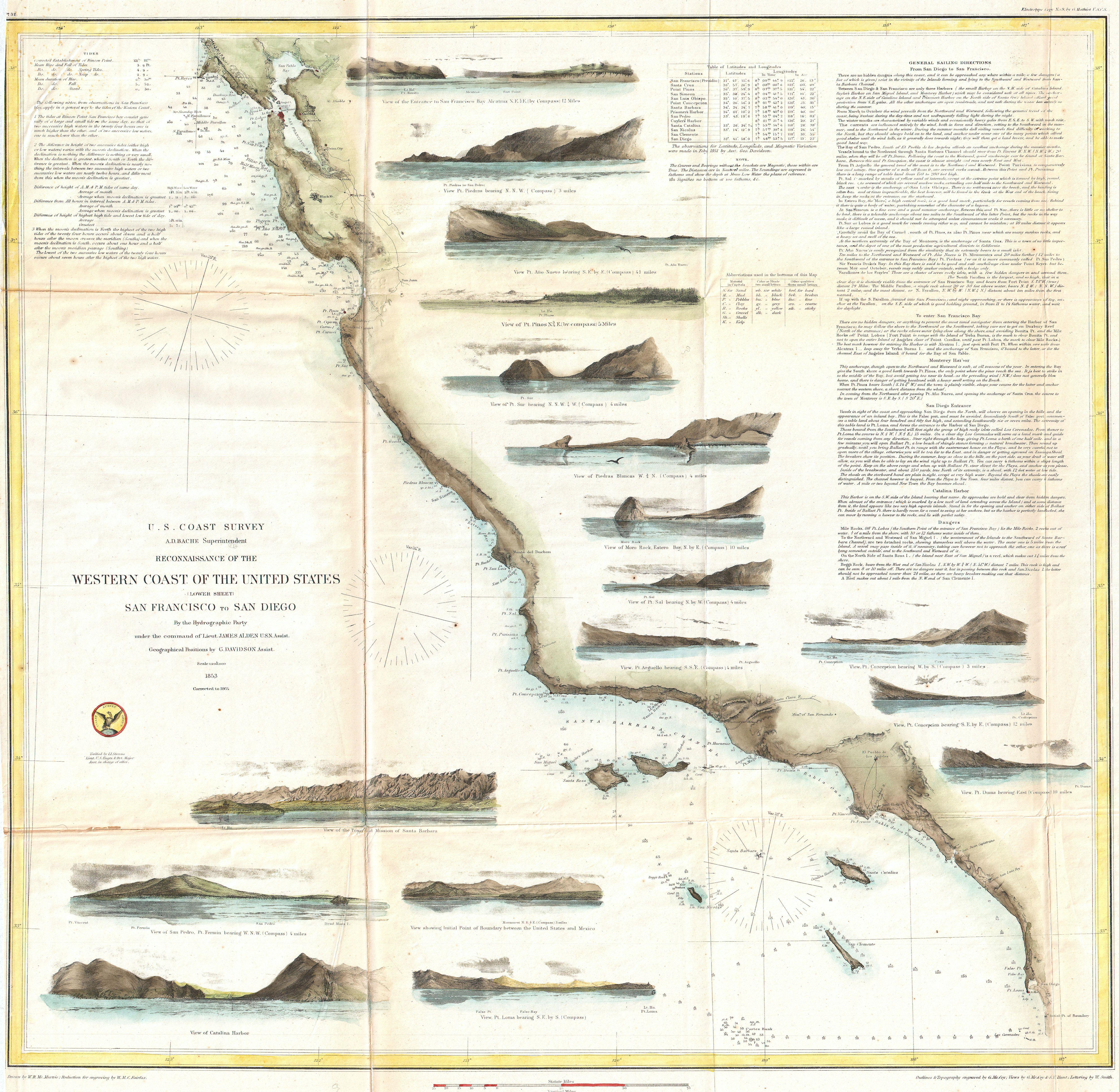
| Reconnaissance of the Western Coast of the United States (Lower Sheet) San Francisco to San Diego. | |||||||
|---|---|---|---|---|---|---|---|
| Artist | |||||||
| Title |
Reconnaissance of the Western Coast of the United States (Lower Sheet) San Francisco to San Diego. |
||||||
| Description |
English: One of the most attractive and desirable of the original U.S. Coast Survey charts of the California Coast. Covers from San Diego and the Mexican border north as far north as Pt. Reyes and the San Francisco Bay.
|
||||||
| Date | 1853 (dated) "Corrected to 1864." | ||||||
| Dimensions | height: 22 in (55.8 cm); width: 23 in (58.4 cm) | ||||||
| Accession number |
Geographicus link: WestCoast2-uscs-1853 |
||||||
| Source/Photographer |
Report of the Superintendant of the U.S. Coast Survey, (1864 edition).
|
||||||
| Permission (Reusing this file) |
|
||||||

File history
Click on a date/time to view the file as it appeared at that time.
| Date/Time | Thumbnail | Dimensions | User | Comment | |
|---|---|---|---|---|---|
| current | 21:33, 22 March 2011 | | 5,000 × 4,881 (4.81 MB) | BotMultichillT (talk | contribs) | {{subst:User:Multichill/Geographicus |link=http://www.geographicus.com/P/AntiqueMap/WestCoast2-uscs-1853 |product_name=1853 U.S. Coast Survey Map of the West Coast of the United States |map_title=Reconnaissance of the Western Coast of the United States (L |
You cannot overwrite this file.
File usage on Commons
The following page uses this file:
File usage on other wikis
The following other wikis use this file: