File:1853 U.S.C.S. Map of Timbalier Bay, Louisiana - Geographicus - TimballierBay-uscs-1853.jpg

Original file (4,000 × 2,721 pixels, file size: 1,001 KB, MIME type: image/jpeg)
Captions
Captions
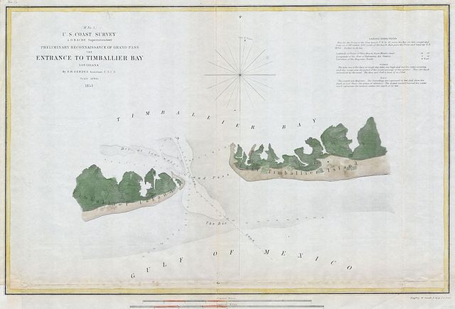
| (H No. 5) Preliminary Reconnaissance of the Grand Pass the Entrance to Timballier Bay, Louisiana. | ||||||
|---|---|---|---|---|---|---|
| Artist | ||||||
| Title |
(H No. 5) Preliminary Reconnaissance of the Grand Pass the Entrance to Timballier Bay, Louisiana. |
|||||
| Description |
English: A rare hand colored 1853 costal chart of the Entrance to Timbalier Bay, Louisiana. Features East and West Timballier Island, depth soundings, and sailing notes. Published under the supervision of A. D. Bache for the 1853 Report of the Superintendant of the U.S. Coast Survey. |
|||||
| Date | 1853 | |||||
| Dimensions | height: 11 in (27.9 cm); width: 17 in (43.1 cm) | |||||
| Accession number |
Geographicus link: TimballierBay-uscs-1853 |
|||||
| Source/Photographer |
|
|||||
| Permission (Reusing this file) |
|
|||||
File history
Click on a date/time to view the file as it appeared at that time.
| Date/Time | Thumbnail | Dimensions | User | Comment | |
|---|---|---|---|---|---|
| current | 20:44, 15 March 2011 | | 4,000 × 2,721 (1,001 KB) | BotMultichill (talk | contribs) | {{subst:User:Multichill/Geographicus |link=http://www.geographicus.com/P/AntiqueMap/TimballierBay-uscs-1853 |product_name=1853 U.S.C.S. Map of Timbalier Bay, Louisiana |map_title=(H No. 5) Preliminary Reconnaissance of the Grand Pass the Entrance to Timb |
You cannot overwrite this file.
File usage on Commons
The following page uses this file: