File:1850 Mitchell Comparitive Chart of the World's Mountains and Rivers - Geographicus - MtsRvrs2-mitchell-1850.jpg
Jump to navigation
Jump to search
Size of this preview: 734 × 599 pixels. Other resolutions: 294 × 240 pixels | 588 × 480 pixels | 941 × 768 pixels | 1,254 × 1,024 pixels | 2,508 × 2,048 pixels | 4,000 × 3,266 pixels.
Original file (4,000 × 3,266 pixels, file size: 4.43 MB, MIME type: image/jpeg)
Captions
Captions
Add a one-line explanation of what this file represents
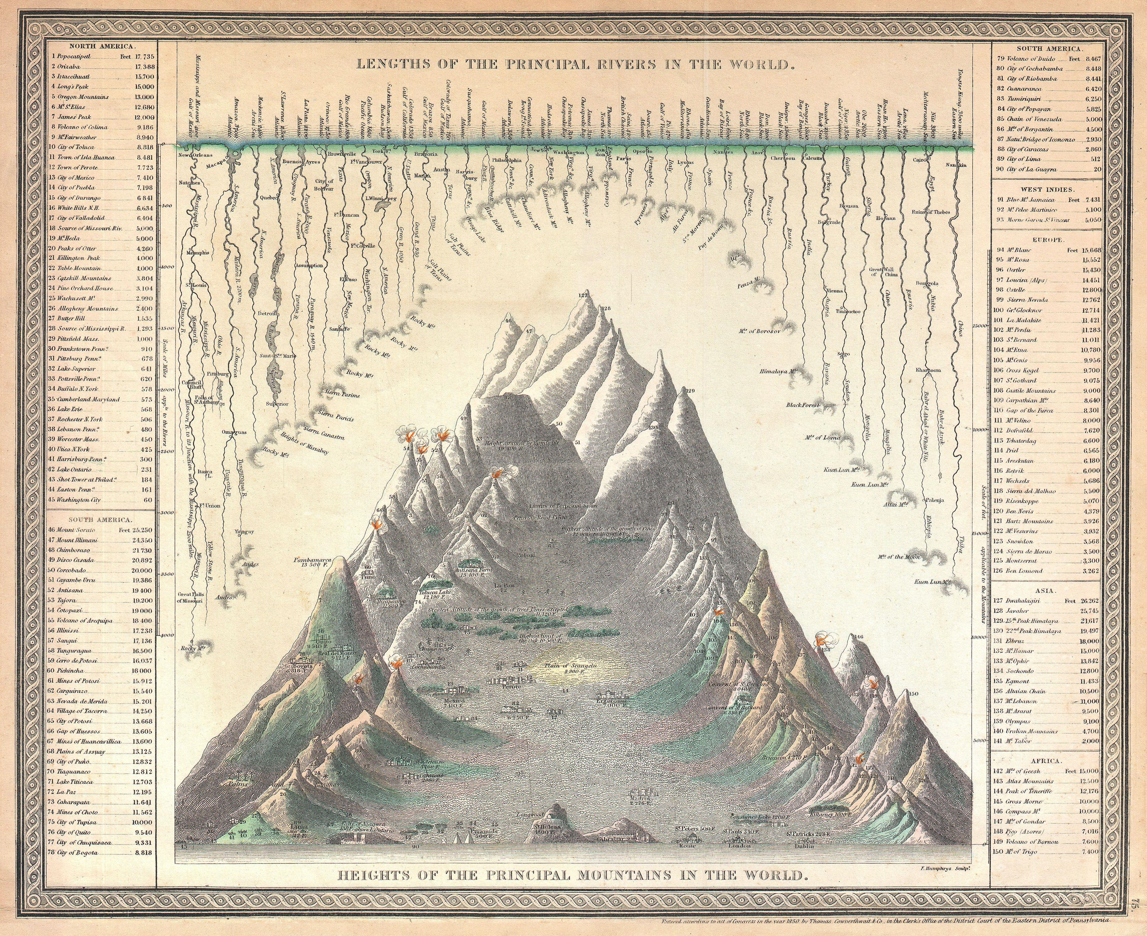
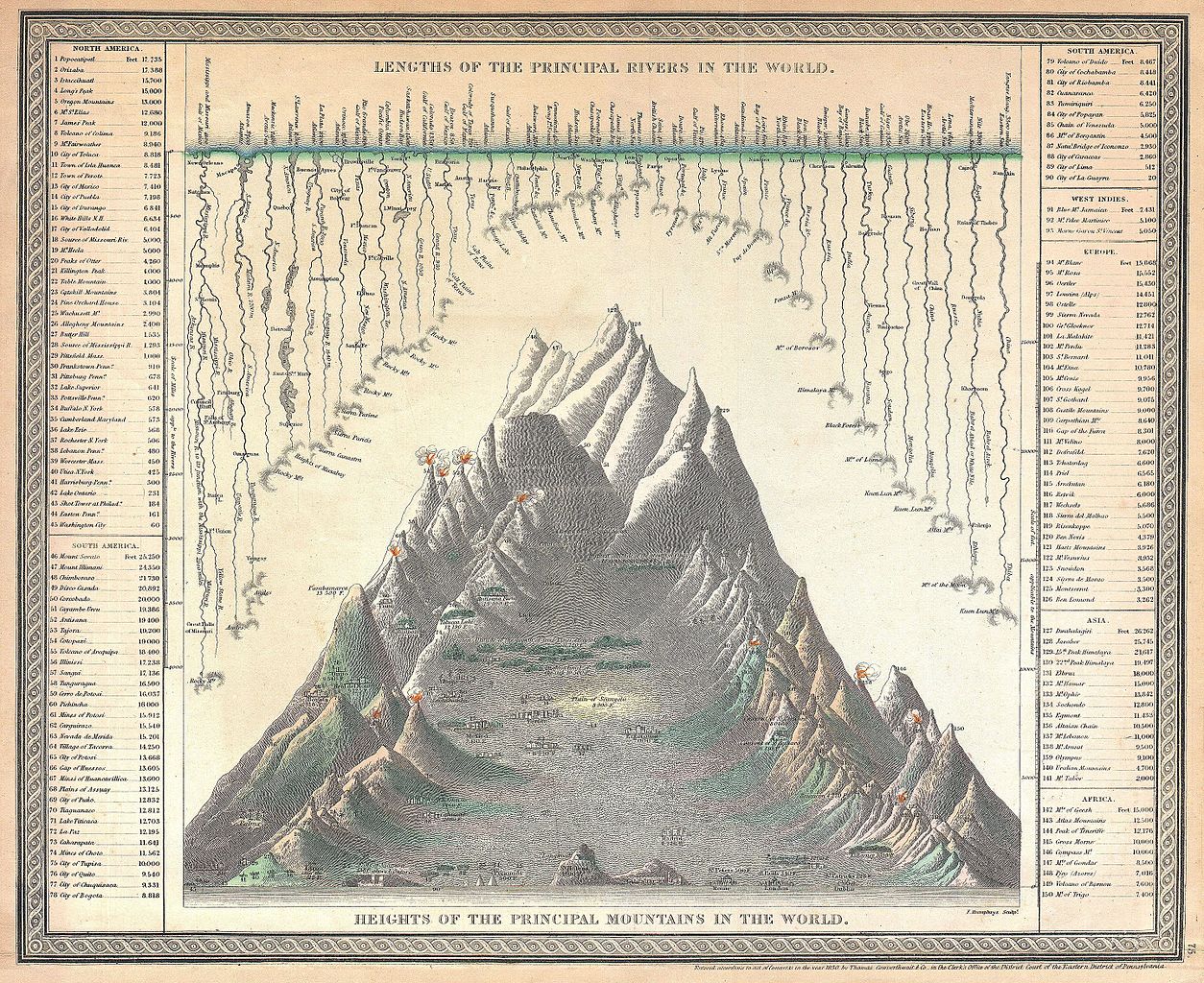
| Samuel Augustus Mitchell: Lengths of the Principal Rivers in the World. - Heights of the Principal Mountains in the World.
( |
||||||||||||||||||||
|---|---|---|---|---|---|---|---|---|---|---|---|---|---|---|---|---|---|---|---|---|
| Artist |
|
|||||||||||||||||||
| Title |
Lengths of the Principal Rivers in the World. - Heights of the Principal Mountains in the World. |
|||||||||||||||||||
| Description |
English: A good example of the S. A. Mitchell Sr. / Cowperthwait map of the principal mountains and rivers of the world. Mountains are shown along the bottom of the map with important cities and geological formations noted at their appropriate elevations. Rivers are arrayed along the top of the map descending from the seas to their sources – where known. The Missouri and Mississippi River systems, at 4100 miles, are listed as the world’s greatest rivers and Dhaulagiri, at 26, 262 ft., the world’s tallest mountain. The mythical Mountains of the Moon are noted as the source of the Nile. Engraved by F. Humphrys for issue as page 75 in the 1850 edition of Mitchell’s New Universal Atlas . |
|||||||||||||||||||
| Date | 1850 (dated) | |||||||||||||||||||
| Dimensions | height: 13 in (33 cm); width: 16 in (40.6 cm) | |||||||||||||||||||
| Accession number |
Geographicus link: MtsRvrs2-mitchell-1850 |
|||||||||||||||||||
| Source/Photographer |
A New Universal Atlas Containing Maps of the various Empires, Kingdoms, States and Republics Of The World. (1850 - 1853 issue)
|
|||||||||||||||||||
| Permission (Reusing this file) |
|
|||||||||||||||||||
File history
Click on a date/time to view the file as it appeared at that time.
| Date/Time | Thumbnail | Dimensions | User | Comment | |
|---|---|---|---|---|---|
| current | 18:52, 17 March 2011 | | 4,000 × 3,266 (4.43 MB) | BotMultichill (talk | contribs) | {{subst:User:Multichill/Geographicus |link=http://www.geographicus.com/P/AntiqueMap/MtsRvrs2-mitchell-1850 |product_name=1850 Mitchell Comparitive Chart of the World's Mountains and Rivers |map_title=Lengths of the Principal Rivers in the World. - Heights |
You cannot overwrite this file.
File usage on Commons
The following page uses this file: