File:1771 Bonne Map of Arabia - Geographicus - Arabia-bonne-1771.jpg
Original file (4,000 × 2,697 pixels, file size: 2.55 MB, MIME type: image/jpeg)
Captions
Captions
|
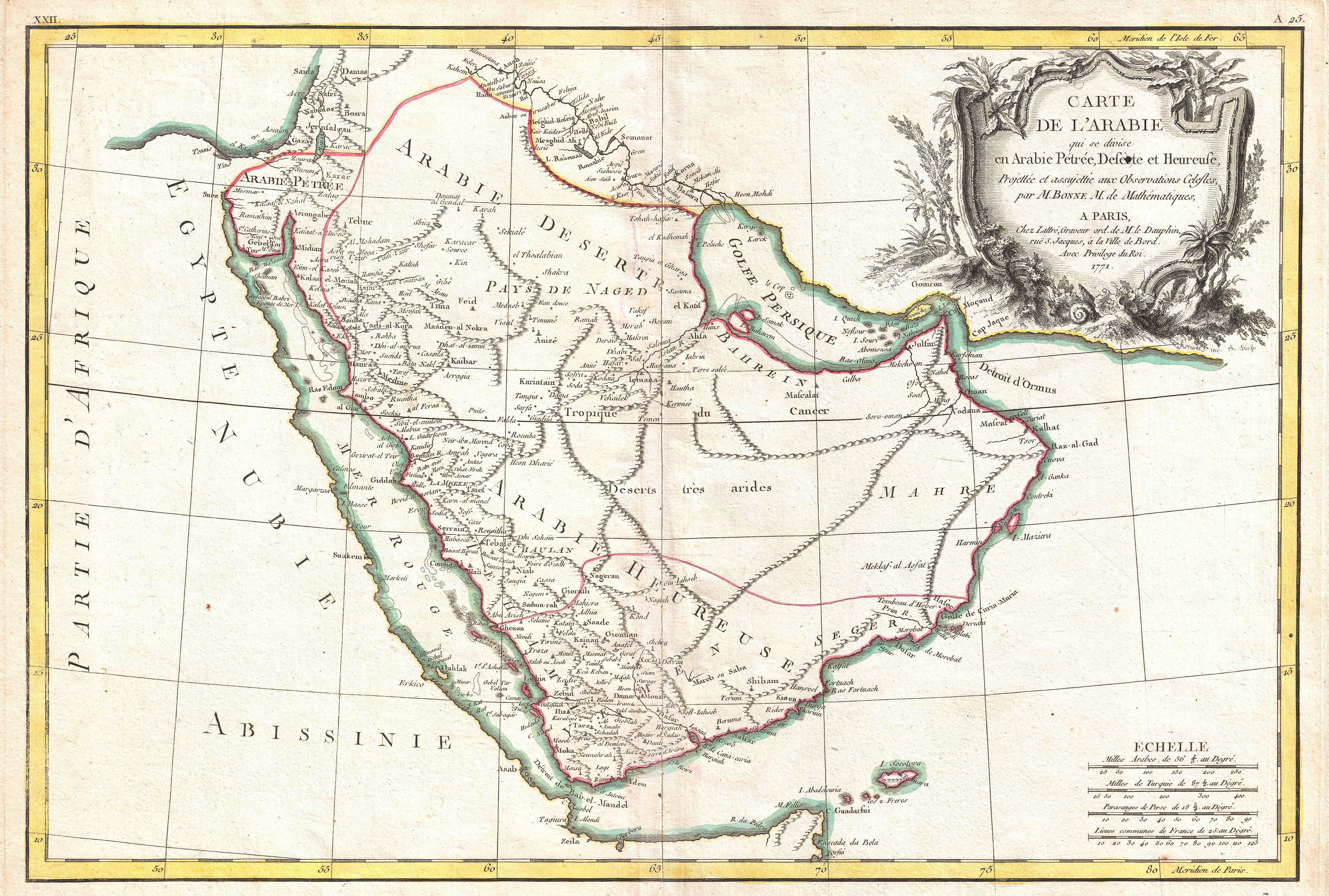
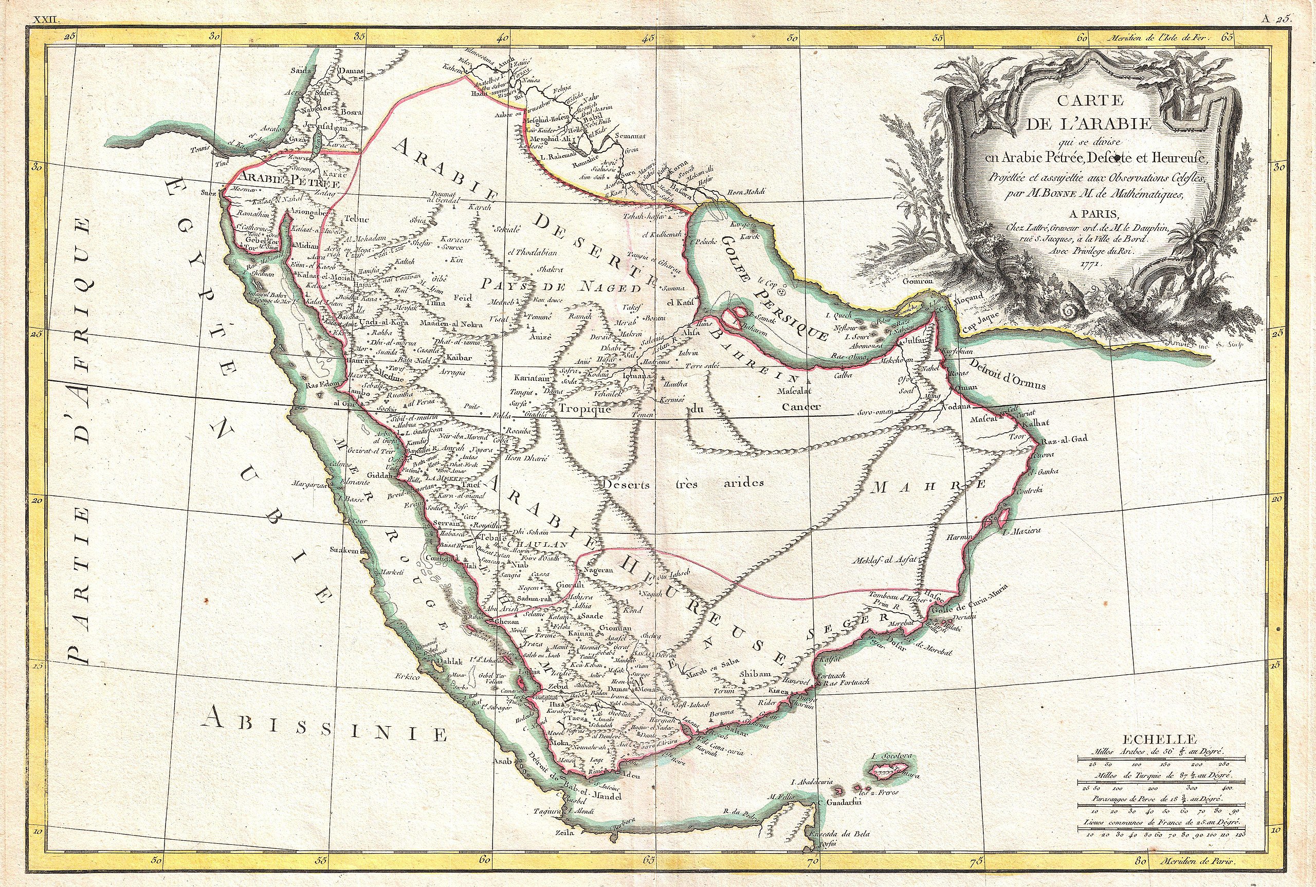
| Rigobert Bonne: Carte deL'Arabie qui se divise en Arabie Petree, Deserte et Heureuse, Projettee en assujettie aux Observations Celestes.
( |
|||||||||||||||||||||||
|---|---|---|---|---|---|---|---|---|---|---|---|---|---|---|---|---|---|---|---|---|---|---|---|
| Artist |
|
||||||||||||||||||||||
| Title |
Carte deL'Arabie qui se divise en Arabie Petree, Deserte et Heureuse, Projettee en assujettie aux Observations Celestes. |
||||||||||||||||||||||
| Description |
العربية: مِثالٌ جميل عن خارطة ريگوبرت بون المُزينة والعائدة إلى سنة 1771م والتي يُصوِّرُ فيها شبه الجزيرة العربيَّة. تُغطي هذه الخارطة المنطقة المُمتدَّة من ساحل البحر المُتوسِّط وُصولًا إلى المُحيط الهندي، ومن البحر الأحمر حتَّى الخليج العربي، شاملةً بذلك عدَّة دُول مُعاصرة هي: السُعوديَّة، وفلسطين، والأُردُن، والكُويت، والعراق، واليمن، وعُمان، والإمارات العربيَّة المُتحدة، والبحرين. كما تظهر فيها أسماء عدَّة مواقع، مثل: طور سيناء، ومكَّة المُكرَّمة، وبيت المقدس، بالإضافة إلى الكثير من المُدن والواحات الحضريَّة الأُخرى. لاحظ كذلك ما تمَّ الإشارة إليه من الشواطئ الضحلة والحُيود المرجانيَّة في كُلٍ من البحر الأحمر والخليج العربي. يظهرُ في الطرف الأيمن العُلوي من الخارطة خرطوشة عنوان مُزخرفة باليد. تُعتبرُ هذه الخريطة إحدى أروع خرائط المنطقة المُشار إليها المرسومة باليد في زمانها. راسمها هو الفرنسي ريگوبرت بون، وقد أتمها سنة 1771م وقد استُعملت في مُؤلّف جان لاتر لِسنة 1776م المُسمَّى «الأطلس المُعاصر».
English: A beautiful example of Rigobert Bonne's 1771 decorative map of the Arabian Peninsula. Covers from the Mediterranean to the Indian Ocean and from the Red Sea to the Persian Gulf. Includes the modern day nations of Saudi Arabia, Palestine, Jordan, Kuwait, Iraq, Yemen, Oman, the United Arab Emirates, and Bahrain. Names Mt. Sinai, Mecca and Jerusalem as well as countless other cities and desert oases. Also notes numerous offshore shoals, reefs, and other dangers in the Red Sea and the Persian Gulf. There is a large decorative title cartouche in the upper right hand quadrant. A fine map of the region. Drawn by R. Bonne in 1771 for issue as plate no. A 25 in Jean Lattre's 1776 issue of the Atlas Moderne . |
||||||||||||||||||||||
| Date | 1771 (dated) | ||||||||||||||||||||||
| Dimensions | height: 12.5 in (31.7 cm); width: 18.2 in (46.3 cm) | ||||||||||||||||||||||
| Accession number |
Geographicus link: Arabia-bonne-1771 |
||||||||||||||||||||||
| Source/Photographer |
Lattre, Jean, Atlas Moderne ou Collection de Cartes sur Toutes les Parties du Globe Terrestre, c. 1775.
|
||||||||||||||||||||||
| Permission (Reusing this file) |
|
||||||||||||||||||||||
File history
Click on a date/time to view the file as it appeared at that time.
| Date/Time | Thumbnail | Dimensions | User | Comment | |
|---|---|---|---|---|---|
| current | 03:01, 23 March 2011 | | 4,000 × 2,697 (2.55 MB) | BotMultichillT (talk | contribs) | {{subst:User:Multichill/Geographicus |link=http://www.geographicus.com/P/AntiqueMap/Arabia-bonne-1771 |product_name=1771 Bonne Map of Arabia |map_title=Carte deL'Arabie qui se divise en Arabie Petree, Deserte et Heureuse, Projettee en assujettie aux Obser |
You cannot overwrite this file.
File usage on Commons
The following page uses this file:
File usage on other wikis
The following other wikis use this file:
- Usage on ar.wikipedia.org
- تاريخ السعودية
- بوابة:الوطن العربي/صورة مختارة/أرشيف
- بوابة:الدولة العثمانية/صورة
- بوابة:مجلس التعاون الخليجي/صورة مختارة/أرشيف
- بوابة:مجلس التعاون الخليجي/صورة مختارة/13
- ويكيبيديا:صور مختارة/رسومات وجداول وخرائط/خرائط
- ويكيبيديا:جائزة المنتج - النصف الثاني لعام 2015/لا روسا وباسم
- ويكيبيديا:ترشيحات الصور المختارة/خارطة فرنسية لشبه الجزيرة العربية
- ويكيبيديا:صورة اليوم المختارة/يناير 2016
- قالب:صورة اليوم المختارة/2016-01-24
- بوابة:الوطن العربي/صورة مختارة/55
- بوابة:الدولة العثمانية/صورة مختارة/17
- ويكيبيديا:صورة اليوم المختارة/مارس 2019
- قالب:صورة اليوم المختارة/2019-03-02
- ويكيبيديا:صورة اليوم المختارة/يناير 2020
- قالب:صورة اليوم المختارة/2020-01-12
- ويكيبيديا:صورة اليوم المختارة/نوفمبر 2022
- قالب:صورة اليوم المختارة/2022-11-14
- Usage on en.wikipedia.org
- Usage on fa.wikipedia.org
- شبهجزیره عربستان
- تحریف نام خلیج فارس
- ویکیپدیا:نگارههای برگزیده/نقشه
- ویکیپدیا:گزیدن نگاره برگزیده/اوت-۲۰۱۴
- ویکیپدیا:گزیدن نگاره برگزیده/1771 Bonne Map of Arabia - Geographicus - Arabia-bonne-1771.jpg
- ویکیپدیا:نگاره روز/آوریل ۲۰۱۶
- بحث کاربر:Alborzagros/بایگانی ۲۳
- الگو:نر/2016-04-29
- الگو:نر محافظت شده/2016-04-29
- Usage on ru.wikipedia.org