File:1750 Bellin Map of the Senegal - Geographicus - Senegal-bellin-1750.jpg
Jump to navigation
Jump to search

Size of this preview: 427 × 599 pixels. Other resolutions: 171 × 240 pixels | 342 × 480 pixels | 547 × 768 pixels | 730 × 1,024 pixels | 1,985 × 2,784 pixels.
Original file (1,985 × 2,784 pixels, file size: 1.13 MB, MIME type: image/jpeg)
Captions
Captions
Add a one-line explanation of what this file represents
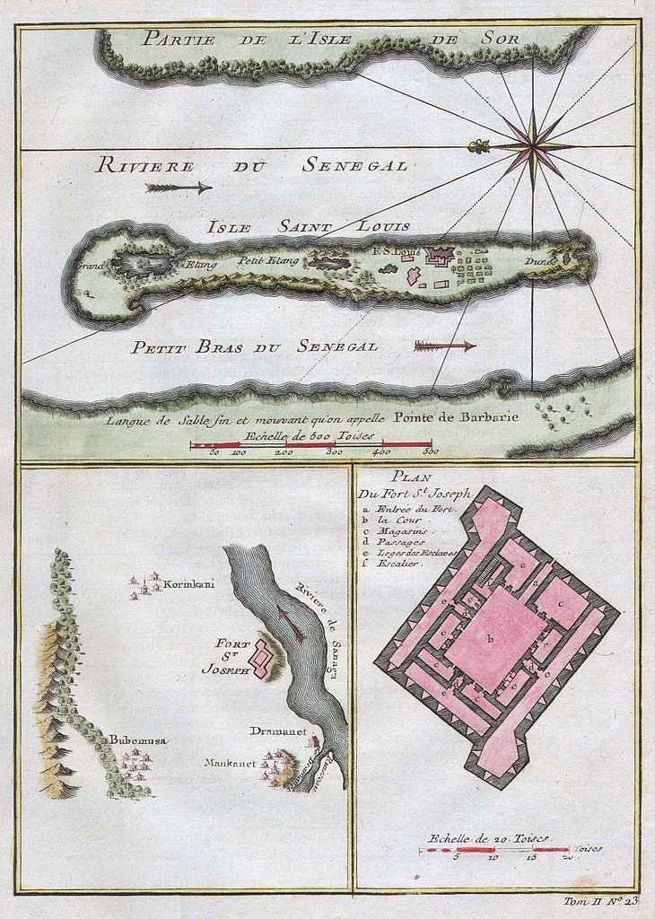
| Jacques-Nicolas Bellin: Riviere du Senegal - Isle Saint Louis - Petit Bras du Senegal - Plan du Fort St. Joseph.
( |
||||||||||||||||||||
|---|---|---|---|---|---|---|---|---|---|---|---|---|---|---|---|---|---|---|---|---|
| Artist |
|
|||||||||||||||||||
| Title |
Riviere du Senegal - Isle Saint Louis - Petit Bras du Senegal - Plan du Fort St. Joseph. |
|||||||||||||||||||
| Description |
English: This stunning 1747 nautical chart by French mapmaker J. C. Bellin, the Elder depicts the Senegal River and the area surrounding Fort St. Joseph & Fort St. Louis. This region was part of the Senegambia & the Company of the Indies Senegal Concession. It was from this port that the French company shipped hundreds of African slaves to its colonies in Louisiana. Today the Senegal River forms the important border between Senegal and Mauritania. This beautiful map depicts individual buildings, trees, and even tiny villages. There is a detailed plan of Fort St. Joseph.. |
|||||||||||||||||||
| Date | 1750 | |||||||||||||||||||
| Dimensions | height: 6.5 in (16.5 cm); width: 9 in (22.8 cm) | |||||||||||||||||||
| Accession number |
Geographicus link: Senegal-bellin-1750 |
|||||||||||||||||||
| Source/Photographer |
|
|||||||||||||||||||
| Permission (Reusing this file) |
|
|||||||||||||||||||
File history
Click on a date/time to view the file as it appeared at that time.
| Date/Time | Thumbnail | Dimensions | User | Comment | |
|---|---|---|---|---|---|
| current | 20:30, 15 March 2011 | | 1,985 × 2,784 (1.13 MB) | BotMultichill (talk | contribs) | {{subst:User:Multichill/Geographicus |link=http://www.geographicus.com/P/AntiqueMap/Senegal-bellin-1750 |product_name=1750 Bellin Map of the Senegal |map_title=Riviere du Senegal - Isle Saint Louis - Petit Bras du Senegal - Plan du Fort St. Joseph. |des |
You cannot overwrite this file.
File usage on Commons
The following page uses this file: