File:نیشابور بیهق قومس.jpg
Jump to navigation
Jump to search

Size of this preview: 800 × 558 pixels. Other resolutions: 320 × 223 pixels | 640 × 446 pixels | 931 × 649 pixels.
Original file (931 × 649 pixels, file size: 191 KB, MIME type: image/jpeg)
Captions
Captions
Add a one-line explanation of what this file represents
Summary[edit]
| Description |
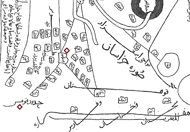
فارسی: بریدهای از نقشه «خراسان» مندرج در کتاب «صورة الارض» تالیف این حوقل (درگذشته در سالهای پس از ۳۶۷ هجری)؛ ترسیم شده در قرن چهارم هجری؛ در این بریده نقاط مهم خراسان غربی آمده است و نقاط شاخص ناحیه بیهق (سبزوار، خسروجرد، بهمنآباد و مزینان) در چپ نگاره نقشه (در میانه راه قومس به نیشابور) دیده میشوند. |
| Date | |
| Source | کتاب «صوره الارض» نوشته ابن حوقل جغرافیدان قرن چهارم هجری، |
| Author | ترسیم کننده تصویر، محمد بن علی بن حوقل نصیبی است که کمی پس از 367 هجری درگذشته است. |
Licensing[edit]
|
This work is in the public domain in its country of origin and other countries and areas where the copyright term is the author's life plus 100 years or fewer. | |
| This file has been identified as being free of known restrictions under copyright law, including all related and neighboring rights. | |
File history
Click on a date/time to view the file as it appeared at that time.
| Date/Time | Thumbnail | Dimensions | User | Comment | |
|---|---|---|---|---|---|
| current | 16:46, 12 August 2018 | | 931 × 649 (191 KB) | Reyvand (talk | contribs) | User created page with UploadWizard |
You cannot overwrite this file.
File usage on Commons
There are no pages that use this file.
File usage on other wikis
The following other wikis use this file:
- Usage on fa.wikipedia.org
- Usage on mzn.wikipedia.org