File:"BOUNDARY BRIEF" in 1973 map by Office of the Geographer, Dept. of State (US), from- Angola-South-West Africa boundary. LOC 84692090 (cropped).jpg
Jump to navigation
Jump to search

Size of this preview: 480 × 599 pixels. Other resolutions: 192 × 240 pixels | 385 × 480 pixels | 616 × 768 pixels | 1,188 × 1,482 pixels.
Original file (1,188 × 1,482 pixels, file size: 249 KB, MIME type: image/jpeg)
Captions
Captions
Add a one-line explanation of what this file represents
Summary[edit]
| Description |
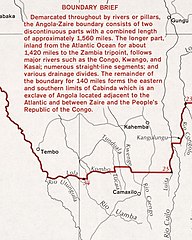
English: "501802 8-73" "Source: Office of the Geographer, Dept. of State." Includes note and key map. Available also through the Library of Congress Web site as a raster image. |
||
| Title | Angola--South-West Africa boundary. | ||
| Shelf ID | G8641.F2 1973 .U5 | ||
| Date | |||
| Source | https://www.loc.gov/item/84692090/ | ||
| Author | United States. Central Intelligence Agency; United States. Department Of State. Office Of The Geographer | ||
| Permission (Reusing this file) |
|
||
| Other versions |
|
||
| Location | Namibia · Angola | ||
| Part of | American Memory · General Maps · Catalog · Geography And Map Division | ||
| Subject | Boundaries · Namibia · Angola · Maps |


,_from-_Angola-South-West_Africa_boundary._LOC_84692090_(cropped).jpg&action=edit§ion=1)
Licensing[edit]
,_from-_Angola-South-West_Africa_boundary._LOC_84692090_(cropped).jpg&action=edit§ion=2)
| This image is a work of a Central Intelligence Agency employee, taken or made as part of that person's official duties. As a Work of the United States Government, this image or media is in the public domain in the United States.
|

|
File history
Click on a date/time to view the file as it appeared at that time.
| Date/Time | Thumbnail | Dimensions | User | Comment | |
|---|---|---|---|---|---|
| current | 03:33, 22 December 2019 | | 1,188 × 1,482 (249 KB) | Tibet Nation (talk | contribs) | File:Angola-South-West Africa boundary. LOC 84692090.jpg cropped 79 % horizontally, 64 % vertically using CropTool with lossless mode. |
You cannot overwrite this file.
File usage on Commons
The following page uses this file:
,_from-_Angola-South-West_Africa_boundary._LOC_84692090_(cropped).jpg&oldid=740954746)