Commons:Featured picture candidates/File:Iceland satellite.jpg
Jump to navigation
Jump to search

File:Iceland satellite.jpg[edit]
Voting period is over. Please don't add any new votes.Voting period ends on 30 Jun 2011 at 19:03:16 (UTC)
Visit the nomination page to add or modify image notes.

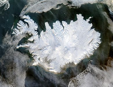
 Info created by NASA - uploaded by User:Ævar Arnfjörð Bjarmason - nominated by User:Flukas -- Flukas (talk) 19:03, 21 June 2011 (UTC)
 Support good technical quality, unusual view of fully snow covered island-- Flukas (talk) 19:03, 21 June 2011 (UTC)