Commons:Featured picture candidates/File:General Map of Switzerland.jpg
Jump to navigation
Jump to search

File:General Map of Switzerland.jpg, featured[edit]
Voting period is over. Please don't add any new votes.Voting period ends on 6 Oct 2023 at 12:26:02 (UTC)
Visit the nomination page to add or modify image notes.

- Gallery: Commons:Featured pictures/Non-photographic media/Maps#Maps of Europe
 Info created by Swiss Federal Office of Topography, uploaded by Zacharie Grossen, nominated by Yann
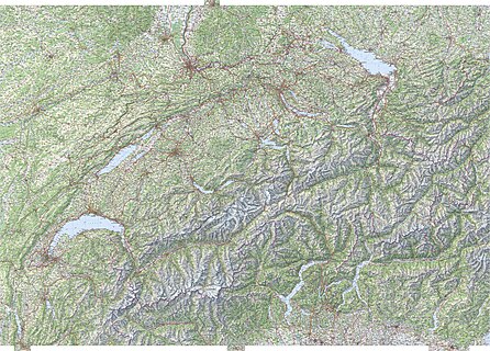
 Support The most detailed map of Switzerland, and probably better than most modern maps on Commons. It is great that the Swiss Federal Office of Topography releases its works under a free license, and featuring this may encourage other offices to do so. We also have coverage of the whole of Switzerland at the 1:25,000 scale. -- Yann (talk) 12:26, 27 September 2023 (UTC)
- Support - ABAL1412🇻🇳🇸🇺🇷🇺 (talk ☭) 15:01, 27 September 2023 (UTC)
- Support --Harlock81 (talk) 18:06, 27 September 2023 (UTC)
- Support --Kritzolina (talk) 19:02, 27 September 2023 (UTC)
- Support Top quality. -- Ikan Kekek (talk) 21:32, 27 September 2023 (UTC)
- Support Very detailed map. ★ 00:38, 28 September 2023 (UTC)
 Strong oppose While this is obviously derived from a high quality professional map, this version on Commons completely lacks the legend. That's a no-go for pretty much any kind of map. The legend can be part of the image file or part of the description, but it must be there – even if we can guess what most of the things mean. It also lacks any spatial reference beyond the undefined grid overlay – I'm guessing that's probably some sort of UTM? Happy to support once that has been fixed.
- There is a legend on older versions of the maps, e.g. File:Swisstopo Skiroutenkarte Arolla LT LK 283 S 1950.tif, and it is most probably the same. I have asked someone who might know. Yann (talk) 09:25, 28 September 2023 (UTC)
- I just discovered that source maps for this file were not uploaded. I am doing that now. Yann (talk) 12:47, 28 September 2023 (UTC)
- I added some of the missing metadata. Enhancing999 (talk) 15:33, 28 September 2023 (UTC)
- @El Grafo: I uploaded and added the legend of Swisstopo maps, 1:50,000, 1950. This is the best we have now. Yann (talk) 19:26, 28 September 2023 (UTC)
- That doesn't match this map at all. For example, that legend has very detailed symbolism for railway infrastructure while the map just has simple lines for tracks and rectangles for stations – in a different color. The legend uses serif fonts for pretty much anything while the map uses sans-serif for anything but mountains and water features. I could go on. The only thing worse than having no legend at all is having one that does not match the map. Please just remove it. El Grafo (talk) 07:30, 29 September 2023 (UTC)
 Oppose Aside from a legend as mentioned by El Grafo (which is a must for a map of this scale), this is a bad map in general – labels way too small to be legible unless zoomed really far in (which is a big red flag for FP), too large that it crashes my browser every 5 seconds (and no, my current Wi-Fi speeds are 183 Mbps download and 80 Mbps upload), and that small random patch at the top – this is not a map that I would even give the green light for QI. --SHB2000 (talk) 10:46, 28 September 2023 (UTC)
- @SHB2000: The small size of the labels is a feature, not a bug. If they were larger, they would overlay other information. This is meant to be used zoomed in, and as a source for crops. For looking into the details without loading the whole map, you can use the source files. Yann (talk) 16:04, 28 September 2023 (UTC)
- I know – and I see that as a net negative for this map. --SHB2000 (talk) 09:43, 29 September 2023 (UTC)
- @SHB2000: The small size of the labels is a feature, not a bug. If they were larger, they would overlay other information. This is meant to be used zoomed in, and as a source for crops. For looking into the details without loading the whole map, you can use the source files. Yann (talk) 16:04, 28 September 2023 (UTC)
- Oppose because of broken ZommViewer, and inability to see the whole map with a browser are really bad faith (not surprising from CJS). This version is obviously not meant to be used that way. I submitted a bug report when I found the issue with ZommViewer, and I can't do anything about it. Yann (talk) 12:45, 28 September 2023 (UTC)
- It's not bad faith and a typical snide comment not surprising from Yann. Users are supposed to examine a file to support or oppose it and if I cannot do that them I am entitles to oppose. Charlesjsharp (talk) 16:19, 28 September 2023 (UTC)
- Yeah, we can't really unfeature all images because of ZoomViewer. Maybe the template should be blank until it's back. Enhancing999 (talk) 15:34, 28 September 2023 (UTC)
- Disapprove Hey Yann, look, I already disapproved your last nomination, and I'll do the same with this one. Imagine the reaction Commons will receive if a poor map is displayed on the home page. Not good, I see. Therefore, we require high-caliber, charismatic photographs. This image, in my opinion, does not fit either of these. 20 upper 19:22, 28 September 2023 (UTC)
- @20 upper: Please be specific. What is the issue with this file? I answered to objections above. Yann (talk) 19:30, 28 September 2023 (UTC)
- Since you asked for specifics, here they are: 1. The white background is obviously visible, which I believe diminishes the value of the map. 2. No legend is present.
3. Too big an image! ZoomViewer won't let me view, therefore I'll assume the details aren't of the highest caliber.20 upper 19:48, 28 September 2023 (UTC)
- Since you asked for specifics, here they are: 1. The white background is obviously visible, which I believe diminishes the value of the map. 2. No legend is present.
- Your assumption is wrong. -- Ikan Kekek (talk) 07:00, 29 September 2023 (UTC)
- I got to examine the entire map, and boy was I wrong. 20 upper 13:54, 29 September 2023 (UTC)
- Before opening entirely the file, I thought: what a map is this without any discernible feature apart from lakes and mountains!? However, if you open it, it is full of details. Also the spots that extend beyond the boarders of the main rectangular shape are perfectly reasonable, because they regard four important cities in Italy, France, and Germany which would be cut otherwise. The opposition to the nomination is licit, but why assume that the image is insufficient for sure, if you cannot open it? --Harlock81 (talk) 09:08, 29 September 2023 (UTC)
- @20 upper: Please be specific. What is the issue with this file? I answered to objections above. Yann (talk) 19:30, 28 September 2023 (UTC)
- Info @SHB2000, Charlesjsharp, and 20 upper: and everyone else missing Zoomviewer: Enhancing999 kindly georeferenced the whole thing, so you can also view it here in the Wikimaps Warper (albeit warped a bit to match OSM's Web Mercator projection). --El Grafo (talk) 11:10, 29 September 2023 (UTC)
- Nice – however, the lack of legend is still a big no-no for me. --SHB2000 (talk) 11:40, 29 September 2023 (UTC)
- Map shows up as low quality on my PC. Charlesjsharp (talk) 18:58, 29 September 2023 (UTC)
- LoL. Buy a new PC... and a manual about "How to make credible oppose votes". Yann (talk) 16:29, 30 September 2023 (UTC)
- You need to switch from Preview mode to Show mode, then you will see the map in its full resolution. Zach (Talk) 16:56, 30 September 2023 (UTC)
- Thank you. Such a shame Yann is incapable of any politeness. Shoundn't be an Admin. Oppose I can now read the map, but I find no legend, no scale, no date etc. Charlesjsharp (talk) 17:26, 30 September 2023 (UTC)
- Thank you. Such a shame Yann is incapable of any politeness. Shoundn't be an Admin.
- Info First of all thank you @Yann: for the nomination (I have the paper version of the map and I absolutely love it, hence the upload). For the legend of the map, there is a short pdf document published by Swisstopo: Conventional signs for Swiss National Maps (linked here). I think we could simply use that pdf or maybe just part of it (I'm pretty sure it is as free to use as the maps are). Zach (Talk) 11:41, 30 September 2023 (UTC)
- Legend added. Zach (Talk) 10:21, 1 October 2023 (UTC)
- projection added too. Zach (Talk) 10:00, 2 October 2023 (UTC)
- Support now that the legend is sorted out. Enhancing999 (talk) 10:56, 1 October 2023 (UTC)
- Support --MZaplotnik(talk) 14:33, 1 October 2023 (UTC)
 Comment Thanks for adding CRS information and a link to the legend – I've removed my oppose above. --El Grafo (talk) 13:51, 2 October 2023 (UTC)
- The reasons I'm hesitating to support are 1) I'd prefer the legend to be part of the map rather than a link and 2) I'm still missing coordinate labels for the grid lines. El Grafo (talk) 07:10, 3 October 2023 (UTC)
- I understand your hesitation. I edited the description to display the legend. It includes some explanation on lines of the Swiss grid. I think (1) is true for paper maps even though smaller scale Swiss maps traditionally had been sold without legends (or the legend distributed separately). For digital files on Commons, it's a bit like including borders on images: it can be ok, but I'd prefer we have a version without any. Enhancing999 (talk) 08:48, 3 October 2023 (UTC)
- The reasons I'm hesitating to support are 1) I'd prefer the legend to be part of the map rather than a link and 2) I'm still missing coordinate labels for the grid lines. El Grafo (talk) 07:10, 3 October 2023 (UTC)
- Support--Princess 🍵 Rosalina 21071 03:35, 6 October 2023 (UTC)
- Support --Palauenc05 (talk) 10:19, 6 October 2023 (UTC)
Confirmed results:
Result: 10 support, 3 oppose, 0 neutral → featured. /-- Radomianin (talk) 13:52, 6 October 2023 (UTC)
This image will be added to the FP gallery: Non-photographic media/Maps#Maps of Europe