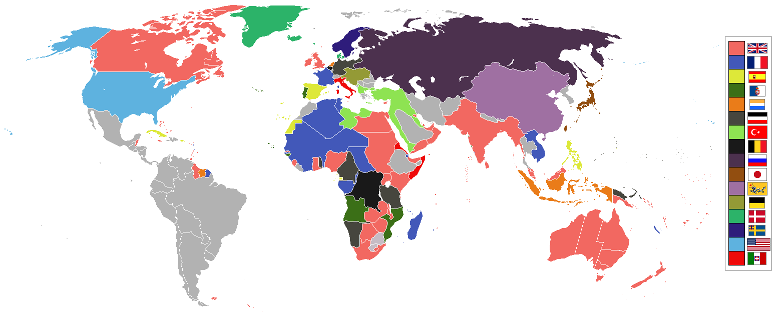
File:World 1898 empires colonies territory.png
Original file (1,560 × 624 pixels, file size: 45 KB, MIME type: image/png)
Captions
Captions
| Description |
|
||||||||||||||||
| Date | 9 June 2006 (original upload date) | ||||||||||||||||
| Source | No machine-readable source provided. Own work assumed (based on copyright claims). | ||||||||||||||||
| Author | No machine-readable author provided. Roke~commonswiki assumed (based on copyright claims). | ||||||||||||||||
.jpg)
._LOC_2001620596.jpg)

|
This historical map image could be re-created using vector graphics as an SVG file. This has several advantages; see Commons:Media for cleanup for more information. If an SVG form of this image is available, please upload it and afterwards replace this template with
{{vector version available|new image name}}.
It is recommended to name the SVG file “World 1898 empires colonies territory.svg”—then the template Vector version available (or Vva) does not need the new image name parameter. |
Summary
[edit]
Español
[edit]
Imperios del mundo y sus colonias, (antes de la Guerra Española-Estadounidense, la Guerra de los Boxer y la Guerra de los Boer, derivado de Image:BlankMap-World-WWI.PNG
English
[edit]
World empires and colonies 1898, (just before the Spanish–American War, Boxer Rebellion and Boer War), derived from Image:BlankMap-World-WWI.PNG
Tiếng Việt
[edit]
Français
[edit]
Empires et colonies du monde 1898, (juste avant la guerre hispano-américaine, la révolte des Boxers et la guerre des Boers, dérivée de Image:BlankMap-World-WWI.PNG).
عربي
[edit]
مستوحاة من Image:BlankMap-World-WWI.PNG
中文 (繁體)
[edit]
中文 (简体)
[edit]
Deutsch
[edit]
Italiano
[edit]
Bahasa Indonesia
[edit]
Imperium dan koloni di dunia pada tahun 1898 (sebelum Perang Spanyol-Amerika, Pemberontakan Boxer dan Perang Boer).
Македонски
[edit]
Империи и колонии во 1898 г., (веднаш пред Шпанско-американската војна, Боксерското востание и Бурската војна), создадено врз основа на Image:BlankMap-World-WWI.PNG
Nederlands
[edit]
Wereldrijken en kolonies 1898, (net voor de Spaans-Amerikaanse oorlog, Boxer opstand en Boerenoorlog).
Polski
[edit]
Imperia i kolonie świata w 1898, (przed wojną amerykańsko-hiszpańską, powstaniem bokserów i wojnami burskimi), na podstawie Image:BlankMap-World-WWI.PNG
Português
[edit]
Русский
[edit]
Українська
[edit]
한국어
[edit]
1898년 세계의 각 제국과 국가들을 나타낸 지도이다. (미국-스페인 전쟁, 의화단 운동, 보어 전쟁 전의 상황이다.)
日本語
[edit]
עברית
[edit]
gurupletos
See also
[edit]
| Maps of world history | |
| BC | |
|
| |
| AD |
1 · 50 · 100 · 200 · 250 · 300 · 400 · 500 · 700 · 750 · 820 · 900 · 1200 · 1500 · 1556 · 1648 · 1700 · 1750 · 1815 · 1859 · 1871 · 1914 · 1935 · 1954 · 1989 · 2000 · |
|
Maps of colonization history | |
|
see also: Eastern Hemisphere only maps template (1300BC-1500AD) | |
| (this template: · view · discuss ) | |
Licensing
[edit]

|
Permission is granted to copy, distribute and/or modify this document under the terms of the GNU Free Documentation License, Version 1.2 or any later version published by the Free Software Foundation; with no Invariant Sections, no Front-Cover Texts, and no Back-Cover Texts. A copy of the license is included in the section entitled GNU Free Documentation License. |
| This file is licensed under the Creative Commons Attribution-Share Alike 3.0 Unported license. | ||
| ||
| This licensing tag was added to this file as part of the GFDL licensing update. |
| Annotations | This image is annotated: View the annotations at Commons |
File history
Click on a date/time to view the file as it appeared at that time.
| Date/Time | Thumbnail | Dimensions | User | Comment | |
|---|---|---|---|---|---|
| current | 09:16, 8 November 2021 | 1,560 × 624 (45 KB) | Randomastwritter (talk | contribs) | jubaland | |
| 07:24, 3 July 2019 | 1,560 × 624 (40 KB) | Insider (talk | contribs) | the border between East Africa Protectorate and Italian Somaliland per User talk:Insider#File:World 1898 empires colonies territory.png | ||
| 07:18, 31 January 2019 | 1,560 × 624 (40 KB) | Insider (talk | contribs) | Arkticheskiy Institut Islands, Izvestiy TSIK Islands, Kirov Islands, Sverdrup Island, Russky Island, Uyedineniya Island, Vize Island and Ushakov Island also is terra nullis at 1898 | ||
| 10:34, 30 January 2019 | 1,560 × 624 (40 KB) | Insider (talk | contribs) | In 1898, Grumant, Jan Mayen Island, Severnaya Zemlya, Franz Josef Land, Wrangel island was terra nullius. Fixed Aleutian and Solovki islands. | ||
| 15:56, 6 August 2018 | 1,560 × 624 (45 KB) | Lord Obvious (talk | contribs) | |||
| 12:04, 12 April 2016 | 1,560 × 624 (45 KB) | The- (talk | contribs) | Minor fixes | ||
| 21:59, 11 April 2016 | 1,560 × 624 (45 KB) | The- (talk | contribs) | Minor fixes | ||
| 21:52, 11 April 2016 | 1,560 × 624 (44 KB) | The- (talk | contribs) | More accurate map | ||
| 02:59, 3 August 2014 | 1,554 × 628 (41 KB) | Alvin Lee (talk | contribs) | Correcting the boundaries of Russia and China | ||
| 18:36, 23 October 2012 | 1,554 × 628 (62 KB) | Franco310397 (talk | contribs) | Spanish presence in Micronesia (Oceania) included in the Captaincy General of the Philippines. In the Caroline Islands and the Mariana Islands. |
You cannot overwrite this file.
File usage on Commons
The following 3 pages use this file:
File usage on other wikis
The following other wikis use this file:
- Usage on af.wikipedia.org
- Usage on als.wikipedia.org
- Usage on am.wikipedia.org
- Usage on an.wikipedia.org
- Usage on ar.wikipedia.org
- Usage on av.wikipedia.org
- Usage on az.wikipedia.org
- Usage on ba.wikipedia.org
- Usage on bg.wikipedia.org
- Usage on bn.wikipedia.org
- Usage on bs.wikipedia.org
- Usage on ca.wikipedia.org
- Usage on ceb.wikipedia.org
- Usage on ce.wikipedia.org
- Usage on cs.wikipedia.org
- Usage on da.wikipedia.org
- Usage on de.wikipedia.org
- Usage on de.wiktionary.org
- Usage on el.wikipedia.org
- Usage on en.wikipedia.org
View more global usage of this file.